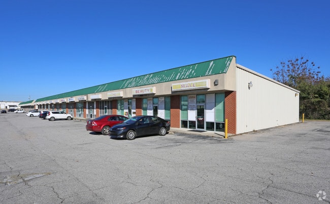
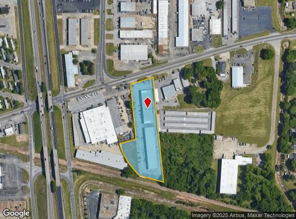
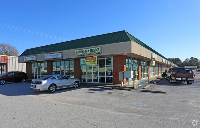
Property Record
5510 Wares Ferry Rd, Montgomery, AL 36117
NEARBY LISTINGS FOR SALE OR LEASE
Property Detail
5510 Wares Ferry Rd
Montgomery, AL
Figh Plat
10-01-01-4-005-001.002
ALSO PORTION OF LOT C-2 JOHN FIGH RESUB 3 PLATBOOK 27 PG 250, DESC AS COMMENCE NE CORNER SAID LOT C-2 THN SE 379.1FT TO POB,
Stripcommercialcenter
Montgomery
X
Alabama
01101C0114J
1
2025
2.79 AC
2025
North Montgomery
005402
Montgomery
14,078 SF
DEMOGRAPHICS near 5510 Wares Ferry Rd
1 Mile
3 Mile
5 Mile
2024 Total Population
6,679
40,641
106,514
2029 Population
6,457
39,208
103,140
Pop Growth 2024-2029
(3.32%)
(3.53%)
(3.17%)
Average Age
37
38
38
2024 Total Households
2,696
17,642
45,733
HH Growth 2024-2029
(3.19%)
(3.56%)
(3.30%)
Median Household Inc
$50,242
$55,043
$53,787
Avg Household Size
2.40
2.20
2.30
2024 Avg HH Vehicles
2.00
2.00
2.00
Median Home Value
$96,557
$148,122
$158,186
Median Year Built
1976
1982
1981
Nearby Places
Map Layers
Map Styles
 Street
 Aerial
- Restaurants
- Banks
- Shops
- Fitness
- Groceries
PUBLIC TRANSPORTATION
AIRPORT
Montgomery Regional (Dannelly Field)
DRIVE
WALK
Distance
Montgomery Regional (Dannelly Field)
22 min
15.5 mi
SALE & LEASE HISTORY
LISTING DATE
SALE/LEASE

Sep 25, 2016
For Lease
Nearby Properties
Address
Land Use
TOTAL SIZE
Lot Size
Zoning
Address
Land Use
TOTAL SIZE
Lot Size
Zoning
117,161 SF
12.07 AC
INST
Address
Land Use
TOTAL SIZE
Lot Size
Zoning
4,836 SF
16.25 AC
R-75-M
Address
Land Use
TOTAL SIZE
Lot Size
Zoning
385,644 SF
26.60 AC
B-2
Address
Land Use
TOTAL SIZE
Lot Size
Zoning
31,205 SF
59 AC
INST
Address
Land Use
TOTAL SIZE
Lot Size
Zoning
2,885 SF
14 AC
R-75-M
Address
Land Use
TOTAL SIZE
Lot Size
Zoning
92,200 SF
9.74 AC
O-1
Address
Land Use
TOTAL SIZE
Lot Size
Zoning
7,040 SF
11.70 AC
R-65-M
Address
Land Use
TOTAL SIZE
Lot Size
Zoning
24,360 SF
26.59 AC
R-65-M
Address
Land Use
TOTAL SIZE
Lot Size
Zoning
224,132 SF
26.57 AC
AGR-2
Address
Land Use
TOTAL SIZE
Lot Size
Zoning
223,000 SF
26 AC
O-1
Address
Land Use
TOTAL SIZE
Lot Size
Zoning
1,964 SF
13.40 AC
R-75-M
Address
Land Use
TOTAL SIZE
Lot Size
Zoning
5,606 SF
21 AC
R-75-M
Address
Land Use
TOTAL SIZE
Lot Size
Zoning
591,904 SF
26 AC
M-1
Address
Land Use
TOTAL SIZE
Lot Size
Zoning
108,176 SF
4.27 AC
B-1-B
Address
Land Use
TOTAL SIZE
Lot Size
Zoning
154,375 SF
21.19 AC
B-3
Address
Land Use
TOTAL SIZE
Lot Size
Zoning
75,510 SF
10.97 AC
B-2
Address
Land Use
TOTAL SIZE
Lot Size
Zoning
2,679 SF
10.77 AC
R-75-M
Address
Land Use
TOTAL SIZE
Lot Size
Zoning
82,638 SF
O-1
Address
Land Use
TOTAL SIZE
Lot Size
Zoning
84,764 SF
5.20 AC
B-2
Address
Land Use
TOTAL SIZE
Lot Size
Zoning
65,394 SF
13 AC
B-2
Address
Land Use
TOTAL SIZE
Lot Size
Zoning
8,697 SF
21.84 AC
R-20-T
Address
Land Use
TOTAL SIZE
Lot Size
Zoning
2,397 SF
4.35 AC
R-75-M
Address
Land Use
TOTAL SIZE
Lot Size
Zoning
3,458 SF
15.34 AC
R-65-M
Address
Land Use
TOTAL SIZE
Lot Size
Zoning
2,200 SF
11.06 AC
R-75-M
Address
Land Use
TOTAL SIZE
Lot Size
Zoning
6,024 SF
17.30 AC
R-75-M
Address
Land Use
TOTAL SIZE
Lot Size
Zoning
25,809 SF
11.80 AC
B-3
Address
Land Use
TOTAL SIZE
Lot Size
Zoning
187,340 SF
22.80 AC
M-1
Address
Land Use
TOTAL SIZE
Lot Size
Zoning
5,624 SF
14.34 AC
R-75-M
Address
Land Use
TOTAL SIZE
Lot Size
Zoning
11,190 SF
13.75 AC
AGR-1
Address
Land Use
TOTAL SIZE
Lot Size
Zoning
30,747 SF
21.58 AC
M-1
The World's #1 Commercial Real Estate Marketplace
Connect with us
© 2025 CoStar Group
The information above has been obtained from sources believed reliable. While we do not doubt its accuracy we have not verified it and make no guarantee, warranty or representation about it. It is your responsibility to independently confirm its accuracy and completeness. Any projections, opinions, assumptions, or estimates used are for example only and do not represent the current or future performance of the property. The value of this transaction to you depends on tax and other factors which should be evaluated by your tax, financial, and legal advisors. You and your advisors should conduct a careful, independent investigation of the property to determine to your satisfaction the suitability of the property for your needs.