Property Record
555 Codoni Ave, Modesto, CA 95357


Save to a Folder
{{folder.Name}}
{{folder.ListingIds.length}} Properties
{{folder.ListingIds.length}} Property
Create a New Folder
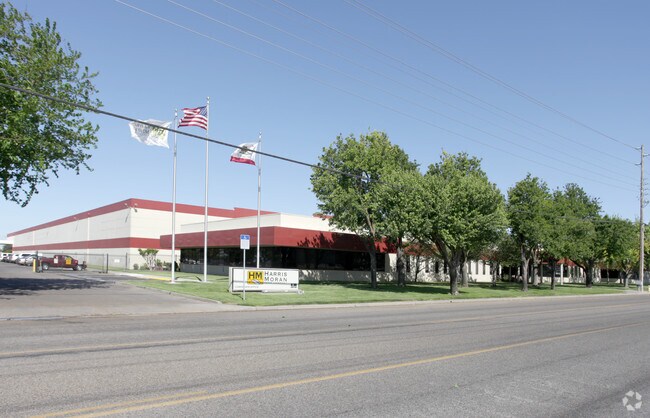
Property Detail
555 Codoni Ave
009-18-43
EQUIPMENT & SUPPLIES DD
Warehouse
Stanislaus
B and X Area of moderate flood hazard, usually the area between the limits of the 100-year and 500-year floods.
California
2025
15 AC
2025
Modesto
002002
Stockton/Modesto
225,013 SF
Modesto, CA
NEARBY LISTINGS FOR SALE OR LEASE
DEMOGRAPHICS near 555 Codoni Ave
1 mile
3 mile
5 mile
2025 Total Population
2,223
61,255
184,513
2030 Population
2,127
61,239
185,382
Pop Growth 2025-2030
(4.32%)
(0.03%)
+ 0.47%
Average Age
38
38
37
2025 Total Households
669
19,295
59,277
HH Growth 2025-2030
(4.93%)
(0.04%)
+ 0.49%
Median Household Inc
$53,000
$86,606
$81,967
Avg Household Size
3.20
3.10
3.00
2025 Avg HH Vehicles
2.00
2.00
2.00
Median Home Value
$353,378
$441,854
$446,986
Median Year Built
1973
1980
1978
Nearby Places
Map Layers
Map Styles
 Street
 Aerial
Layers
 Traffic
 Biking
Places
Listings with unknown addresses are not visible on the map
- Restaurants
- Banks
- Shops
- Fitness
- Groceries
PUBLIC TRANSPORTATION
AIRPORT
Stockton Metro
Drive
Walk
Distance
Stockton Metro
45 min
30.3 mi
Freight Ports
Port of Stockton
Drive
Walk
Distance
Port of Stockton
53 min
38.7 mi
Nearby Properties
Address
Land Use
TOTAL SIZE
Lot Size
Zoning
Address
Land Use
TOTAL SIZE
Lot Size
Zoning
517,008 SF
71.35 AC
Address
Land Use
TOTAL SIZE
Lot Size
Zoning
448,549 SF
58.48 AC
Address
Land Use
TOTAL SIZE
Lot Size
Zoning
1,225,202 SF
67.24 AC
MI
Address
Land Use
TOTAL SIZE
Lot Size
Zoning
154,264 SF
7.63 AC
Address
Land Use
TOTAL SIZE
Lot Size
Zoning
482,100 SF
21 AC
Address
Land Use
TOTAL SIZE
Lot Size
Zoning
192,858 SF
10.44 AC
Address
Land Use
TOTAL SIZE
Lot Size
Zoning
775,280 SF
30.42 AC
COUM
Address
Land Use
TOTAL SIZE
Lot Size
Zoning
327,227 SF
13.52 AC
MODM1
Address
Land Use
TOTAL SIZE
Lot Size
Zoning
476,580 SF
44.60 AC
Address
Land Use
TOTAL SIZE
Lot Size
Zoning
164,740 SF
9.35 AC
Address
Land Use
TOTAL SIZE
Lot Size
Zoning
98,140 SF
6.04 AC
Address
Land Use
TOTAL SIZE
Lot Size
Zoning
256,014 SF
19.38 AC
Address
Land Use
TOTAL SIZE
Lot Size
Zoning
165,196 SF
15.57 AC
Address
Land Use
TOTAL SIZE
Lot Size
Zoning
102,200 SF
9.85 AC
Address
Land Use
TOTAL SIZE
Lot Size
Zoning
447,488 SF
22.67 AC
Address
Land Use
TOTAL SIZE
Lot Size
Zoning
26,592 SF
77.55 AC
Address
Land Use
TOTAL SIZE
Lot Size
Zoning
318,687 SF
36.39 AC
COUM
Address
Land Use
TOTAL SIZE
Lot Size
Zoning
366,400 SF
23.90 AC
Address
Land Use
TOTAL SIZE
Lot Size
Zoning
174,524 SF
11.61 AC
M
Address
Land Use
TOTAL SIZE
Lot Size
Zoning
86,224 SF
22.84 AC
Address
Land Use
TOTAL SIZE
Lot Size
Zoning
149,756 SF
9.68 AC
Address
Land Use
TOTAL SIZE
Lot Size
Zoning
156,414 SF
6.57 AC
Address
Land Use
TOTAL SIZE
Lot Size
Zoning
392,796 SF
25.89 AC
COUM
Address
Land Use
TOTAL SIZE
Lot Size
Zoning
397,665 SF
15.05 AC
Address
Land Use
TOTAL SIZE
Lot Size
Zoning
144,256 SF
5.80 AC
COUM
Address
Land Use
TOTAL SIZE
Lot Size
Zoning
266,250 SF
8.88 AC
Address
Land Use
TOTAL SIZE
Lot Size
Zoning
261,267 SF
9.20 AC
Address
Land Use
TOTAL SIZE
Lot Size
Zoning
257,760 SF
8.72 AC
COUM
Address
Land Use
TOTAL SIZE
Lot Size
Zoning
50,396 SF
10.60 AC
Address
Land Use
TOTAL SIZE
Lot Size
Zoning
160,117 SF
8.91 AC
The World's #1 Commercial Real Estate Marketplace
Connect with us
© 2026 CoStar Group
The information above has been obtained from sources believed reliable. While we do not doubt its accuracy we have not verified it and make no guarantee, warranty or representation about it. It is your responsibility to independently confirm its accuracy and completeness. Any projections, opinions, assumptions, or estimates used are for example only and do not represent the current or future performance of the property. The value of this transaction to you depends on tax and other factors which should be evaluated by your tax, financial, and legal advisors. You and your advisors should conduct a careful, independent investigation of the property to determine to your satisfaction the suitability of the property for your needs.