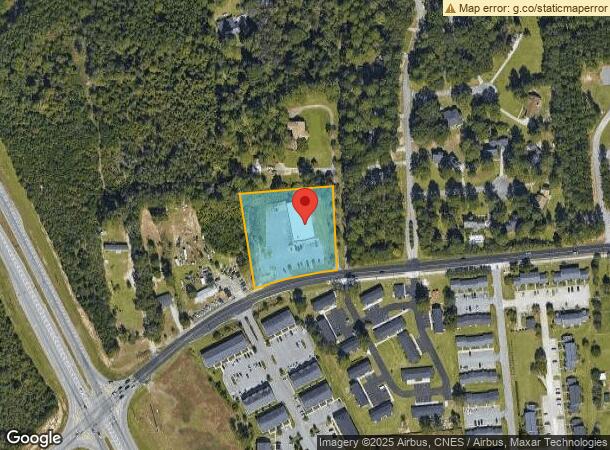
Property Record
555 E Main St, Statesboro, GA 30461

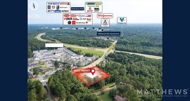
NEARBY LISTINGS FOR SALE OR LEASE
Property Detail
555 E Main St
MS82000011-000
Plantation Acres
Commercialnec
1.79 AC/E MAIN STREET/DOLLAR GENERAL
X
Bulloch
13031C0209D
Georgia
2024
1.79 AC
2025
Georgia South Area
110602
Other Market Areas
9,012 SF
Statesboro, GA
DEMOGRAPHICS near 555 E Main St
1 Mile
3 Mile
5 Mile
2024 Total Population
4,332
25,551
49,213
2029 Population
4,807
27,939
53,652
Pop Growth 2024-2029
+ 10.96%
+ 9.35%
+ 9.02%
Average Age
36
35
33
2024 Total Households
1,851
9,716
18,417
HH Growth 2024-2029
+ 11.62%
+ 10.33%
+ 9.80%
Median Household Inc
$35,382
$49,027
$50,495
Avg Household Size
2.30
2.30
2.40
2024 Avg HH Vehicles
1.00
2.00
2.00
Median Home Value
$160,857
$171,813
$192,067
Median Year Built
1993
1983
1991
Nearby Places
Map Layers
Map Styles
 Street
 Aerial
- Restaurants
- Banks
- Shops
- Fitness
- Groceries
SALE & LEASE HISTORY
LISTING DATE
SALE/LEASE

Mar 17, 2017
For Sale
Aug 26, 2024
For Sale
Aug 18, 2022
For Sale
Nearby Properties
Address
Land Use
TOTAL SIZE
Lot Size
Zoning
Address
Land Use
TOTAL SIZE
Lot Size
Zoning
15,334 SF
1.67 AC
CR
Address
Land Use
TOTAL SIZE
Lot Size
Zoning
250,037 SF
30.67 AC
O
Address
Land Use
TOTAL SIZE
Lot Size
Zoning
1,280 SF
792.45 AC
LI
Address
Land Use
TOTAL SIZE
Lot Size
Zoning
5.54 AC
EXPT
Address
Land Use
TOTAL SIZE
Lot Size
Zoning
41.09 AC
R3/R15
Address
Land Use
TOTAL SIZE
Lot Size
Zoning
146,137 SF
17.78 AC
CR
Address
Land Use
TOTAL SIZE
Lot Size
Zoning
3,659 SF
38.60 AC
R40
Address
Land Use
TOTAL SIZE
Lot Size
Zoning
950 SF
12.73 AC
PUD/R4
Address
Land Use
TOTAL SIZE
Lot Size
Zoning
153.74 AC
R40
Address
Land Use
TOTAL SIZE
Lot Size
Zoning
4,450 SF
26.60 AC
R4
Address
Land Use
TOTAL SIZE
Lot Size
Zoning
61,539 SF
2.50 AC
CR
Address
Land Use
TOTAL SIZE
Lot Size
Zoning
58,176 SF
2.10 AC
HOC
Address
Land Use
TOTAL SIZE
Lot Size
Zoning
13 AC
R20
Address
Land Use
TOTAL SIZE
Lot Size
Zoning
19.41 AC
R10/R15
Address
Land Use
TOTAL SIZE
Lot Size
Zoning
20.77 AC
R15
Address
Land Use
TOTAL SIZE
Lot Size
Zoning
13,820 SF
5.14 AC
CR
Address
Land Use
TOTAL SIZE
Lot Size
Zoning
1,668 SF
14.51 AC
R4
Address
Land Use
TOTAL SIZE
Lot Size
Zoning
3,195 SF
22.67 AC
PUD/R4
Address
Land Use
TOTAL SIZE
Lot Size
Zoning
64,614 SF
Address
Land Use
TOTAL SIZE
Lot Size
Zoning
190,382 SF
23.53 AC
CR
Address
Land Use
TOTAL SIZE
Lot Size
Zoning
4,248 SF
19.24 AC
R40
Address
Land Use
TOTAL SIZE
Lot Size
Zoning
52.59 AC
HC/R-80
Address
Land Use
TOTAL SIZE
Lot Size
Zoning
102,529 SF
18.07 AC
CR
Address
Land Use
TOTAL SIZE
Lot Size
Zoning
76,118 SF
12.31 AC
CR
Address
Land Use
TOTAL SIZE
Lot Size
Zoning
70,000 SF
12 AC
R4/HOC
Address
Land Use
TOTAL SIZE
Lot Size
Zoning
83,803 SF
14.40 AC
CR
Address
Land Use
TOTAL SIZE
Lot Size
Zoning
16,501 SF
1.47 AC
CR
Address
Land Use
TOTAL SIZE
Lot Size
Zoning
4,460 SF
6.99 AC
CR
Address
Land Use
TOTAL SIZE
Lot Size
Zoning
29,004 SF
5.39 AC
LI
Address
Land Use
TOTAL SIZE
Lot Size
Zoning
75,000 SF
19.30 AC
LI
The World's #1 Commercial Real Estate Marketplace
Connect with us
© 2026 CoStar Group
The information above has been obtained from sources believed reliable. While we do not doubt its accuracy we have not verified it and make no guarantee, warranty or representation about it. It is your responsibility to independently confirm its accuracy and completeness. Any projections, opinions, assumptions, or estimates used are for example only and do not represent the current or future performance of the property. The value of this transaction to you depends on tax and other factors which should be evaluated by your tax, financial, and legal advisors. You and your advisors should conduct a careful, independent investigation of the property to determine to your satisfaction the suitability of the property for your needs.