Property Record
558 Ashmun St, Sault Sainte Marie, MI 49783
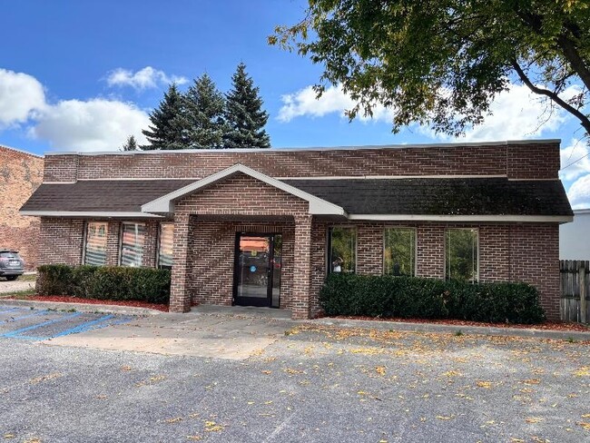

This Property Is For Sale
NEARBY LISTINGS FOR SALE OR LEASE
-
-
-
-
No Photo
-
View all Sault Sainte Marie listings for sale on LoopNet.com
Property Detail
558 Ashmun St
Sault Ste. Marie, MI
R H Carleton S Subd
051-008-013-00
R H CARLETON'S SUBD OF PLC NO 90; S 34 FT LOT 12 EXCL E 7 FT THEREOF AND LOT 13 ALSO W 50 FT LOT 14. (1990 008-014-50; 2007
Commercialnec
Chippewa
X
Michigan
26033C0501D
12-14
2024
16,945.23 AC
2025
Upper Peninsula
970300
Other Market Areas
DEMOGRAPHICS near 558 Ashmun St
1 Mile
3 Mile
5 Mile
2024 Total Population
7,046
11,781
14,088
2029 Population
6,937
11,603
13,909
Pop Growth 2024-2029
(1.55%)
(1.51%)
(1.27%)
Average Age
37
38
39
2024 Total Households
2,979
4,957
5,872
HH Growth 2024-2029
(1.71%)
(1.86%)
(1.65%)
Median Household Inc
$49,393
$52,166
$55,565
Avg Household Size
2.10
2.20
2.20
2024 Avg HH Vehicles
1.00
1.00
2.00
Median Home Value
$126,133
$128,533
$141,878
Median Year Built
1951
1961
1965
Nearby Places
Map Layers
Map Styles
 Street
 Aerial
- Restaurants
- Banks
- Shops
- Fitness
- Groceries
PUBLIC TRANSPORTATION
AIRPORT
Sault Ste Marie
DRIVE
WALK
Distance
Sault Ste Marie
29 min
15.1 mi
Freight Ports
Port Milwaukee
DRIVE
WALK
Distance
Port Milwaukee
474 min
400.6 mi
Nearby Properties
Address
Land Use
TOTAL SIZE
Lot Size
Zoning
Address
Land Use
TOTAL SIZE
Lot Size
Zoning
17.12 AC
RM2
Address
Land Use
TOTAL SIZE
Lot Size
Zoning
122.46 AC
SPLIT
Address
Land Use
TOTAL SIZE
Lot Size
Zoning
29.74 AC
B3
Address
Land Use
TOTAL SIZE
Lot Size
Zoning
29.76 AC
SPLIT
Address
Land Use
TOTAL SIZE
Lot Size
Zoning
10 AC
RM1
Address
Land Use
TOTAL SIZE
Lot Size
Zoning
Address
Land Use
TOTAL SIZE
Lot Size
Zoning
39,553.39 AC
B2
Address
Land Use
TOTAL SIZE
Lot Size
Zoning
32,496.51 AC
OS
Address
Land Use
TOTAL SIZE
Lot Size
Zoning
178,905.03 AC
RM2
Address
Land Use
TOTAL SIZE
Lot Size
Zoning
14.34 AC
B3
Address
Land Use
TOTAL SIZE
Lot Size
Zoning
101,279.33 AC
T
Address
Land Use
TOTAL SIZE
Lot Size
Zoning
4.07 AC
RM1
Address
Land Use
TOTAL SIZE
Lot Size
Zoning
119,400.70 AC
SPLIT
Address
Land Use
TOTAL SIZE
Lot Size
Zoning
10.24 AC
B3
Address
Land Use
TOTAL SIZE
Lot Size
Zoning
73,208 SF
13.59 AC
Address
Land Use
TOTAL SIZE
Lot Size
Zoning
49,594 SF
2.42 AC
Address
Land Use
TOTAL SIZE
Lot Size
Zoning
14.13 AC
B3
Address
Land Use
TOTAL SIZE
Lot Size
Zoning
17,080 SF
4.13 AC
Address
Land Use
TOTAL SIZE
Lot Size
Zoning
108,728.26 AC
B3
Address
Land Use
TOTAL SIZE
Lot Size
Zoning
Address
Land Use
TOTAL SIZE
Lot Size
Zoning
60,070.62 AC
B2
Address
Land Use
TOTAL SIZE
Lot Size
Zoning
41,960 SF
9.09 AC
Address
Land Use
TOTAL SIZE
Lot Size
Zoning
59,242.96 AC
B3
Address
Land Use
TOTAL SIZE
Lot Size
Zoning
59,722.13 AC
B3
Address
Land Use
TOTAL SIZE
Lot Size
Zoning
52,403.88 AC
B2
Address
Land Use
TOTAL SIZE
Lot Size
Zoning
120,010.55 AC
B3
Address
Land Use
TOTAL SIZE
Lot Size
Zoning
58,572 SF
5.56 AC
Address
Land Use
TOTAL SIZE
Lot Size
Zoning
89,735.66 AC
B3
Address
Land Use
TOTAL SIZE
Lot Size
Zoning
Address
Land Use
TOTAL SIZE
Lot Size
Zoning
2.76 AC
B3
The World's #1 Commercial Real Estate Marketplace
Connect with us
© 2026 CoStar Group
The information above has been obtained from sources believed reliable. While we do not doubt its accuracy we have not verified it and make no guarantee, warranty or representation about it. It is your responsibility to independently confirm its accuracy and completeness. Any projections, opinions, assumptions, or estimates used are for example only and do not represent the current or future performance of the property. The value of this transaction to you depends on tax and other factors which should be evaluated by your tax, financial, and legal advisors. You and your advisors should conduct a careful, independent investigation of the property to determine to your satisfaction the suitability of the property for your needs.