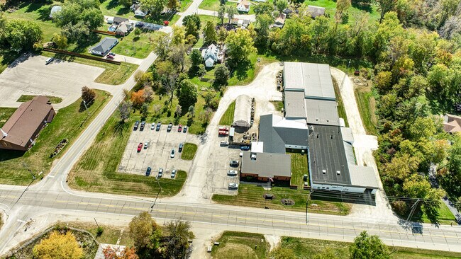
Property Record
5589 W National Rd, Springfield, OH 45504


NEARBY LISTINGS FOR SALE OR LEASE
-
-
View all Springfield listings for sale on LoopNet.com
Property Detail
5589 W National Rd
Springfield, OH
Tecumseh Heights
01-00600-03440-3034
PT N E PT S E QR
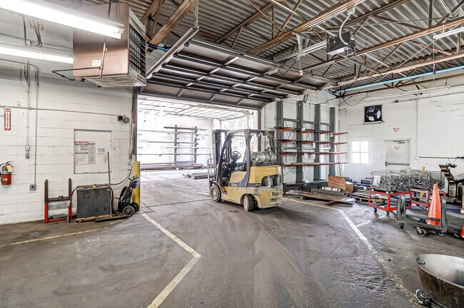
Industrialgeneral
Clark
X
Ohio
39023C0166E
34
2024
4.90 AC
2025
Northeast Dayton
001900
Cincinnati/Dayton
45,781 SF
DEMOGRAPHICS near 5589 W National Rd
1 Mile
3 Mile
5 Mile
2024 Total Population
1,159
8,796
31,510
2029 Population
1,121
8,742
31,318
Pop Growth 2024-2029
(3.28%)
(0.61%)
(0.61%)
Average Age
45
44
43
2024 Total Households
455
3,511
12,751
HH Growth 2024-2029
(3.30%)
(0.48%)
(0.60%)
Median Household Inc
$83,168
$79,014
$67,056
Avg Household Size
2.60
2.40
2.40
2024 Avg HH Vehicles
3.00
2.00
2.00
Median Home Value
$188,043
$192,521
$166,270
Median Year Built
1963
1968
1964
Nearby Places
Map Layers
Map Styles
 Street
 Aerial
- Restaurants
- Banks
- Shops
- Fitness
- Groceries
PUBLIC TRANSPORTATION
AIRPORT
James M Cox Dayton International
DRIVE
WALK
Distance
James M Cox Dayton International
29 min
22.2 mi
Freight Ports
Port Milwaukee
DRIVE
WALK
Distance
Port Milwaukee
447 min
389.3 mi
SALE & LEASE HISTORY
LISTING DATE
SALE/LEASE

Oct 14, 2022
For Sale
May 17, 2024
For Lease
Jun 16, 2025
For Sale
Nearby Properties
Address
Land Use
TOTAL SIZE
Lot Size
Zoning
Address
Land Use
TOTAL SIZE
Lot Size
Zoning
234,478 SF
59.28 AC
Address
Land Use
TOTAL SIZE
Lot Size
Zoning
6,495 SF
38.20 AC
Address
Land Use
TOTAL SIZE
Lot Size
Zoning
144,644 SF
38.20 AC
I-1
Address
Land Use
TOTAL SIZE
Lot Size
Zoning
103,589 SF
59.28 AC
Address
Land Use
TOTAL SIZE
Lot Size
Zoning
20,982 SF
19.65 AC
Address
Land Use
TOTAL SIZE
Lot Size
Zoning
84,432 SF
13.39 AC
I-1
Address
Land Use
TOTAL SIZE
Lot Size
Zoning
2.94 AC
Address
Land Use
TOTAL SIZE
Lot Size
Zoning
5,886 SF
12.93 AC
Address
Land Use
TOTAL SIZE
Lot Size
Zoning
52,710 SF
1.87 AC
Address
Land Use
TOTAL SIZE
Lot Size
Zoning
40,000 SF
10.41 AC
I-1
Address
Land Use
TOTAL SIZE
Lot Size
Zoning
265.13 AC
A-1
Address
Land Use
TOTAL SIZE
Lot Size
Zoning
24,440 SF
169.99 AC
A-1
Address
Land Use
TOTAL SIZE
Lot Size
Zoning
Address
Land Use
TOTAL SIZE
Lot Size
Zoning
4,356 SF
201.93 AC
A1
Address
Land Use
TOTAL SIZE
Lot Size
Zoning
202.42 AC
A-1
Address
Land Use
TOTAL SIZE
Lot Size
Zoning
102,224 SF
12.10 AC
Address
Land Use
TOTAL SIZE
Lot Size
Zoning
52,498 SF
20.32 AC
B-4
Address
Land Use
TOTAL SIZE
Lot Size
Zoning
7,304 SF
142.87 AC
A-1
Address
Land Use
TOTAL SIZE
Lot Size
Zoning
7,262 SF
88.50 AC
A-1
Address
Land Use
TOTAL SIZE
Lot Size
Zoning
3,488 SF
133.33 AC
A-1
Address
Land Use
TOTAL SIZE
Lot Size
Zoning
7,766 SF
89.49 AC
A-1
Address
Land Use
TOTAL SIZE
Lot Size
Zoning
139.92 AC
A-1
Address
Land Use
TOTAL SIZE
Lot Size
Zoning
5,760 SF
85 AC
A-1
Address
Land Use
TOTAL SIZE
Lot Size
Zoning
1,680 SF
125.30 AC
A-1
Address
Land Use
TOTAL SIZE
Lot Size
Zoning
22,970 SF
20.28 AC
A
Address
Land Use
TOTAL SIZE
Lot Size
Zoning
6.07 AC
A1
Address
Land Use
TOTAL SIZE
Lot Size
Zoning
3,588 SF
27.51 AC
Address
Land Use
TOTAL SIZE
Lot Size
Zoning
3,432 SF
106.22 AC
A-1
Address
Land Use
TOTAL SIZE
Lot Size
Zoning
2,476 SF
105.60 AC
A-1
Address
Land Use
TOTAL SIZE
Lot Size
Zoning
44,239 SF
15.92 AC
I-1S
The World's #1 Commercial Real Estate Marketplace
Connect with us
© 2025 CoStar Group
The information above has been obtained from sources believed reliable. While we do not doubt its accuracy we have not verified it and make no guarantee, warranty or representation about it. It is your responsibility to independently confirm its accuracy and completeness. Any projections, opinions, assumptions, or estimates used are for example only and do not represent the current or future performance of the property. The value of this transaction to you depends on tax and other factors which should be evaluated by your tax, financial, and legal advisors. You and your advisors should conduct a careful, independent investigation of the property to determine to your satisfaction the suitability of the property for your needs.