Property Record
5590 High St, Denver, CO 80216
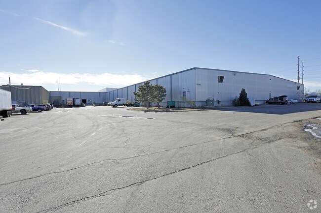
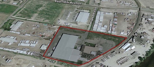

Property Detail
5590 High St
1825-11-4-02-001
SUB:WILHELM SUBD BLK:1
Warehouse
Adams
I3
Colorado
AE The base floodplain where base flood elevations are provided. AE Zones are now used on new format FIRMs instead of A1-A30 Zones.
6.16 AC
2024
Commerce City
2025
Denver
015000
Denver-Aurora-Centennial, CO
182,124 SF
NEARBY LISTINGS FOR SALE OR LEASE
DEMOGRAPHICS near 5590 High St
1 mile
3 mile
5 mile
2025 Total Population
2,709
80,416
393,884
2030 Population
3,112
84,168
406,099
Pop Growth 2025-2030
+ 14.88%
+ 4.67%
+ 3.10%
Average Age
38
36
37
2025 Total Households
922
30,157
174,746
HH Growth 2025-2030
+ 16.16%
+ 4.87%
+ 3.20%
Median Household Inc
$20,058
$90,702
$95,599
Avg Household Size
2.80
2.50
2.10
2025 Avg HH Vehicles
1.00
2.00
2.00
Median Home Value
$370,666
$502,123
$599,680
Median Year Built
2010
1972
1973
Nearby Places
Map Layers
Map Styles
 Street
 Aerial
Layers
 Traffic
 Biking
Places
Listings with unknown addresses are not visible on the map
- Restaurants
- Banks
- Shops
- Fitness
- Groceries
PUBLIC TRANSPORTATION
COMMUTER RAIL
48Th & Brighton-National Western Station Track 1 (Union Station to Eastlake & 124th Station - Regional Transportation District)
Drive
Walk
Distance
48Th & Brighton-National Western Station Track 1 (Union Station to Eastlake & 124th Station - Regional Transportation District)
7 min
2.2 mi
40Th & Colorado Station Track 2 (Union Station to Denver Airport Station - Regional Transportation District)
Drive
Walk
Distance
40Th & Colorado Station Track 2 (Union Station to Denver Airport Station - Regional Transportation District)
9 min
3.3 mi
AIRPORT
Denver International
Drive
Walk
Distance
Denver International
32 min
23.3 mi
Freight Ports
Tulsa Port Of Catoosa
Drive
Walk
Distance
Tulsa Port Of Catoosa
729 min
708.8 mi
SALE & LEASE HISTORY
LISTING DATE
SALE/LEASE

Mar 22, 2018
For Lease
Nearby Properties
Address
Land Use
TOTAL SIZE
Lot Size
Zoning
Address
Land Use
TOTAL SIZE
Lot Size
Zoning
396,741 SF
8.12 AC
A1
Address
Land Use
TOTAL SIZE
Lot Size
Zoning
552,279 SF
2.22 AC
C-RX
Address
Land Use
TOTAL SIZE
Lot Size
Zoning
294,950 SF
6.91 AC
C-RX-12
Address
Land Use
TOTAL SIZE
Lot Size
Zoning
352,600 SF
18.21 AC
I-B
Address
Land Use
TOTAL SIZE
Lot Size
Zoning
1.64 AC
CMP
Address
Land Use
TOTAL SIZE
Lot Size
Zoning
84,252 SF
0.37 AC
I-MX-8
Address
Land Use
TOTAL SIZE
Lot Size
Zoning
256,155 SF
3.84 AC
Address
Land Use
TOTAL SIZE
Lot Size
Zoning
237,753 SF
18.94 AC
U-SU-B1
Address
Land Use
TOTAL SIZE
Lot Size
Zoning
3,188 SF
81.17 AC
I-B
Address
Land Use
TOTAL SIZE
Lot Size
Zoning
140,328 SF
6.54 AC
PUD
Address
Land Use
TOTAL SIZE
Lot Size
Zoning
281,209 SF
1.66 AC
C-MX-12
Address
Land Use
TOTAL SIZE
Lot Size
Zoning
8.83 AC
I-B
Address
Land Use
TOTAL SIZE
Lot Size
Zoning
649,540 SF
33.65 AC
Address
Land Use
TOTAL SIZE
Lot Size
Zoning
25,000 SF
40.42 AC
I-A
Address
Land Use
TOTAL SIZE
Lot Size
Zoning
446,845 SF
10.43 AC
CMP-NWC-G
Address
Land Use
TOTAL SIZE
Lot Size
Zoning
238,888 SF
1.13 AC
C-MX-12
Address
Land Use
TOTAL SIZE
Lot Size
Zoning
134,729 SF
5.57 AC
Address
Land Use
TOTAL SIZE
Lot Size
Zoning
230,309 SF
0.79 AC
I-MX-8
Address
Land Use
TOTAL SIZE
Lot Size
Zoning
551,915 SF
25.76 AC
Address
Land Use
TOTAL SIZE
Lot Size
Zoning
599,680 SF
43.94 AC
Address
Land Use
TOTAL SIZE
Lot Size
Zoning
201,798 SF
0.71 AC
I-MX-5
Address
Land Use
TOTAL SIZE
Lot Size
Zoning
74,106 SF
3.95 AC
PUD
Address
Land Use
TOTAL SIZE
Lot Size
Zoning
470,539 SF
23.59 AC
Address
Land Use
TOTAL SIZE
Lot Size
Zoning
595,017 SF
11.62 AC
I-B
Address
Land Use
TOTAL SIZE
Lot Size
Zoning
116,502 SF
4.08 AC
Address
Land Use
TOTAL SIZE
Lot Size
Zoning
344,689 SF
11.77 AC
I-B
Address
Land Use
TOTAL SIZE
Lot Size
Zoning
110,878 SF
4.65 AC
Address
Land Use
TOTAL SIZE
Lot Size
Zoning
727,307 SF
38.44 AC
I-B
Address
Land Use
TOTAL SIZE
Lot Size
Zoning
6,626 SF
0.11 AC
C-RX
Address
Land Use
TOTAL SIZE
Lot Size
Zoning
94,213 SF
3.84 AC
A1
The World's #1 Commercial Real Estate Marketplace
Connect with us
© 2026 CoStar Group
The information above has been obtained from sources believed reliable. While we do not doubt its accuracy we have not verified it and make no guarantee, warranty or representation about it. It is your responsibility to independently confirm its accuracy and completeness. Any projections, opinions, assumptions, or estimates used are for example only and do not represent the current or future performance of the property. The value of this transaction to you depends on tax and other factors which should be evaluated by your tax, financial, and legal advisors. You and your advisors should conduct a careful, independent investigation of the property to determine to your satisfaction the suitability of the property for your needs.