Property Record
560 Magnolia Ave, Larkspur, CA 94939


Save to a Folder
{{folder.Name}}
{{folder.ListingIds.length}} Properties
{{folder.ListingIds.length}} Property
Create a New Folder
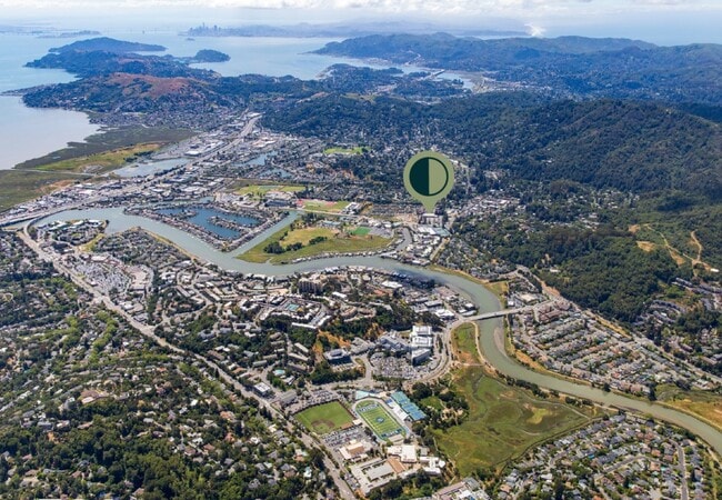
Property Detail
560 Magnolia Ave
022-110-47
MARIN
Commercialnec
California
C and X Area of minimal flood hazard, usually depicted on FIRMs as above the 500-year flood level.
2.16 AC
2025
San Rafael/Larkspur
2026
North Bay/Santa Rosa
120002
San Rafael, CA
27,385 SF
NEARBY LISTINGS FOR SALE OR LEASE
DEMOGRAPHICS near 560 Magnolia Ave
1 mile
3 mile
5 mile
2025 Total Population
14,113
82,877
144,637
2030 Population
13,983
81,837
142,780
Pop Growth 2025-2030
(0.92%)
(1.25%)
(1.28%)
Average Age
47
44
45
2025 Total Households
6,337
32,523
57,884
HH Growth 2025-2030
(0.93%)
(1.17%)
(1.25%)
Median Household Inc
$155,471
$138,274
$145,318
Avg Household Size
2.20
2.40
2.40
2025 Avg HH Vehicles
2.00
2.00
2.00
Median Home Value
$1,112,294
$1,122,099
$1,119,247
Median Year Built
1965
1962
1963
Nearby Places
Map Layers
Map Styles
 Street
 Aerial
Layers
 Traffic
 Biking
Places
Listings with unknown addresses are not visible on the map
- Restaurants
- Banks
- Shops
- Fitness
- Groceries
PUBLIC TRANSPORTATION
COMMUTER RAIL
Drive
Walk
Distance
8 min
2.8 mi
Drive
Walk
Distance
11 min
4.8 mi
AIRPORT
San Francisco International
Drive
Walk
Distance
San Francisco International
49 min
29.2 mi
Metro Oakland International
Drive
Walk
Distance
Metro Oakland International
47 min
32.4 mi
Nearby Properties
Address
Land Use
TOTAL SIZE
Lot Size
Zoning
Address
Land Use
TOTAL SIZE
Lot Size
Zoning
271,212 SF
15.87 AC
Address
Land Use
TOTAL SIZE
Lot Size
Zoning
217,791 SF
4.51 AC
Address
Land Use
TOTAL SIZE
Lot Size
Zoning
87,058 SF
1.33 AC
Address
Land Use
TOTAL SIZE
Lot Size
Zoning
Address
Land Use
TOTAL SIZE
Lot Size
Zoning
180,000 SF
15.92 AC
Address
Land Use
TOTAL SIZE
Lot Size
Zoning
132,969 SF
9.09 AC
Address
Land Use
TOTAL SIZE
Lot Size
Zoning
91,151 SF
3.15 AC
Address
Land Use
TOTAL SIZE
Lot Size
Zoning
147,502 SF
1.02 AC
Address
Land Use
TOTAL SIZE
Lot Size
Zoning
218,521 SF
26.79 AC
Address
Land Use
TOTAL SIZE
Lot Size
Zoning
12.57 AC
Address
Land Use
TOTAL SIZE
Lot Size
Zoning
127,504 SF
8.49 AC
Address
Land Use
TOTAL SIZE
Lot Size
Zoning
119,061 SF
5.90 AC
Address
Land Use
TOTAL SIZE
Lot Size
Zoning
15.91 AC
SPD
Address
Land Use
TOTAL SIZE
Lot Size
Zoning
94,745 SF
1.46 AC
Address
Land Use
TOTAL SIZE
Lot Size
Zoning
234,922 SF
6 AC
Address
Land Use
TOTAL SIZE
Lot Size
Zoning
81,894 SF
5.91 AC
Address
Land Use
TOTAL SIZE
Lot Size
Zoning
119,185 SF
4.31 AC
Address
Land Use
TOTAL SIZE
Lot Size
Zoning
109,944 SF
5.73 AC
Address
Land Use
TOTAL SIZE
Lot Size
Zoning
84,245 SF
2.62 AC
Address
Land Use
TOTAL SIZE
Lot Size
Zoning
97,410 SF
5.97 AC
Address
Land Use
TOTAL SIZE
Lot Size
Zoning
11,830 SF
0.65 AC
Address
Land Use
TOTAL SIZE
Lot Size
Zoning
100,900 SF
4.32 AC
Address
Land Use
TOTAL SIZE
Lot Size
Zoning
138,861 SF
15.83 AC
Address
Land Use
TOTAL SIZE
Lot Size
Zoning
82,206 SF
3.67 AC
Address
Land Use
TOTAL SIZE
Lot Size
Zoning
Address
Land Use
TOTAL SIZE
Lot Size
Zoning
54,189 SF
4.80 AC
Address
Land Use
TOTAL SIZE
Lot Size
Zoning
75,629 SF
2.80 AC
Address
Land Use
TOTAL SIZE
Lot Size
Zoning
2.53 AC
Address
Land Use
TOTAL SIZE
Lot Size
Zoning
66,700 SF
0.99 AC
The World's #1 Commercial Real Estate Marketplace
Connect with us
© 2026 CoStar Group
The information above has been obtained from sources believed reliable. While we do not doubt its accuracy we have not verified it and make no guarantee, warranty or representation about it. It is your responsibility to independently confirm its accuracy and completeness. Any projections, opinions, assumptions, or estimates used are for example only and do not represent the current or future performance of the property. The value of this transaction to you depends on tax and other factors which should be evaluated by your tax, financial, and legal advisors. You and your advisors should conduct a careful, independent investigation of the property to determine to your satisfaction the suitability of the property for your needs.