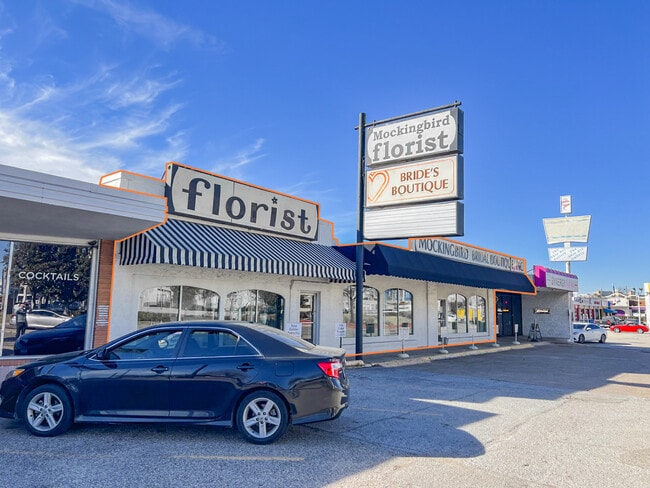
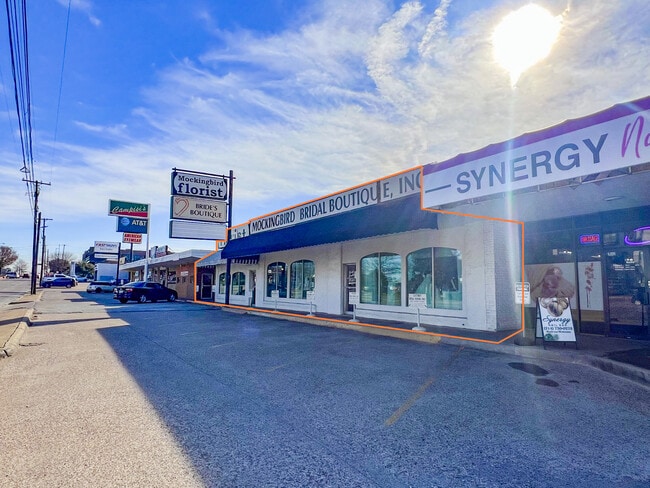
Property Record
5602 E Mockingbird Ln, Dallas, TX 75206

Current Lease Availabilities
Property Detail
5602 E Mockingbird Ln
00000238258000000
BLKS A/2897 & I/2900 TR 21 ACS 0.1538 CALC VOL89054/2552 EX111888 CO-DALLAS 2897 00A 00000 1002897 00A
Stripcommercialcenter
DALLAS
Z59
Texas
B and X Area of moderate flood hazard, usually the area between the limits of the 100-year and 500-year floods.
0.15 AC
2024
Lakewood
2025
Dallas/Ft Worth
000300
Dallas-Fort Worth-Arlington, TX
5,050 SF
NEARBY LISTINGS FOR SALE OR LEASE
DEMOGRAPHICS near 5602 E Mockingbird Ln
1 mile
3 mile
5 mile
2024 Total Population
21,397
211,920
438,282
2029 Population
22,111
220,383
456,294
Pop Growth 2024-2029
+ 3.34%
+ 3.99%
+ 4.11%
Average Age
36
37
38
2024 Total Households
10,653
104,272
212,349
HH Growth 2024-2029
+ 3.55%
+ 4.15%
+ 4.37%
Median Household Inc
$105,019
$99,945
$94,039
Avg Household Size
1.90
2.00
2.00
2024 Avg HH Vehicles
2.00
2.00
2.00
Median Home Value
$757,947
$812,787
$694,787
Median Year Built
1986
1986
1987
Nearby Places
Map Layers
Map Styles
 Street
 Aerial
Transit
 Traffic
 Biking
Places
Listings with unknown addresses are not visible on the map
- Restaurants
- Banks
- Shops
- Fitness
- Groceries
PUBLIC TRANSPORTATION
TRANSIT/SUBWAY
Smu/Mockingbird Station (DART LIGHT RAIL - BLUE LINE - Dallas Area Rapid Transit (DART), DART LIGHT RAIL - ORANGE LINE - Dallas Area Rapid Transit (DART), DART LIGHT RAIL - RED LINE - Dallas Area Rapid Transit (DART))
Drive
Walk
Distance
Smu/Mockingbird Station (DART LIGHT RAIL - BLUE LINE - Dallas Area Rapid Transit (DART), DART LIGHT RAIL - ORANGE LINE - Dallas Area Rapid Transit (DART), DART LIGHT RAIL - RED LINE - Dallas Area Rapid Transit (DART))
1 min
5 min
0.3 mi
COMMUTER RAIL
Victory Station (DART LIGHT RAIL - GREEN LINE - Dallas Area Rapid Transit (DART), DART LIGHT RAIL - ORANGE LINE - Dallas Area Rapid Transit (DART), TRINITY RAILWAY - Dallas Area Rapid Transit (DART))
Drive
Walk
Distance
Victory Station (DART LIGHT RAIL - GREEN LINE - Dallas Area Rapid Transit (DART), DART LIGHT RAIL - ORANGE LINE - Dallas Area Rapid Transit (DART), TRINITY RAILWAY - Dallas Area Rapid Transit (DART))
8 min
5.2 mi
Medical/Market Ctr Station (TRINITY RAILWAY - Dallas Area Rapid Transit (DART))
Drive
Walk
Distance
Medical/Market Ctr Station (TRINITY RAILWAY - Dallas Area Rapid Transit (DART))
12 min
6.8 mi
AIRPORT
Dallas Love Field
Drive
Walk
Distance
Dallas Love Field
12 min
5.1 mi
Dallas-Fort Worth International
Drive
Walk
Distance
Dallas-Fort Worth International
32 min
24.4 mi
Freight Ports
Port of Shreveport
Drive
Walk
Distance
Port of Shreveport
214 min
197.0 mi
Nearby Properties
Address
Land Use
TOTAL SIZE
Lot Size
Zoning
Address
Land Use
TOTAL SIZE
Lot Size
Zoning
1,634,356 SF
92.90 AC
Z421
Address
Land Use
TOTAL SIZE
Lot Size
Zoning
4,157,377 SF
76.79 AC
Z248
Address
Land Use
TOTAL SIZE
Lot Size
Zoning
858,872 SF
23.90 AC
Z421
Address
Land Use
TOTAL SIZE
Lot Size
Zoning
299,170 SF
9.71 AC
Z97
Address
Land Use
TOTAL SIZE
Lot Size
Zoning
502,529 SF
3.08 AC
Z239
Address
Land Use
TOTAL SIZE
Lot Size
Zoning
100 SF
27.05 AC
Z421
Address
Land Use
TOTAL SIZE
Lot Size
Zoning
226,331 SF
1.12 AC
Address
Land Use
TOTAL SIZE
Lot Size
Zoning
77.76 AC
Z239
Address
Land Use
TOTAL SIZE
Lot Size
Zoning
812,701 SF
3.73 AC
Address
Land Use
TOTAL SIZE
Lot Size
Zoning
2,695,010 SF
8.69 AC
Z239
Address
Land Use
TOTAL SIZE
Lot Size
Zoning
545,752 SF
1.33 AC
Z239
Address
Land Use
TOTAL SIZE
Lot Size
Zoning
875,990 SF
4.30 AC
Z239
Address
Land Use
TOTAL SIZE
Lot Size
Zoning
763,340 SF
8.31 AC
Z165
Address
Land Use
TOTAL SIZE
Lot Size
Zoning
447,418 SF
5.69 AC
Z236
Address
Land Use
TOTAL SIZE
Lot Size
Zoning
446,593 SF
0.93 AC
Address
Land Use
TOTAL SIZE
Lot Size
Zoning
146,302 SF
5.66 AC
Z60
Address
Land Use
TOTAL SIZE
Lot Size
Zoning
814,976 SF
8.72 AC
Z151
Address
Land Use
TOTAL SIZE
Lot Size
Zoning
662,911 SF
4.36 AC
Z239
Address
Land Use
TOTAL SIZE
Lot Size
Zoning
801,209 SF
1.57 AC
Z239
Address
Land Use
TOTAL SIZE
Lot Size
Zoning
595,955 SF
1.42 AC
Z239
Address
Land Use
TOTAL SIZE
Lot Size
Zoning
395,377 SF
14.61 AC
Z163
Address
Land Use
TOTAL SIZE
Lot Size
Zoning
601,951 SF
2.10 AC
Z239
Address
Land Use
TOTAL SIZE
Lot Size
Zoning
474,563 SF
2.42 AC
Z239
Address
Land Use
TOTAL SIZE
Lot Size
Zoning
749,138 SF
2.17 AC
Z239
Address
Land Use
TOTAL SIZE
Lot Size
Zoning
735,000 SF
2.05 AC
Z239
Address
Land Use
TOTAL SIZE
Lot Size
Zoning
335,752 SF
1.24 AC
Z239
Address
Land Use
TOTAL SIZE
Lot Size
Zoning
2,948 SF
25.35 AC
Z164
Address
Land Use
TOTAL SIZE
Lot Size
Zoning
674,474 SF
18.81 AC
Z164
Address
Land Use
TOTAL SIZE
Lot Size
Zoning
776,707 SF
8.47 AC
Address
Land Use
TOTAL SIZE
Lot Size
Zoning
240,205 SF
1.24 AC
The World's #1 Commercial Real Estate Marketplace
Connect with us
© 2026 CoStar Group
The information above has been obtained from sources believed reliable. While we do not doubt its accuracy we have not verified it and make no guarantee, warranty or representation about it. It is your responsibility to independently confirm its accuracy and completeness. Any projections, opinions, assumptions, or estimates used are for example only and do not represent the current or future performance of the property. The value of this transaction to you depends on tax and other factors which should be evaluated by your tax, financial, and legal advisors. You and your advisors should conduct a careful, independent investigation of the property to determine to your satisfaction the suitability of the property for your needs.