Property Record
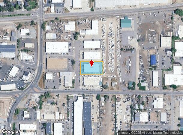
5612 Kendall Ct, Arvada, CO 80002
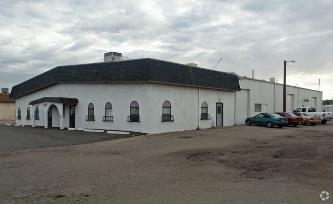
This Property Is For Sale
Current Lease Availabilities
NEARBY LISTINGS FOR SALE OR LEASE
Property Detail
5612 Kendall Ct
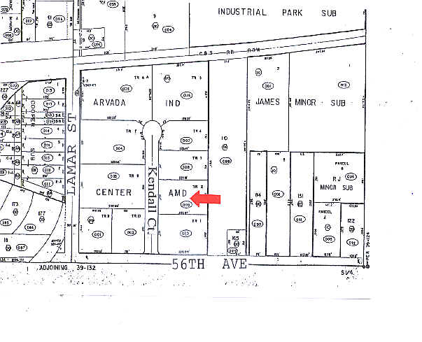
39-123-09-009
Arvada Industrial Center Amd
Industrialgeneral
SECTION 12 TOWNSHIP 03 RANGE 69 SUBDIVISIONCD 050000 SUBDIVISIONNAME ARVADA INDUSTRIAL CENTER AMD BLOCK 002 LOT SIZE: 29185 TRACT VALUE: .670
X
Jefferson
08059C0212F
Colorado
2023
0.67 AC
2024
Northwest Denver
010406
Denver
12,156 SF
Denver-Aurora-Centennial, CO
DEMOGRAPHICS near 5612 Kendall Ct
1 Mile
3 Mile
5 Mile
2024 Total Population
10,764
131,626
374,531
2029 Population
10,688
132,066
378,884
Pop Growth 2024-2029
(0.71%)
+ 0.33%
+ 1.16%
Average Age
38
40
39
2024 Total Households
4,590
55,746
162,379
HH Growth 2024-2029
(0.94%)
+ 0.20%
+ 1.15%
Median Household Inc
$63,939
$80,603
$82,613
Avg Household Size
2.30
2.30
2.20
2024 Avg HH Vehicles
2.00
2.00
2.00
Median Home Value
$423,507
$490,883
$503,504
Median Year Built
1972
1968
1974
Nearby Places
Map Layers
Map Styles
 Street
 Aerial
- Restaurants
- Banks
- Shops
- Fitness
- Groceries
PUBLIC TRANSPORTATION
COMMUTER RAIL
DRIVE
WALK
Distance
3 min
18 min
0.9 mi
DRIVE
WALK
Distance
4 min
19 min
1.0 mi
AIRPORT
Denver International
DRIVE
WALK
Distance
Denver International
37 min
27.8 mi
Nearby Properties
Address
Land Use
TOTAL SIZE
Lot Size
Zoning
Address
Land Use
TOTAL SIZE
Lot Size
Zoning
860,132 SF
68.50 AC
R-5
Address
Land Use
TOTAL SIZE
Lot Size
Zoning
138,770 SF
4.64 AC
Address
Land Use
TOTAL SIZE
Lot Size
Zoning
398,180 SF
33.31 AC
R1C
Address
Land Use
TOTAL SIZE
Lot Size
Zoning
111,673 SF
29.06 AC
Address
Land Use
TOTAL SIZE
Lot Size
Zoning
105,600 SF
1.31 AC
Address
Land Use
TOTAL SIZE
Lot Size
Zoning
390,764 SF
20.19 AC
Address
Land Use
TOTAL SIZE
Lot Size
Zoning
65,336 SF
2.86 AC
Address
Land Use
TOTAL SIZE
Lot Size
Zoning
298,150 SF
24.21 AC
Address
Land Use
TOTAL SIZE
Lot Size
Zoning
283,572 SF
17.76 AC
Address
Land Use
TOTAL SIZE
Lot Size
Zoning
69,537 SF
4.49 AC
Address
Land Use
TOTAL SIZE
Lot Size
Zoning
6,731 SF
80.77 AC
Address
Land Use
TOTAL SIZE
Lot Size
Zoning
27,921 SF
0.29 AC
C-MX-5
Address
Land Use
TOTAL SIZE
Lot Size
Zoning
62,025 SF
2.49 AC
R4
Address
Land Use
TOTAL SIZE
Lot Size
Zoning
436,238 SF
13.94 AC
Address
Land Use
TOTAL SIZE
Lot Size
Zoning
310,267 SF
1.69 AC
C-MX
Address
Land Use
TOTAL SIZE
Lot Size
Zoning
142,635 SF
6.84 AC
U-SU-B1
Address
Land Use
TOTAL SIZE
Lot Size
Zoning
389,561 SF
10.73 AC
Address
Land Use
TOTAL SIZE
Lot Size
Zoning
262,699 SF
13.10 AC
A2
Address
Land Use
TOTAL SIZE
Lot Size
Zoning
76,078 SF
6.64 AC
U-SU-C
Address
Land Use
TOTAL SIZE
Lot Size
Zoning
87,567 SF
14.98 AC
R-5
Address
Land Use
TOTAL SIZE
Lot Size
Zoning
115,719 SF
5.93 AC
Address
Land Use
TOTAL SIZE
Lot Size
Zoning
149,115 SF
18 AC
Address
Land Use
TOTAL SIZE
Lot Size
Zoning
307,377 SF
15.12 AC
Address
Land Use
TOTAL SIZE
Lot Size
Zoning
30,474 SF
1.20 AC
Address
Land Use
TOTAL SIZE
Lot Size
Zoning
163,361 SF
17.09 AC
Address
Land Use
TOTAL SIZE
Lot Size
Zoning
91,734 SF
9.69 AC
Address
Land Use
TOTAL SIZE
Lot Size
Zoning
83,675 SF
13.43 AC
R2
Address
Land Use
TOTAL SIZE
Lot Size
Zoning
73,269 SF
3.72 AC
U-SU-B1
Address
Land Use
TOTAL SIZE
Lot Size
Zoning
144,325 SF
13.22 AC
Address
Land Use
TOTAL SIZE
Lot Size
Zoning
114,348 SF
3 AC
The World's #1 Commercial Real Estate Marketplace
Connect with us
© 2026 CoStar Group
The information above has been obtained from sources believed reliable. While we do not doubt its accuracy we have not verified it and make no guarantee, warranty or representation about it. It is your responsibility to independently confirm its accuracy and completeness. Any projections, opinions, assumptions, or estimates used are for example only and do not represent the current or future performance of the property. The value of this transaction to you depends on tax and other factors which should be evaluated by your tax, financial, and legal advisors. You and your advisors should conduct a careful, independent investigation of the property to determine to your satisfaction the suitability of the property for your needs.