Property Record
5612 S Parker Rd, Aurora, CO 80015

NEARBY LISTINGS FOR SALE OR LEASE
Property Detail
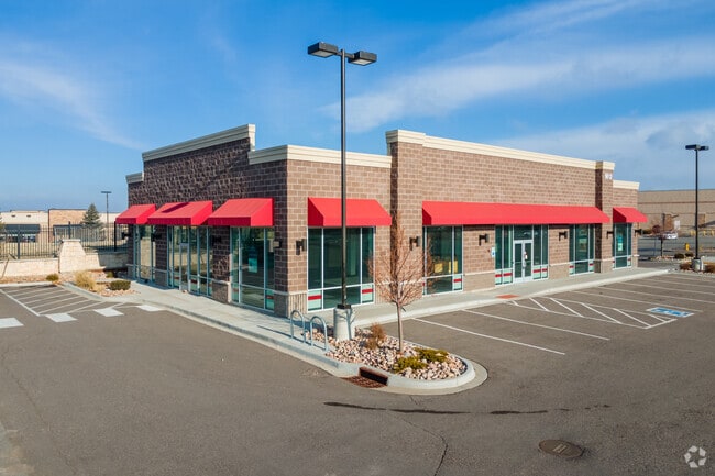
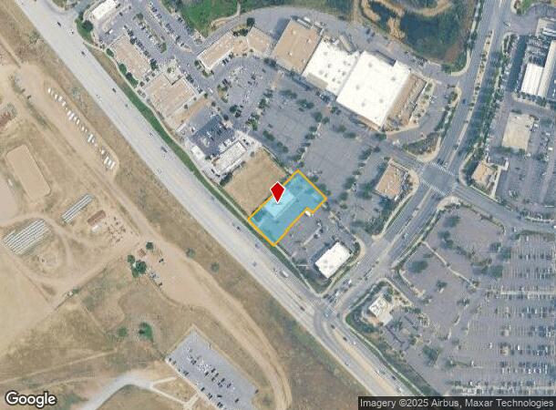
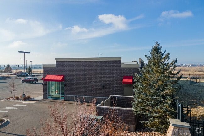
5612 S Parker Rd
Denver-Aurora-Centennial, CO
Pioneer Hills Subdivision Flg No 11
2073-18-4-06-001
TOWNSHIP 5S MAPPLATB 482 MAPPLATP 42 SUBDIVISIONCD 050186 SUBDIVISIONNAME PIONEER HILLS SUBDIVISION FLG NO 11 BLOCK 001 LOT 001 LOT 1 BLK 1 PIONEER HILLS SUB FLG NO 11 EX M/RS
Restaurantbuilding
Arapahoe
X
Colorado
08005C0477L
1
2024
0.64 AC
2025
Southeast
085700
Denver
4,940 SF
DEMOGRAPHICS near 5612 S Parker Rd
1 mile
3 mile
5 mile
2024 Total Population
9,838
87,439
287,529
2029 Population
9,844
86,894
289,733
Pop Growth 2024-2029
+ 0.06%
(0.62%)
+ 0.77%
Average Age
43
39
39
2024 Total Households
3,564
31,568
110,981
HH Growth 2024-2029
+ 0.03%
(0.64%)
+ 0.89%
Median Household Inc
$133,536
$103,320
$90,784
Avg Household Size
2.70
2.70
2.50
2024 Avg HH Vehicles
2.00
2.00
2.00
Median Home Value
$672,894
$493,442
$461,484
Median Year Built
1994
1988
1988
Nearby Places
Map Layers
Map Styles
 Street
 Aerial
Transit
 Traffic
 Biking
Places
Listings with unknown addresses are not visible on the map
- Restaurants
- Banks
- Shops
- Fitness
- Groceries
PUBLIC TRANSPORTATION
AIRPORT
Denver International
Drive
Walk
Distance
Denver International
33 min
25.2 mi
SALE & LEASE HISTORY
LISTING DATE
SALE/LEASE

Sep 24, 2016
For Sale
Sep 24, 2016
For Sale
May 07, 2021
For Sale
Mar 03, 2020
For Sale
Jan 07, 2019
For Lease
Nearby Properties
Address
Land Use
TOTAL SIZE
Lot Size
Zoning
Address
Land Use
TOTAL SIZE
Lot Size
Zoning
234,214 SF
5.23 AC
Address
Land Use
TOTAL SIZE
Lot Size
Zoning
280,586 SF
60.97 AC
RPD
Address
Land Use
TOTAL SIZE
Lot Size
Zoning
284,862 SF
23.37 AC
PUD
Address
Land Use
TOTAL SIZE
Lot Size
Zoning
525,600 SF
57.90 AC
Address
Land Use
TOTAL SIZE
Lot Size
Zoning
246,768 SF
12.37 AC
PUD
Address
Land Use
TOTAL SIZE
Lot Size
Zoning
134,316 SF
26.52 AC
Address
Land Use
TOTAL SIZE
Lot Size
Zoning
216,853 SF
5.42 AC
PUD
Address
Land Use
TOTAL SIZE
Lot Size
Zoning
103,811 SF
6.36 AC
RPD
Address
Land Use
TOTAL SIZE
Lot Size
Zoning
304,620 SF
23.95 AC
AMU
Address
Land Use
TOTAL SIZE
Lot Size
Zoning
107,760 SF
5.41 AC
AMU
Address
Land Use
TOTAL SIZE
Lot Size
Zoning
253,296 SF
16.41 AC
Address
Land Use
TOTAL SIZE
Lot Size
Zoning
217,273 SF
18.28 AC
Address
Land Use
TOTAL SIZE
Lot Size
Zoning
171,600 SF
10.32 AC
AA2
Address
Land Use
TOTAL SIZE
Lot Size
Zoning
281,429 SF
22.55 AC
PUD
Address
Land Use
TOTAL SIZE
Lot Size
Zoning
337,765 SF
23.46 AC
Address
Land Use
TOTAL SIZE
Lot Size
Zoning
91.37 AC
Address
Land Use
TOTAL SIZE
Lot Size
Zoning
166,431 SF
19.37 AC
Address
Land Use
TOTAL SIZE
Lot Size
Zoning
122,965 SF
12.30 AC
RPD
Address
Land Use
TOTAL SIZE
Lot Size
Zoning
12,726 SF
17.94 AC
Address
Land Use
TOTAL SIZE
Lot Size
Zoning
132,300 SF
11.09 AC
AMU
Address
Land Use
TOTAL SIZE
Lot Size
Zoning
288,737 SF
26.40 AC
AMU
Address
Land Use
TOTAL SIZE
Lot Size
Zoning
150,000 SF
10.83 AC
AA2
Address
Land Use
TOTAL SIZE
Lot Size
Zoning
106,000 SF
27.41 AC
Address
Land Use
TOTAL SIZE
Lot Size
Zoning
105,809 SF
48.79 AC
Address
Land Use
TOTAL SIZE
Lot Size
Zoning
157,906 SF
14.47 AC
Address
Land Use
TOTAL SIZE
Lot Size
Zoning
145,176 SF
11.11 AC
PUD
Address
Land Use
TOTAL SIZE
Lot Size
Zoning
119,074 SF
9.38 AC
AMU
Address
Land Use
TOTAL SIZE
Lot Size
Zoning
78,769 SF
13.28 AC
AMU
Address
Land Use
TOTAL SIZE
Lot Size
Zoning
337,565 SF
17.11 AC
Address
Land Use
TOTAL SIZE
Lot Size
Zoning
122,616 SF
11.46 AC
AMU
The World's #1 Commercial Real Estate Marketplace
Connect with us
© 2026 CoStar Group
The information above has been obtained from sources believed reliable. While we do not doubt its accuracy we have not verified it and make no guarantee, warranty or representation about it. It is your responsibility to independently confirm its accuracy and completeness. Any projections, opinions, assumptions, or estimates used are for example only and do not represent the current or future performance of the property. The value of this transaction to you depends on tax and other factors which should be evaluated by your tax, financial, and legal advisors. You and your advisors should conduct a careful, independent investigation of the property to determine to your satisfaction the suitability of the property for your needs.