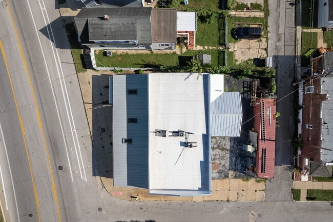
Property Record
5634 Morganford Rd, Saint Louis, MO 63116


Current Lease Availabilities
NEARBY LISTINGS FOR SALE OR LEASE
Property Detail
5634 Morganford Rd
St. Louis, MO-IL
Burgen Pl Addn
5502-00-0840-0
C. B. 5502 BURGEN 78 FT 7 3/4 IN / 93 FT 4 9/16 IN X 61 FT 7 1/16 IN / 59 FT 6 1/4 IN BURGEN PL ADDN LOTS 3 & 4
Commercialnec
St. Louis City
X
Missouri
2903850084C
3-4
2024
0.12 AC
2025
St Louis City
101300
St. Louis
2,333 SF
DEMOGRAPHICS near 5634 Morganford Rd
1 Mile
3 Mile
5 Mile
2024 Total Population
20,495
138,651
282,710
2029 Population
18,820
129,254
267,965
Pop Growth 2024-2029
(8.17%)
(6.78%)
(5.22%)
Average Age
41
40
40
2024 Total Households
9,625
65,172
133,920
HH Growth 2024-2029
(8.04%)
(6.83%)
(5.36%)
Median Household Inc
$55,828
$57,082
$59,415
Avg Household Size
2.10
2.10
2.00
2024 Avg HH Vehicles
1.00
1.00
1.00
Median Home Value
$162,594
$175,639
$192,417
Median Year Built
1946
1947
1948
Nearby Places
Map Layers
Map Styles
 Street
 Aerial
- Restaurants
- Banks
- Shops
- Fitness
- Groceries
PUBLIC TRANSPORTATION
COMMUTER RAIL
Shrewsbury-Lansdowne (Shrewsbury-Lansdowne I-44 Emerson Park - St. Louis MetroLink (MetroLink))
DRIVE
WALK
Distance
Shrewsbury-Lansdowne (Shrewsbury-Lansdowne I-44 Emerson Park - St. Louis MetroLink (MetroLink))
11 min
4.2 mi
DRIVE
WALK
Distance
14 min
5.4 mi
AIRPORT
St Louis Lambert International
DRIVE
WALK
Distance
St Louis Lambert International
32 min
19.0 mi
Scott AFB/Midamerica St Louis
DRIVE
WALK
Distance
Scott AFB/Midamerica St Louis
50 min
32.1 mi
Nearby Properties
Address
Land Use
TOTAL SIZE
Lot Size
Zoning
Address
Land Use
TOTAL SIZE
Lot Size
Zoning
0.92 AC
A
Address
Land Use
TOTAL SIZE
Lot Size
Zoning
5.61 AC
A
Address
Land Use
TOTAL SIZE
Lot Size
Zoning
229.57 AC
B
Address
Land Use
TOTAL SIZE
Lot Size
Zoning
177.77 AC
A
Address
Land Use
TOTAL SIZE
Lot Size
Zoning
57.77 AC
A
Address
Land Use
TOTAL SIZE
Lot Size
Zoning
124,890 SF
11.91 AC
J
Address
Land Use
TOTAL SIZE
Lot Size
Zoning
22.44 AC
A
Address
Land Use
TOTAL SIZE
Lot Size
Zoning
23.21 AC
A
Address
Land Use
TOTAL SIZE
Lot Size
Zoning
106,148 SF
13.01 AC
53C-2
Address
Land Use
TOTAL SIZE
Lot Size
Zoning
261,362 SF
17.19 AC
R6
Address
Land Use
TOTAL SIZE
Lot Size
Zoning
50.67 AC
A
Address
Land Use
TOTAL SIZE
Lot Size
Zoning
17.93 AC
R5
Address
Land Use
TOTAL SIZE
Lot Size
Zoning
433,028 SF
32.35 AC
A
Address
Land Use
TOTAL SIZE
Lot Size
Zoning
124,541 SF
13.07 AC
G
Address
Land Use
TOTAL SIZE
Lot Size
Zoning
54,790 SF
0.87 AC
B
Address
Land Use
TOTAL SIZE
Lot Size
Zoning
122,278 SF
10.83 AC
F
Address
Land Use
TOTAL SIZE
Lot Size
Zoning
89,094 SF
9.91 AC
G
Address
Land Use
TOTAL SIZE
Lot Size
Zoning
219,361 SF
9.36 AC
M1
Address
Land Use
TOTAL SIZE
Lot Size
Zoning
Address
Land Use
TOTAL SIZE
Lot Size
Zoning
6.99 AC
D
Address
Land Use
TOTAL SIZE
Lot Size
Zoning
9.33 AC
R5
Address
Land Use
TOTAL SIZE
Lot Size
Zoning
140,933 SF
4.97 AC
F
Address
Land Use
TOTAL SIZE
Lot Size
Zoning
260,617 SF
10.46 AC
M1
Address
Land Use
TOTAL SIZE
Lot Size
Zoning
Address
Land Use
TOTAL SIZE
Lot Size
Zoning
15.97 AC
A
Address
Land Use
TOTAL SIZE
Lot Size
Zoning
39.88 AC
A
Address
Land Use
TOTAL SIZE
Lot Size
Zoning
264,575 SF
1.50 AC
K
Address
Land Use
TOTAL SIZE
Lot Size
Zoning
31.91 AC
A
Address
Land Use
TOTAL SIZE
Lot Size
Zoning
15.84 AC
R5
Address
Land Use
TOTAL SIZE
Lot Size
Zoning
88,456 SF
10.48 AC
H
The World's #1 Commercial Real Estate Marketplace
Connect with us
© 2026 CoStar Group
The information above has been obtained from sources believed reliable. While we do not doubt its accuracy we have not verified it and make no guarantee, warranty or representation about it. It is your responsibility to independently confirm its accuracy and completeness. Any projections, opinions, assumptions, or estimates used are for example only and do not represent the current or future performance of the property. The value of this transaction to you depends on tax and other factors which should be evaluated by your tax, financial, and legal advisors. You and your advisors should conduct a careful, independent investigation of the property to determine to your satisfaction the suitability of the property for your needs.