Property Record
564 S Grove Street Ext, Lincolnton, NC 28092
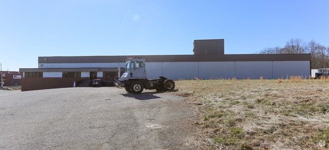


This Property Is For Sale
NEARBY LISTINGS FOR SALE OR LEASE
Property Detail
564 S Grove Street Ext
Charlotte-Concord-Gastonia, NC-SC
Glenn Mills Inc
54848
RD 1222
Manufacturinglight
Lincoln
2025
North Carolina
2025
6.53 AC
070400
Lincoln County
72,022 SF
Charlotte
DEMOGRAPHICS near 564 S Grove Street Ext
1 Mile
3 Mile
5 Mile
2024 Total Population
3,038
15,461
30,569
2029 Population
3,563
17,994
35,354
Pop Growth 2024-2029
+ 17.28%
+ 16.38%
+ 15.65%
Average Age
42
42
42
2024 Total Households
1,342
6,428
12,468
HH Growth 2024-2029
+ 17.73%
+ 16.77%
+ 16.00%
Median Household Inc
$38,772
$56,036
$58,334
Avg Household Size
2.20
2.30
2.40
2024 Avg HH Vehicles
2.00
2.00
2.00
Median Home Value
$124,056
$168,568
$174,487
Median Year Built
1963
1977
1982
Nearby Places
Map Layers
Map Styles
 Street
 Aerial
- Restaurants
- Banks
- Shops
- Fitness
- Groceries
PUBLIC TRANSPORTATION
AIRPORT
Charlotte/Douglas International
DRIVE
WALK
Distance
Charlotte/Douglas International
51 min
32.5 mi
Freight Ports
North Charleston Terminal
DRIVE
WALK
Distance
North Charleston Terminal
265 min
228.5 mi
Nearby Properties
Address
Land Use
TOTAL SIZE
Lot Size
Zoning
Address
Land Use
TOTAL SIZE
Lot Size
Zoning
88,878 SF
7.21 AC
O-I
Address
Land Use
TOTAL SIZE
Lot Size
Zoning
99,626 SF
21.55 AC
R-SF
Address
Land Use
TOTAL SIZE
Lot Size
Zoning
322,560 SF
132.94 AC
I-G
Address
Land Use
TOTAL SIZE
Lot Size
Zoning
6,144 SF
13.26 AC
P-B & RMF
Address
Land Use
TOTAL SIZE
Lot Size
Zoning
118,694 SF
25.90 AC
R-10
Address
Land Use
TOTAL SIZE
Lot Size
Zoning
45,354 SF
50.76 AC
R-10
Address
Land Use
TOTAL SIZE
Lot Size
Zoning
53,152 SF
3.97 AC
G-B CD
Address
Land Use
TOTAL SIZE
Lot Size
Zoning
189,220 SF
23.64 AC
P-B CU
Address
Land Use
TOTAL SIZE
Lot Size
Zoning
80,509 SF
16.23 AC
P-B CU
Address
Land Use
TOTAL SIZE
Lot Size
Zoning
1,488 SF
10.65 AC
O-I CU
Address
Land Use
TOTAL SIZE
Lot Size
Zoning
10,120 SF
23.38 AC
G-B & P-B
Address
Land Use
TOTAL SIZE
Lot Size
Zoning
42,405 SF
34.47 AC
GMC
Address
Land Use
TOTAL SIZE
Lot Size
Zoning
2,047 SF
46.35 AC
RMF
Address
Land Use
TOTAL SIZE
Lot Size
Zoning
39,860 SF
3.71 AC
O-I
Address
Land Use
TOTAL SIZE
Lot Size
Zoning
4,475 SF
14.98 AC
R-15
Address
Land Use
TOTAL SIZE
Lot Size
Zoning
8,770 SF
11.21 AC
P-B
Address
Land Use
TOTAL SIZE
Lot Size
Zoning
52,000 SF
10.06 AC
O-I
Address
Land Use
TOTAL SIZE
Lot Size
Zoning
120,810 SF
16.90 AC
G-B CU
Address
Land Use
TOTAL SIZE
Lot Size
Zoning
66,527 SF
2.10 AC
R-15
Address
Land Use
TOTAL SIZE
Lot Size
Zoning
125,620 SF
16.65 AC
I-G
Address
Land Use
TOTAL SIZE
Lot Size
Zoning
220,297 SF
41.47 AC
I-G
Address
Land Use
TOTAL SIZE
Lot Size
Zoning
40,203 SF
3.37 AC
P-B
Address
Land Use
TOTAL SIZE
Lot Size
Zoning
144,596 SF
11.45 AC
I-G
Address
Land Use
TOTAL SIZE
Lot Size
Zoning
11,248 SF
5.23 AC
G-B & R-8
Address
Land Use
TOTAL SIZE
Lot Size
Zoning
41,016 SF
4 AC
G-B
Address
Land Use
TOTAL SIZE
Lot Size
Zoning
42,882 SF
10.52 AC
P-B
Address
Land Use
TOTAL SIZE
Lot Size
Zoning
63,404 SF
26 AC
GMC
Address
Land Use
TOTAL SIZE
Lot Size
Zoning
36,100 SF
3.38 AC
R-8
Address
Land Use
TOTAL SIZE
Lot Size
Zoning
522,930 SF
25.71 AC
GMC & O-I
Address
Land Use
TOTAL SIZE
Lot Size
Zoning
96,888 SF
14.66 AC
G-B & P-B
The World's #1 Commercial Real Estate Marketplace
Connect with us
© 2025 CoStar Group
The information above has been obtained from sources believed reliable. While we do not doubt its accuracy we have not verified it and make no guarantee, warranty or representation about it. It is your responsibility to independently confirm its accuracy and completeness. Any projections, opinions, assumptions, or estimates used are for example only and do not represent the current or future performance of the property. The value of this transaction to you depends on tax and other factors which should be evaluated by your tax, financial, and legal advisors. You and your advisors should conduct a careful, independent investigation of the property to determine to your satisfaction the suitability of the property for your needs.