Property Record
56400 Mound Rd, Shelby Township, MI 48316


NEARBY LISTINGS FOR SALE OR LEASE
-
-
View all Shelby Township listings for sale on LoopNet.com
Property Detail
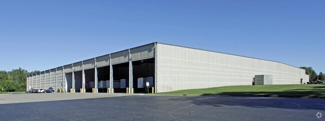
56400 Mound Rd
23-07-04-100-013
L 78C4A V T3N R12E SEC 4 COMM AT NW COR SEC 4, TH S 1270.64 FT ALG W SEC LINE TO PT OF BEG, TH S 1604.86 FT TO W 1/4 POST SEC
Lightindustrial
Macomb
X
Michigan
26099C0208H
37.18 AC
2025
W of Van Dyke/Macomb
2025
Detroit
225200
Detroit-Warren-Dearborn, MI
234,542 SF
DEMOGRAPHICS near 56400 Mound Rd
1 Mile
3 Mile
5 Mile
2024 Total Population
8,955
52,631
122,566
2029 Population
8,881
52,159
121,604
Pop Growth 2024-2029
(0.83%)
(0.90%)
(0.78%)
Average Age
43
43
42
2024 Total Households
3,858
20,290
47,128
HH Growth 2024-2029
(0.52%)
(0.87%)
(0.80%)
Median Household Inc
$88,442
$97,274
$98,248
Avg Household Size
2.30
2.60
2.60
2024 Avg HH Vehicles
2.00
2.00
2.00
Median Home Value
$402,228
$376,858
$356,885
Median Year Built
2000
1992
1991
Nearby Places
Map Layers
Map Styles
 Street
 Aerial
- Restaurants
- Banks
- Shops
- Fitness
- Groceries
Nearby Properties
Address
Land Use
TOTAL SIZE
Lot Size
Zoning
Address
Land Use
TOTAL SIZE
Lot Size
Zoning
998,316 SF
85.99 AC
CK MAP
Address
Land Use
TOTAL SIZE
Lot Size
Zoning
332,286 SF
CK MAP
Address
Land Use
TOTAL SIZE
Lot Size
Zoning
371,520 SF
21.91 AC
CK MAP
Address
Land Use
TOTAL SIZE
Lot Size
Zoning
13.61 AC
C-2
Address
Land Use
TOTAL SIZE
Lot Size
Zoning
257,878 SF
30 AC
Address
Land Use
TOTAL SIZE
Lot Size
Zoning
190,996 SF
33.80 AC
LM
Address
Land Use
TOTAL SIZE
Lot Size
Zoning
29,394 SF
33.83 AC
CK MAP
Address
Land Use
TOTAL SIZE
Lot Size
Zoning
181,725 SF
CK MAP
Address
Land Use
TOTAL SIZE
Lot Size
Zoning
167,747 SF
CK MAP
Address
Land Use
TOTAL SIZE
Lot Size
Zoning
10.28 AC
CK MAP
Address
Land Use
TOTAL SIZE
Lot Size
Zoning
9.47 AC
R-9
Address
Land Use
TOTAL SIZE
Lot Size
Zoning
217,654 SF
26.88 AC
CONSENT-GC
Address
Land Use
TOTAL SIZE
Lot Size
Zoning
117,856 SF
13.51 AC
C-3
Address
Land Use
TOTAL SIZE
Lot Size
Zoning
8.81 AC
C-6
Address
Land Use
TOTAL SIZE
Lot Size
Zoning
128,299 SF
6.92 AC
V1
Address
Land Use
TOTAL SIZE
Lot Size
Zoning
118,844 SF
17.80 AC
C-2
Address
Land Use
TOTAL SIZE
Lot Size
Zoning
134,400 SF
7.55 AC
CK MAP
Address
Land Use
TOTAL SIZE
Lot Size
Zoning
960 SF
18.63 AC
R-8
Address
Land Use
TOTAL SIZE
Lot Size
Zoning
188,047 SF
24.76 AC
RM2
Address
Land Use
TOTAL SIZE
Lot Size
Zoning
125,426 SF
11.87 AC
R-1-B
Address
Land Use
TOTAL SIZE
Lot Size
Zoning
96,460 SF
17.50 AC
Address
Land Use
TOTAL SIZE
Lot Size
Zoning
122,540 SF
CK MAP
Address
Land Use
TOTAL SIZE
Lot Size
Zoning
90,519 SF
4.12 AC
V1
Address
Land Use
TOTAL SIZE
Lot Size
Zoning
152,601 SF
13.90 AC
RM2
Address
Land Use
TOTAL SIZE
Lot Size
Zoning
95,977 SF
4.24 AC
V1
Address
Land Use
TOTAL SIZE
Lot Size
Zoning
61,573 SF
6.96 AC
C-3
Address
Land Use
TOTAL SIZE
Lot Size
Zoning
9.84 AC
R-9
Address
Land Use
TOTAL SIZE
Lot Size
Zoning
29.03 AC
CK MAP
Address
Land Use
TOTAL SIZE
Lot Size
Zoning
194,122 SF
19.28 AC
V1
The World's #1 Commercial Real Estate Marketplace
Connect with us
© 2026 CoStar Group
The information above has been obtained from sources believed reliable. While we do not doubt its accuracy we have not verified it and make no guarantee, warranty or representation about it. It is your responsibility to independently confirm its accuracy and completeness. Any projections, opinions, assumptions, or estimates used are for example only and do not represent the current or future performance of the property. The value of this transaction to you depends on tax and other factors which should be evaluated by your tax, financial, and legal advisors. You and your advisors should conduct a careful, independent investigation of the property to determine to your satisfaction the suitability of the property for your needs.