Property Record
5641 Washington St, Denver, CO 80216
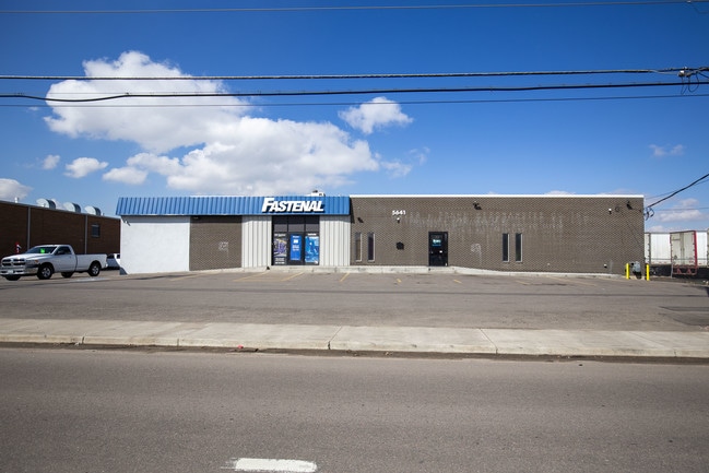

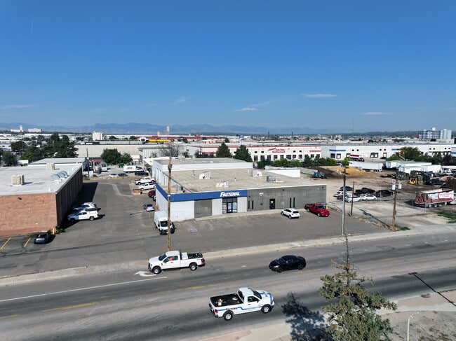

This Property Is For Sale
Current Lease Availabilities
Property Detail
5641 Washington St
1825-10-4-07-021
SUB:MAPLETON ADD DESC: S2 OF BLK 36 EXC S 145 FT OF E 220 FT
Industrialgeneral
ADAMS
I1
Colorado
B and X Area of moderate flood hazard, usually the area between the limits of the 100-year and 500-year floods.
1.44 AC
2024
Commerce City
2025
Denver
015000
Denver-Aurora-Centennial, CO
20,285 SF
NEARBY LISTINGS FOR SALE OR LEASE
DEMOGRAPHICS near 5641 Washington St
1 mile
3 mile
5 mile
2025 Total Population
3,381
96,055
404,479
2030 Population
3,837
100,357
416,660
Pop Growth 2025-2030
+ 13.49%
+ 4.48%
+ 3.01%
Average Age
38
36
37
2025 Total Households
1,138
37,665
179,633
HH Growth 2025-2030
+ 14.67%
+ 4.61%
+ 3.13%
Median Household Inc
$16,442
$97,632
$93,170
Avg Household Size
2.70
2.40
2.10
2025 Avg HH Vehicles
1.00
2.00
2.00
Median Home Value
$449,444
$566,049
$576,627
Median Year Built
2010
1975
1972
Nearby Places
Map Layers
Map Styles
 Street
 Aerial
Transit
 Traffic
 Biking
Places
Listings with unknown addresses are not visible on the map
- Restaurants
- Banks
- Shops
- Fitness
- Groceries
PUBLIC TRANSPORTATION
COMMUTER RAIL
Drive
Walk
Distance
6 min
1.9 mi
Drive
Walk
Distance
6 min
2.3 mi
AIRPORT
Denver International
Drive
Walk
Distance
Denver International
32 min
23.0 mi
Nearby Properties
Address
Land Use
TOTAL SIZE
Lot Size
Zoning
Address
Land Use
TOTAL SIZE
Lot Size
Zoning
396,741 SF
8.12 AC
A1
Address
Land Use
TOTAL SIZE
Lot Size
Zoning
552,279 SF
2.22 AC
C-RX
Address
Land Use
TOTAL SIZE
Lot Size
Zoning
657,947 SF
5.02 AC
C-RX
Address
Land Use
TOTAL SIZE
Lot Size
Zoning
6,252 SF
1.05 AC
C-MX
Address
Land Use
TOTAL SIZE
Lot Size
Zoning
294,950 SF
6.91 AC
C-RX-12
Address
Land Use
TOTAL SIZE
Lot Size
Zoning
411,031 SF
1.66 AC
I-MX
Address
Land Use
TOTAL SIZE
Lot Size
Zoning
352,600 SF
18.21 AC
I-B
Address
Land Use
TOTAL SIZE
Lot Size
Zoning
1.64 AC
CMP
Address
Land Use
TOTAL SIZE
Lot Size
Zoning
860,132 SF
68.50 AC
R-5
Address
Land Use
TOTAL SIZE
Lot Size
Zoning
84,252 SF
0.37 AC
I-MX-8
Address
Land Use
TOTAL SIZE
Lot Size
Zoning
256,155 SF
3.84 AC
Address
Land Use
TOTAL SIZE
Lot Size
Zoning
237,753 SF
18.94 AC
U-SU-B1
Address
Land Use
TOTAL SIZE
Lot Size
Zoning
3,188 SF
81.17 AC
I-B
Address
Land Use
TOTAL SIZE
Lot Size
Zoning
140,328 SF
6.54 AC
PUD
Address
Land Use
TOTAL SIZE
Lot Size
Zoning
281,209 SF
1.66 AC
C-MX-12
Address
Land Use
TOTAL SIZE
Lot Size
Zoning
8.83 AC
I-B
Address
Land Use
TOTAL SIZE
Lot Size
Zoning
649,540 SF
33.65 AC
Address
Land Use
TOTAL SIZE
Lot Size
Zoning
25,000 SF
40.42 AC
I-A
Address
Land Use
TOTAL SIZE
Lot Size
Zoning
446,845 SF
10.43 AC
CMP-NWC-G
Address
Land Use
TOTAL SIZE
Lot Size
Zoning
238,888 SF
1.13 AC
C-MX-12
Address
Land Use
TOTAL SIZE
Lot Size
Zoning
230,309 SF
0.79 AC
I-MX-8
Address
Land Use
TOTAL SIZE
Lot Size
Zoning
98,659 SF
0.48 AC
C-MX
Address
Land Use
TOTAL SIZE
Lot Size
Zoning
551,915 SF
25.76 AC
Address
Land Use
TOTAL SIZE
Lot Size
Zoning
201,798 SF
0.71 AC
I-MX-5
Address
Land Use
TOTAL SIZE
Lot Size
Zoning
470,539 SF
23.59 AC
Address
Land Use
TOTAL SIZE
Lot Size
Zoning
595,017 SF
11.62 AC
I-B
Address
Land Use
TOTAL SIZE
Lot Size
Zoning
344,689 SF
11.77 AC
I-B
Address
Land Use
TOTAL SIZE
Lot Size
Zoning
110,878 SF
4.65 AC
Address
Land Use
TOTAL SIZE
Lot Size
Zoning
727,307 SF
38.44 AC
I-B
Address
Land Use
TOTAL SIZE
Lot Size
Zoning
6,626 SF
0.11 AC
C-RX
The World's #1 Commercial Real Estate Marketplace
Connect with us
© 2026 CoStar Group
The information above has been obtained from sources believed reliable. While we do not doubt its accuracy we have not verified it and make no guarantee, warranty or representation about it. It is your responsibility to independently confirm its accuracy and completeness. Any projections, opinions, assumptions, or estimates used are for example only and do not represent the current or future performance of the property. The value of this transaction to you depends on tax and other factors which should be evaluated by your tax, financial, and legal advisors. You and your advisors should conduct a careful, independent investigation of the property to determine to your satisfaction the suitability of the property for your needs.