Property Record
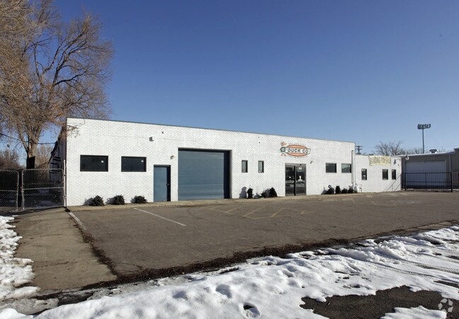
5655 Gray St, Arvada, CO 80002


Property Detail
5655 Gray St
Denver-Aurora-Centennial, CO
SECTION 12 TOWNSHIP 03 RANGE 69 QTR SE SUBDIVISIONCD 459600 SUBDIVISIONNAME LANDSDALE GARDENS PT OF PLOT 6 BLOCK LOT 000A SIZE: 40031 TRACT VALUE: .919
39-124-04-002
JEFFERSON
Industrialgeneral
Colorado
B and X Area of moderate flood hazard, usually the area between the limits of the 100-year and 500-year floods.
a
2023
0.92 AC
2024
Northwest Denver
010406
Denver
14,162 SF
NEARBY LISTINGS FOR SALE OR LEASE
DEMOGRAPHICS near 5655 Gray St
1 mile
3 mile
5 mile
2025 Total Population
10,839
134,474
382,187
2030 Population
10,854
135,809
389,398
Pop Growth 2025-2030
+ 0.14%
+ 0.99%
+ 1.89%
Average Age
39
40
39
2025 Total Households
4,488
56,732
165,621
HH Growth 2025-2030
(0.02%)
+ 0.95%
+ 1.96%
Median Household Inc
$77,775
$93,423
$95,339
Avg Household Size
2.30
2.30
2.20
2025 Avg HH Vehicles
2.00
2.00
2.00
Median Home Value
$533,638
$653,593
$637,621
Median Year Built
1972
1968
1975
Nearby Places
Map Layers
Map Styles
 Street
 Aerial
Transit
 Traffic
 Biking
Places
Listings with unknown addresses are not visible on the map
- Restaurants
- Banks
- Shops
- Fitness
- Groceries
PUBLIC TRANSPORTATION
COMMUTER RAIL
Drive
Walk
Distance
4 min
1.3 mi
Drive
Walk
Distance
5 min
1.5 mi
AIRPORT
Denver International
Drive
Walk
Distance
Denver International
36 min
27.6 mi
SALE & LEASE HISTORY
LISTING DATE
SALE/LEASE

Mar 21, 2017
For Sale
Mar 19, 2018
For Lease
Nearby Properties
Address
Land Use
TOTAL SIZE
Lot Size
Zoning
Address
Land Use
TOTAL SIZE
Lot Size
Zoning
310,267 SF
1.69 AC
C-MX
Address
Land Use
TOTAL SIZE
Lot Size
Zoning
860,132 SF
68.50 AC
R-5
Address
Land Use
TOTAL SIZE
Lot Size
Zoning
104,837 SF
0.72 AC
U-MS
Address
Land Use
TOTAL SIZE
Lot Size
Zoning
138,770 SF
4.64 AC
Address
Land Use
TOTAL SIZE
Lot Size
Zoning
30,316 SF
0.85 AC
U-MS
Address
Land Use
TOTAL SIZE
Lot Size
Zoning
113,385 SF
6.77 AC
Address
Land Use
TOTAL SIZE
Lot Size
Zoning
398,180 SF
33.31 AC
R1C
Address
Land Use
TOTAL SIZE
Lot Size
Zoning
50,372 SF
0.30 AC
U-MS
Address
Land Use
TOTAL SIZE
Lot Size
Zoning
102,182 SF
3.70 AC
CMP
Address
Land Use
TOTAL SIZE
Lot Size
Zoning
470,539 SF
23.59 AC
Address
Land Use
TOTAL SIZE
Lot Size
Zoning
105,600 SF
1.31 AC
Address
Land Use
TOTAL SIZE
Lot Size
Zoning
390,764 SF
20.19 AC
Address
Land Use
TOTAL SIZE
Lot Size
Zoning
65,336 SF
2.86 AC
Address
Land Use
TOTAL SIZE
Lot Size
Zoning
298,150 SF
24.21 AC
Address
Land Use
TOTAL SIZE
Lot Size
Zoning
283,572 SF
17.76 AC
Address
Land Use
TOTAL SIZE
Lot Size
Zoning
69,537 SF
4.49 AC
Address
Land Use
TOTAL SIZE
Lot Size
Zoning
6,731 SF
80.77 AC
Address
Land Use
TOTAL SIZE
Lot Size
Zoning
27,921 SF
0.29 AC
C-MX-5
Address
Land Use
TOTAL SIZE
Lot Size
Zoning
62,025 SF
2.49 AC
R4
Address
Land Use
TOTAL SIZE
Lot Size
Zoning
157,724 SF
10.07 AC
Address
Land Use
TOTAL SIZE
Lot Size
Zoning
436,238 SF
13.94 AC
Address
Land Use
TOTAL SIZE
Lot Size
Zoning
30,934 SF
0.31 AC
U-MS
Address
Land Use
TOTAL SIZE
Lot Size
Zoning
142,635 SF
6.84 AC
U-SU-B1
Address
Land Use
TOTAL SIZE
Lot Size
Zoning
389,561 SF
10.73 AC
Address
Land Use
TOTAL SIZE
Lot Size
Zoning
262,699 SF
13.10 AC
A2
Address
Land Use
TOTAL SIZE
Lot Size
Zoning
76,078 SF
6.64 AC
U-SU-C
Address
Land Use
TOTAL SIZE
Lot Size
Zoning
87,567 SF
14.98 AC
R-5
Address
Land Use
TOTAL SIZE
Lot Size
Zoning
115,719 SF
5.93 AC
Address
Land Use
TOTAL SIZE
Lot Size
Zoning
28,924 SF
0.14 AC
U-MS
Address
Land Use
TOTAL SIZE
Lot Size
Zoning
149,115 SF
18 AC
The World's #1 Commercial Real Estate Marketplace
Connect with us
© 2026 CoStar Group
The information above has been obtained from sources believed reliable. While we do not doubt its accuracy we have not verified it and make no guarantee, warranty or representation about it. It is your responsibility to independently confirm its accuracy and completeness. Any projections, opinions, assumptions, or estimates used are for example only and do not represent the current or future performance of the property. The value of this transaction to you depends on tax and other factors which should be evaluated by your tax, financial, and legal advisors. You and your advisors should conduct a careful, independent investigation of the property to determine to your satisfaction the suitability of the property for your needs.