Property Record
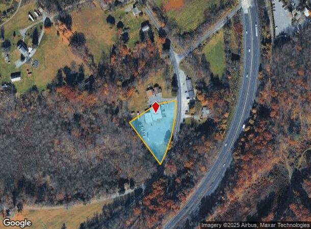
569 Route 115, Saylorsburg, PA 18353

NEARBY LISTINGS FOR SALE OR LEASE
-
-
View all Saylorsburg listings for sale on LoopNet.com
Property Detail
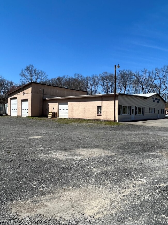
569 Route 115
East Stroudsburg, PA
Trailer Sales & Service
07.11.1.59
LOTS 1A,2
Vehiclerentalsvehiclesales
Monroe
X
Pennsylvania
42095C0020E
1a,2
2025
1.42 AC
2025
Monroe County
301202
Philadelphia
6,024 SF
DEMOGRAPHICS near 569 Route 115
1 Mile
3 Mile
5 Mile
2024 Total Population
516
8,882
24,129
2029 Population
519
8,904
24,224
Pop Growth 2024-2029
+ 0.58%
+ 0.25%
+ 0.39%
Average Age
47
44
44
2024 Total Households
214
3,691
9,565
HH Growth 2024-2029
+ 0.47%
+ 0.30%
+ 0.48%
Median Household Inc
$79,953
$73,831
$77,134
Avg Household Size
2.40
2.40
2.50
2024 Avg HH Vehicles
2.00
2.00
2.00
Median Home Value
$236,153
$236,297
$245,209
Median Year Built
1978
1971
1973
Nearby Places
Map Layers
Map Styles
 Street
 Aerial
- Restaurants
- Banks
- Shops
- Fitness
- Groceries
PUBLIC TRANSPORTATION
AIRPORT
Lehigh Valley International
DRIVE
WALK
Distance
Lehigh Valley International
36 min
25.9 mi
SALE & LEASE HISTORY
LISTING DATE
SALE/LEASE

Nov 01, 2023
For Sale
Apr 28, 2022
For Sale
Nearby Properties
Address
Land Use
TOTAL SIZE
Lot Size
Zoning
Address
Land Use
TOTAL SIZE
Lot Size
Zoning
7,204 SF
17.50 AC
R-1
Address
Land Use
TOTAL SIZE
Lot Size
Zoning
13,872 SF
23.48 AC
IE
Address
Land Use
TOTAL SIZE
Lot Size
Zoning
42,140 SF
33.11 AC
R10
Address
Land Use
TOTAL SIZE
Lot Size
Zoning
12,355 SF
2,230.15 AC
E
Address
Land Use
TOTAL SIZE
Lot Size
Zoning
7,644 SF
2.58 AC
VC
Address
Land Use
TOTAL SIZE
Lot Size
Zoning
7,704 SF
1.78 AC
R78
Address
Land Use
TOTAL SIZE
Lot Size
Zoning
34,781 SF
167.39 AC
FF
Address
Land Use
TOTAL SIZE
Lot Size
Zoning
4,699 SF
2.11 AC
VC
Address
Land Use
TOTAL SIZE
Lot Size
Zoning
1,964 SF
9.16 AC
RR
Address
Land Use
TOTAL SIZE
Lot Size
Zoning
27,383 SF
32.05 AC
RR
Address
Land Use
TOTAL SIZE
Lot Size
Zoning
7,912 SF
1.29 AC
C-1
Address
Land Use
TOTAL SIZE
Lot Size
Zoning
5,920 SF
1.70 AC
R-2
Address
Land Use
TOTAL SIZE
Lot Size
Zoning
50,000 SF
5.17 AC
1C
Address
Land Use
TOTAL SIZE
Lot Size
Zoning
92,438 SF
19.14 AC
FF
Address
Land Use
TOTAL SIZE
Lot Size
Zoning
95,160 SF
14.33 AC
IC
Address
Land Use
TOTAL SIZE
Lot Size
Zoning
2,980 SF
1.14 AC
VC
Address
Land Use
TOTAL SIZE
Lot Size
Zoning
674.77 AC
E
Address
Land Use
TOTAL SIZE
Lot Size
Zoning
346.73 AC
RC
Address
Land Use
TOTAL SIZE
Lot Size
Zoning
5,024 SF
5.31 AC
GC
Address
Land Use
TOTAL SIZE
Lot Size
Zoning
85.13 AC
C-1
Address
Land Use
TOTAL SIZE
Lot Size
Zoning
17,500 SF
2.90 AC
IL
Address
Land Use
TOTAL SIZE
Lot Size
Zoning
4,617 SF
34.94 AC
C-1
Address
Land Use
TOTAL SIZE
Lot Size
Zoning
9,600 SF
3.33 AC
C
Address
Land Use
TOTAL SIZE
Lot Size
Zoning
11.50 AC
C
Address
Land Use
TOTAL SIZE
Lot Size
Zoning
4,000 SF
3.02 AC
C-1
Address
Land Use
TOTAL SIZE
Lot Size
Zoning
28,688 SF
79.34 AC
GI
Address
Land Use
TOTAL SIZE
Lot Size
Zoning
18,424 SF
5.30 AC
IC
Address
Land Use
TOTAL SIZE
Lot Size
Zoning
118,318 SF
1.58 AC
IL
Address
Land Use
TOTAL SIZE
Lot Size
Zoning
4,475 SF
33.36 AC
C-1
Address
Land Use
TOTAL SIZE
Lot Size
Zoning
2,400 SF
3.53 AC
C
The World's #1 Commercial Real Estate Marketplace
Connect with us
© 2025 CoStar Group
The information above has been obtained from sources believed reliable. While we do not doubt its accuracy we have not verified it and make no guarantee, warranty or representation about it. It is your responsibility to independently confirm its accuracy and completeness. Any projections, opinions, assumptions, or estimates used are for example only and do not represent the current or future performance of the property. The value of this transaction to you depends on tax and other factors which should be evaluated by your tax, financial, and legal advisors. You and your advisors should conduct a careful, independent investigation of the property to determine to your satisfaction the suitability of the property for your needs.