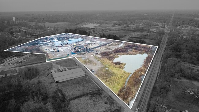
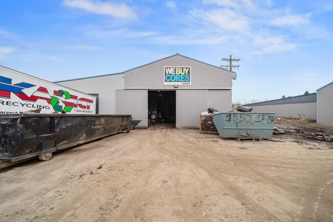
Property Record
5700 W 58Th St, Ashtabula, OH 44004

Property Detail
5700 W 58Th St
04-025-00-078-03
16
Commercialnec
Ashtabula
B and X Area of moderate flood hazard, usually the area between the limits of the 100-year and 500-year floods.
Ohio
2024
10.15 AC
2024
Ashtabula County
000703
Cleveland
20,896 SF
Cleveland-Elyria, OH
NEARBY LISTINGS FOR SALE OR LEASE
DEMOGRAPHICS near 5700 W 58Th St
1 mile
3 mile
5 mile
2025 Total Population
6,737
24,640
31,206
2030 Population
6,719
24,558
31,184
Pop Growth 2025-2030
(0.27%)
(0.33%)
(0.07%)
Average Age
39
41
42
2025 Total Households
2,677
10,441
13,352
HH Growth 2025-2030
(0.34%)
(0.46%)
(0.14%)
Median Household Inc
$42,461
$52,507
$54,542
Avg Household Size
2.30
2.20
2.20
2025 Avg HH Vehicles
2.00
2.00
2.00
Median Home Value
$81,674
$125,384
$139,760
Median Year Built
1955
1955
1956
Nearby Places
Map Layers
Map Styles
 Street
 Aerial
Layers
 Traffic
 Biking
Places
Listings with unknown addresses are not visible on the map
- Restaurants
- Banks
- Shops
- Fitness
- Groceries
SALE & LEASE HISTORY
LISTING DATE
SALE/LEASE

Feb 02, 2024
For Sale
Nearby Properties
Address
Land Use
TOTAL SIZE
Lot Size
Zoning
Address
Land Use
TOTAL SIZE
Lot Size
Zoning
311,348 SF
128.96 AC
Address
Land Use
TOTAL SIZE
Lot Size
Zoning
224,856 SF
79.47 AC
Address
Land Use
TOTAL SIZE
Lot Size
Zoning
297,379 SF
2.03 AC
Address
Land Use
TOTAL SIZE
Lot Size
Zoning
98,137 SF
40.63 AC
Address
Land Use
TOTAL SIZE
Lot Size
Zoning
936,616 SF
32.04 AC
Address
Land Use
TOTAL SIZE
Lot Size
Zoning
231,332 SF
16.53 AC
Address
Land Use
TOTAL SIZE
Lot Size
Zoning
148,372 SF
18 AC
Address
Land Use
TOTAL SIZE
Lot Size
Zoning
Address
Land Use
TOTAL SIZE
Lot Size
Zoning
192,830 SF
9.09 AC
Address
Land Use
TOTAL SIZE
Lot Size
Zoning
7,882 SF
13.53 AC
Address
Land Use
TOTAL SIZE
Lot Size
Zoning
59,222 SF
6.76 AC
Address
Land Use
TOTAL SIZE
Lot Size
Zoning
252,612 SF
20.47 AC
Address
Land Use
TOTAL SIZE
Lot Size
Zoning
21,912 SF
1.47 AC
Address
Land Use
TOTAL SIZE
Lot Size
Zoning
30,530 SF
2.72 AC
Address
Land Use
TOTAL SIZE
Lot Size
Zoning
25,607 SF
1.56 AC
Address
Land Use
TOTAL SIZE
Lot Size
Zoning
2.13 AC
Address
Land Use
TOTAL SIZE
Lot Size
Zoning
78,016 SF
7.70 AC
Address
Land Use
TOTAL SIZE
Lot Size
Zoning
30,642 SF
0.12 AC
Address
Land Use
TOTAL SIZE
Lot Size
Zoning
119,090 SF
8.49 AC
Address
Land Use
TOTAL SIZE
Lot Size
Zoning
116,093 SF
28.16 AC
Address
Land Use
TOTAL SIZE
Lot Size
Zoning
26,026 SF
2.08 AC
Address
Land Use
TOTAL SIZE
Lot Size
Zoning
60,687 SF
3.91 AC
Address
Land Use
TOTAL SIZE
Lot Size
Zoning
40,222 SF
3.03 AC
Address
Land Use
TOTAL SIZE
Lot Size
Zoning
50,596 SF
42.10 AC
Address
Land Use
TOTAL SIZE
Lot Size
Zoning
22,832 SF
9.89 AC
Address
Land Use
TOTAL SIZE
Lot Size
Zoning
59,936 SF
0.31 AC
Address
Land Use
TOTAL SIZE
Lot Size
Zoning
31,454 SF
0.84 AC
Address
Land Use
TOTAL SIZE
Lot Size
Zoning
206,345 SF
27.28 AC
Address
Land Use
TOTAL SIZE
Lot Size
Zoning
292,721 SF
19.05 AC
Address
Land Use
TOTAL SIZE
Lot Size
Zoning
34,196 SF
2.40 AC
The World's #1 Commercial Real Estate Marketplace
Connect with us
© 2026 CoStar Group
The information above has been obtained from sources believed reliable. While we do not doubt its accuracy we have not verified it and make no guarantee, warranty or representation about it. It is your responsibility to independently confirm its accuracy and completeness. Any projections, opinions, assumptions, or estimates used are for example only and do not represent the current or future performance of the property. The value of this transaction to you depends on tax and other factors which should be evaluated by your tax, financial, and legal advisors. You and your advisors should conduct a careful, independent investigation of the property to determine to your satisfaction the suitability of the property for your needs.