Property Record
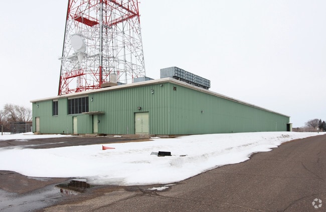
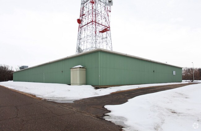
5725 287Th St, Stacy, MN 55079

Property Detail
5725 287Th St
21-10127-00
PT SE1/4 OF NW1/4 DES AS FOL: BG AT A ONE INCH PIPE ON N BOUNDARY OF SE1/4 OF NW1/4 WHICH IRON PIPE LIES N 88D 28' W 305.00
Commercialnec
Chisago
A
Minnesota
B and X Area of moderate flood hazard, usually the area between the limits of the 100-year and 500-year floods.
2.67 AC
2026
Chisago County
2024
Minneapolis/St Paul
110404
Minneapolis-St. Paul-Bloomington, MN-WI
25,952 SF
NEARBY LISTINGS FOR SALE OR LEASE
-
-
View all Stacy listings for sale on LoopNet.com
DEMOGRAPHICS near 5725 287Th St
1 mile
3 mile
5 mile
2025 Total Population
193
7,452
17,782
2030 Population
198
7,621
18,244
Pop Growth 2025-2030
+ 2.59%
+ 2.27%
+ 2.60%
Average Age
38
40
41
2025 Total Households
63
2,762
6,621
HH Growth 2025-2030
+ 3.17%
+ 2.39%
+ 2.70%
Median Household Inc
$111,363
$86,723
$102,451
Avg Household Size
3.00
2.70
2.60
2025 Avg HH Vehicles
3.00
2.00
2.00
Median Home Value
$379,411
$316,122
$360,637
Median Year Built
1995
1991
1991
Nearby Places
Map Layers
Map Styles
 Street
 Aerial
Layers
 Traffic
 Biking
Places
Listings with unknown addresses are not visible on the map
- Restaurants
- Banks
- Shops
- Fitness
- Groceries
PUBLIC TRANSPORTATION
AIRPORT
Minneapolis-St Paul International/Wold-Chamberlain
Drive
Walk
Distance
Minneapolis-St Paul International/Wold-Chamberlain
60 min
40.8 mi
Nearby Properties
Address
Land Use
TOTAL SIZE
Lot Size
Zoning
Address
Land Use
TOTAL SIZE
Lot Size
Zoning
157,726 SF
51.35 AC
I
Address
Land Use
TOTAL SIZE
Lot Size
Zoning
87,648 SF
10.70 AC
Address
Land Use
TOTAL SIZE
Lot Size
Zoning
66,000 SF
7.90 AC
I
Address
Land Use
TOTAL SIZE
Lot Size
Zoning
3,328 SF
50.50 AC
RM
Address
Land Use
TOTAL SIZE
Lot Size
Zoning
94,206 SF
8.23 AC
I
Address
Land Use
TOTAL SIZE
Lot Size
Zoning
111,613 SF
32.60 AC
I
Address
Land Use
TOTAL SIZE
Lot Size
Zoning
35,076 SF
6.40 AC
I
Address
Land Use
TOTAL SIZE
Lot Size
Zoning
59,381 SF
8.62 AC
I
Address
Land Use
TOTAL SIZE
Lot Size
Zoning
79,620 SF
2.41 AC
I
Address
Land Use
TOTAL SIZE
Lot Size
Zoning
45,160 SF
5.90 AC
C
Address
Land Use
TOTAL SIZE
Lot Size
Zoning
52,000 SF
8.33 AC
I
Address
Land Use
TOTAL SIZE
Lot Size
Zoning
269.50 AC
I
Address
Land Use
TOTAL SIZE
Lot Size
Zoning
51,808 SF
6.51 AC
LI
Address
Land Use
TOTAL SIZE
Lot Size
Zoning
32,708 SF
3.30 AC
R6
Address
Land Use
TOTAL SIZE
Lot Size
Zoning
54,000 SF
4.95 AC
I
Address
Land Use
TOTAL SIZE
Lot Size
Zoning
29,076 SF
3.67 AC
R6
Address
Land Use
TOTAL SIZE
Lot Size
Zoning
39,968 SF
7 AC
I
Address
Land Use
TOTAL SIZE
Lot Size
Zoning
32,960 SF
2.50 AC
R6
Address
Land Use
TOTAL SIZE
Lot Size
Zoning
29,190 SF
7.60 AC
GB
Address
Land Use
TOTAL SIZE
Lot Size
Zoning
44,850 SF
15.37 AC
C
Address
Land Use
TOTAL SIZE
Lot Size
Zoning
20,000 SF
15.60 AC
I
Address
Land Use
TOTAL SIZE
Lot Size
Zoning
2,412 SF
30 AC
R5
Address
Land Use
TOTAL SIZE
Lot Size
Zoning
7,259 SF
3.50 AC
GB
Address
Land Use
TOTAL SIZE
Lot Size
Zoning
39,600 SF
12.30 AC
GB
Address
Land Use
TOTAL SIZE
Lot Size
Zoning
63,360 SF
4.80 AC
I
Address
Land Use
TOTAL SIZE
Lot Size
Zoning
26,280 SF
2.10 AC
LI
Address
Land Use
TOTAL SIZE
Lot Size
Zoning
30,000 SF
3.43 AC
I
Address
Land Use
TOTAL SIZE
Lot Size
Zoning
6,543 SF
0.43 AC
C
Address
Land Use
TOTAL SIZE
Lot Size
Zoning
21,182 SF
1.34 AC
C
The World's #1 Commercial Real Estate Marketplace
Connect with us
© 2026 CoStar Group
The information above has been obtained from sources believed reliable. While we do not doubt its accuracy we have not verified it and make no guarantee, warranty or representation about it. It is your responsibility to independently confirm its accuracy and completeness. Any projections, opinions, assumptions, or estimates used are for example only and do not represent the current or future performance of the property. The value of this transaction to you depends on tax and other factors which should be evaluated by your tax, financial, and legal advisors. You and your advisors should conduct a careful, independent investigation of the property to determine to your satisfaction the suitability of the property for your needs.