Property Record
5933 Stoddard Rd, Modesto, CA 95356


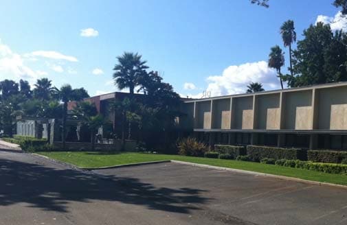
Property Detail
5933 Stoddard Rd
136-32-25
EQUIPMENT & SUPPLIES DD
Officebuilding
Stanislaus
B and X Area of moderate flood hazard, usually the area between the limits of the 100-year and 500-year floods.
California
2025
2.64 AC
2025
Modesto
000501
Stockton/Modesto
29,332 SF
Modesto, CA
NEARBY LISTINGS FOR SALE OR LEASE
DEMOGRAPHICS near 5933 Stoddard Rd
1 mile
3 mile
5 mile
2025 Total Population
2,321
31,934
95,298
2030 Population
2,311
32,278
96,443
Pop Growth 2025-2030
(0.43%)
+ 1.08%
+ 1.20%
Average Age
37
39
39
2025 Total Households
692
10,363
32,337
HH Growth 2025-2030
(0.29%)
+ 1.16%
+ 1.23%
Median Household Inc
$97,058
$106,084
$91,967
Avg Household Size
3.30
3.00
2.90
2025 Avg HH Vehicles
3.00
2.00
2.00
Median Home Value
$454,545
$530,787
$498,943
Median Year Built
1993
1989
1983
Nearby Places
Map Layers
Map Styles
 Street
 Aerial
Layers
 Traffic
 Biking
Places
Listings with unknown addresses are not visible on the map
- Restaurants
- Banks
- Shops
- Fitness
- Groceries
PUBLIC TRANSPORTATION
AIRPORT
Stockton Metro
Drive
Walk
Distance
Stockton Metro
30 min
19.7 mi
Freight Ports
Port of Stockton
Drive
Walk
Distance
Port of Stockton
39 min
28.2 mi
SALE & LEASE HISTORY
LISTING DATE
SALE/LEASE

Sep 25, 2016
For Lease
Nearby Properties
Address
Land Use
TOTAL SIZE
Lot Size
Zoning
Address
Land Use
TOTAL SIZE
Lot Size
Zoning
640,835 SF
47.18 AC
PC
Address
Land Use
TOTAL SIZE
Lot Size
Zoning
541,375 SF
37.18 AC
Address
Land Use
TOTAL SIZE
Lot Size
Zoning
706,042 SF
24.81 AC
PD109
Address
Land Use
TOTAL SIZE
Lot Size
Zoning
25,000 SF
131.14 AC
Address
Land Use
TOTAL SIZE
Lot Size
Zoning
6,160 SF
46.47 AC
Address
Land Use
TOTAL SIZE
Lot Size
Zoning
9.25 AC
MODSP
Address
Land Use
TOTAL SIZE
Lot Size
Zoning
175,804 SF
13.79 AC
Address
Land Use
TOTAL SIZE
Lot Size
Zoning
127,142 SF
3.89 AC
MODSP
Address
Land Use
TOTAL SIZE
Lot Size
Zoning
33,530 SF
3.60 AC
Address
Land Use
TOTAL SIZE
Lot Size
Zoning
164,473 SF
3.50 AC
MODSP
Address
Land Use
TOTAL SIZE
Lot Size
Zoning
155,462 SF
13.69 AC
PD
Address
Land Use
TOTAL SIZE
Lot Size
Zoning
41,260 SF
6 AC
MODSP
Address
Land Use
TOTAL SIZE
Lot Size
Zoning
45,916 SF
4.69 AC
MODPO
Address
Land Use
TOTAL SIZE
Lot Size
Zoning
139,552 SF
12.58 AC
COUPI
Address
Land Use
TOTAL SIZE
Lot Size
Zoning
85,040 SF
4.46 AC
Address
Land Use
TOTAL SIZE
Lot Size
Zoning
134,096 SF
10.74 AC
Address
Land Use
TOTAL SIZE
Lot Size
Zoning
130,630 SF
11.13 AC
PD
Address
Land Use
TOTAL SIZE
Lot Size
Zoning
157,353 SF
9 AC
Address
Land Use
TOTAL SIZE
Lot Size
Zoning
75,922 SF
3.93 AC
Address
Land Use
TOTAL SIZE
Lot Size
Zoning
139,638 SF
39.25 AC
Address
Land Use
TOTAL SIZE
Lot Size
Zoning
71,877 SF
2 AC
MODSP
Address
Land Use
TOTAL SIZE
Lot Size
Zoning
90,250 SF
7.16 AC
Address
Land Use
TOTAL SIZE
Lot Size
Zoning
1,052 SF
360.20 AC
A240
Address
Land Use
TOTAL SIZE
Lot Size
Zoning
66,340 SF
5.94 AC
Address
Land Use
TOTAL SIZE
Lot Size
Zoning
123,325 SF
9.62 AC
PDCOM
Address
Land Use
TOTAL SIZE
Lot Size
Zoning
87,000 SF
5.08 AC
COUPD
Address
Land Use
TOTAL SIZE
Lot Size
Zoning
51,677 SF
8.61 AC
Address
Land Use
TOTAL SIZE
Lot Size
Zoning
60,000 SF
2.88 AC
PD
Address
Land Use
TOTAL SIZE
Lot Size
Zoning
7.82 AC
Address
Land Use
TOTAL SIZE
Lot Size
Zoning
9,725 SF
2.36 AC
The World's #1 Commercial Real Estate Marketplace
Connect with us
© 2026 CoStar Group
The information above has been obtained from sources believed reliable. While we do not doubt its accuracy we have not verified it and make no guarantee, warranty or representation about it. It is your responsibility to independently confirm its accuracy and completeness. Any projections, opinions, assumptions, or estimates used are for example only and do not represent the current or future performance of the property. The value of this transaction to you depends on tax and other factors which should be evaluated by your tax, financial, and legal advisors. You and your advisors should conduct a careful, independent investigation of the property to determine to your satisfaction the suitability of the property for your needs.