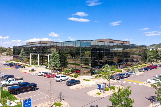
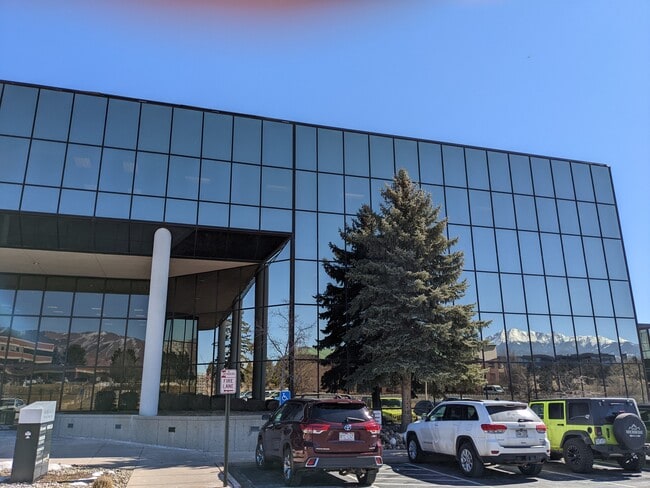
Property Record
5755 Mark Dabling Blvd, Colorado Springs, CO 80919


Current Lease Availabilities
Property Detail
5755 Mark Dabling Blvd
63184-02-019
LOT 2 BLK 1 NORTH CREEK SUBDIVISION COLO SPGS, EX THAT PT CONV TO D O T BY REC #205127350
Officebuilding
EL PASO
MX-M HS CU
Colorado
B and X Area of moderate flood hazard, usually the area between the limits of the 100-year and 500-year floods.
2
2024
5.30 AC
2025
Northwest
003705
Colorado Springs
109,421 SF
Colorado Springs, CO
NEARBY LISTINGS FOR SALE OR LEASE
DEMOGRAPHICS near 5755 Mark Dabling Blvd
1 mile
3 mile
5 mile
2025 Total Population
7,118
74,867
195,778
2030 Population
7,188
75,747
197,680
Pop Growth 2025-2030
+ 0.98%
+ 1.18%
+ 0.97%
Average Age
38
41
40
2025 Total Households
3,040
31,763
80,945
HH Growth 2025-2030
+ 1.18%
+ 1.45%
+ 1.25%
Median Household Inc
$86,921
$85,815
$87,972
Avg Household Size
2.30
2.30
2.30
2025 Avg HH Vehicles
2.00
2.00
2.00
Median Home Value
$519,861
$472,235
$469,289
Median Year Built
1986
1984
1982
Nearby Places
Map Layers
Map Styles
 Street
 Aerial
Layers
 Traffic
 Biking
Places
Listings with unknown addresses are not visible on the map
- Restaurants
- Banks
- Shops
- Fitness
- Groceries
PUBLIC TRANSPORTATION
AIRPORT
City of Colorado Springs Municipal
Drive
Walk
Distance
City of Colorado Springs Municipal
29 min
17.5 mi
Nearby Properties
Address
Land Use
TOTAL SIZE
Lot Size
Zoning
Address
Land Use
TOTAL SIZE
Lot Size
Zoning
662,208 SF
14.96 AC
BP
Address
Land Use
TOTAL SIZE
Lot Size
Zoning
62,201 SF
5.68 AC
MX-N
Address
Land Use
TOTAL SIZE
Lot Size
Zoning
409,164 SF
19.26 AC
PUD
Address
Land Use
TOTAL SIZE
Lot Size
Zoning
117,227 SF
12.28 AC
PDZ HS
Address
Land Use
TOTAL SIZE
Lot Size
Zoning
747,294 SF
61.26 AC
BP HS
Address
Land Use
TOTAL SIZE
Lot Size
Zoning
80,802 SF
14.45 AC
PF NNA
Address
Land Use
TOTAL SIZE
Lot Size
Zoning
80,110 SF
2.61 AC
OR CU
Address
Land Use
TOTAL SIZE
Lot Size
Zoning
77,655 SF
8.39 AC
MX-N MX-N/
Address
Land Use
TOTAL SIZE
Lot Size
Zoning
113,069 SF
44.99 AC
R-E HS
Address
Land Use
TOTAL SIZE
Lot Size
Zoning
89,592 SF
7.60 AC
R-E CU
Address
Land Use
TOTAL SIZE
Lot Size
Zoning
71,542 SF
10.11 AC
PF
Address
Land Use
TOTAL SIZE
Lot Size
Zoning
134,592 SF
10.09 AC
MX-L LI CU
Address
Land Use
TOTAL SIZE
Lot Size
Zoning
131,696 SF
9.24 AC
MX-M
Address
Land Use
TOTAL SIZE
Lot Size
Zoning
100,930 SF
7.75 AC
BP CU
Address
Land Use
TOTAL SIZE
Lot Size
Zoning
30,757 SF
6.19 AC
MX-N CU HS
Address
Land Use
TOTAL SIZE
Lot Size
Zoning
34,443 SF
5.14 AC
PF
Address
Land Use
TOTAL SIZE
Lot Size
Zoning
49,023 SF
5.68 AC
MX-L NNA
Address
Land Use
TOTAL SIZE
Lot Size
Zoning
45,141 SF
6.97 AC
R-5/CR
Address
Land Use
TOTAL SIZE
Lot Size
Zoning
83,479 SF
0.03 AC
OC HS ??
Address
Land Use
TOTAL SIZE
Lot Size
Zoning
53,632 SF
3.42 AC
PF SS
Address
Land Use
TOTAL SIZE
Lot Size
Zoning
158,502 SF
5.73 AC
MX-N HS
Address
Land Use
TOTAL SIZE
Lot Size
Zoning
41,015 SF
0.62 AC
BP
Address
Land Use
TOTAL SIZE
Lot Size
Zoning
23,431 SF
0.17 AC
R-E MX-M P
Address
Land Use
TOTAL SIZE
Lot Size
Zoning
23,324 SF
7.84 AC
MX-N CU
Address
Land Use
TOTAL SIZE
Lot Size
Zoning
301,559 SF
46.67 AC
BP/CR CU H
Address
Land Use
TOTAL SIZE
Lot Size
Zoning
61,098 SF
5.93 AC
LI
Address
Land Use
TOTAL SIZE
Lot Size
Zoning
42,365 SF
3.86 AC
MX-M CU SS
Address
Land Use
TOTAL SIZE
Lot Size
Zoning
49,277 SF
7 AC
MX-L/CR
Address
Land Use
TOTAL SIZE
Lot Size
Zoning
88.37 AC
BP/CR HS C
Address
Land Use
TOTAL SIZE
Lot Size
Zoning
249,958 SF
21.03 AC
BP/CR HS C
The World's #1 Commercial Real Estate Marketplace
Connect with us
© 2026 CoStar Group
The information above has been obtained from sources believed reliable. While we do not doubt its accuracy we have not verified it and make no guarantee, warranty or representation about it. It is your responsibility to independently confirm its accuracy and completeness. Any projections, opinions, assumptions, or estimates used are for example only and do not represent the current or future performance of the property. The value of this transaction to you depends on tax and other factors which should be evaluated by your tax, financial, and legal advisors. You and your advisors should conduct a careful, independent investigation of the property to determine to your satisfaction the suitability of the property for your needs.