Property Record
5831 Hilltop Dr, Flowery Branch, GA 30542
NEARBY LISTINGS FOR SALE OR LEASE
-
-
-
No Photo
-
-
-
-
-
View all Flowery Branch listings for sale on LoopNet.com
Property Detail
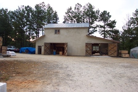
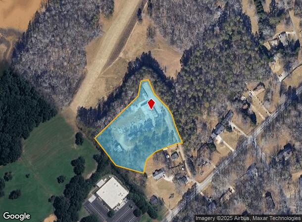
5831 Hilltop Dr
08-00133-03-006
5831 HILLTOP DRIVE
Manufacturinglight
Hall
X
Georgia
13139C0291H
133
2025
3.86 AC
2025
I-985/Gainesville
001606
Atlanta
6,200 SF
Gainesville, GA
DEMOGRAPHICS near 5831 Hilltop Dr
1 Mile
3 Mile
5 Mile
2024 Total Population
4,764
27,351
65,654
2029 Population
5,353
30,608
72,987
Pop Growth 2024-2029
+ 12.36%
+ 11.91%
+ 11.17%
Average Age
40
40
39
2024 Total Households
1,723
9,891
22,823
HH Growth 2024-2029
+ 12.36%
+ 11.87%
+ 11.27%
Median Household Inc
$70,257
$79,979
$81,093
Avg Household Size
2.70
2.70
2.80
2024 Avg HH Vehicles
2.00
2.00
2.00
Median Home Value
$264,096
$298,686
$308,218
Median Year Built
1999
2001
2000
Nearby Places
- Restaurants
- Banks
- Shops
- Fitness
- Groceries
Nearby Properties
Address
Land Use
TOTAL SIZE
Lot Size
Zoning
Address
Land Use
TOTAL SIZE
Lot Size
Zoning
285,000 SF
97.06 AC
M-I
Address
Land Use
TOTAL SIZE
Lot Size
Zoning
5,760 SF
38.07 AC
R-III
Address
Land Use
TOTAL SIZE
Lot Size
Zoning
815,563 SF
58.80 AC
M-I
Address
Land Use
TOTAL SIZE
Lot Size
Zoning
102,060 SF
31.90 AC
R-1I/H-B
Address
Land Use
TOTAL SIZE
Lot Size
Zoning
101,632 SF
78.33 AC
M-I
Address
Land Use
TOTAL SIZE
Lot Size
Zoning
85,900 SF
25.29 AC
H-B
Address
Land Use
TOTAL SIZE
Lot Size
Zoning
656,200 SF
70.29 AC
M-1
Address
Land Use
TOTAL SIZE
Lot Size
Zoning
213,532 SF
44.32 AC
M-I
Address
Land Use
TOTAL SIZE
Lot Size
Zoning
224,093 SF
33.94 AC
M-I
Address
Land Use
TOTAL SIZE
Lot Size
Zoning
447,120 SF
35 AC
M-1
Address
Land Use
TOTAL SIZE
Lot Size
Zoning
143,000 SF
41.30 AC
M-I
Address
Land Use
TOTAL SIZE
Lot Size
Zoning
104,340 SF
42.22 AC
INST
Address
Land Use
TOTAL SIZE
Lot Size
Zoning
175,622 SF
20.22 AC
M-2
Address
Land Use
TOTAL SIZE
Lot Size
Zoning
458,256 SF
26.39 AC
M-I
Address
Land Use
TOTAL SIZE
Lot Size
Zoning
304,844 SF
37.58 AC
M-2
Address
Land Use
TOTAL SIZE
Lot Size
Zoning
261,368 SF
5.80 AC
M-I
Address
Land Use
TOTAL SIZE
Lot Size
Zoning
269,130 SF
25.34 AC
M-1
Address
Land Use
TOTAL SIZE
Lot Size
Zoning
300,000 SF
23.03 AC
M-II
Address
Land Use
TOTAL SIZE
Lot Size
Zoning
515,468 SF
92 AC
I-1
Address
Land Use
TOTAL SIZE
Lot Size
Zoning
213,480 SF
13.16 AC
M-1
Address
Land Use
TOTAL SIZE
Lot Size
Zoning
194,748 SF
1.09 AC
PCD
Address
Land Use
TOTAL SIZE
Lot Size
Zoning
183,700 SF
19.94 AC
M-1
Address
Land Use
TOTAL SIZE
Lot Size
Zoning
58.61 AC
INST
Address
Land Use
TOTAL SIZE
Lot Size
Zoning
145,080 SF
24.51 AC
M-2
Address
Land Use
TOTAL SIZE
Lot Size
Zoning
158,900 SF
13.94 AC
M-II
Address
Land Use
TOTAL SIZE
Lot Size
Zoning
169,345 SF
19.60 AC
M-1
Address
Land Use
TOTAL SIZE
Lot Size
Zoning
6,400 SF
0.03 AC
V-C
Address
Land Use
TOTAL SIZE
Lot Size
Zoning
208,964 SF
63.46 AC
M-2
Address
Land Use
TOTAL SIZE
Lot Size
Zoning
120,204 SF
14.77 AC
H-B
Address
Land Use
TOTAL SIZE
Lot Size
Zoning
125,400 SF
21.87 AC
MUNI
The World's #1 Commercial Real Estate Marketplace
Connect with us
© 2025 CoStar Group
The information above has been obtained from sources believed reliable. While we do not doubt its accuracy we have not verified it and make no guarantee, warranty or representation about it. It is your responsibility to independently confirm its accuracy and completeness. Any projections, opinions, assumptions, or estimates used are for example only and do not represent the current or future performance of the property. The value of this transaction to you depends on tax and other factors which should be evaluated by your tax, financial, and legal advisors. You and your advisors should conduct a careful, independent investigation of the property to determine to your satisfaction the suitability of the property for your needs.