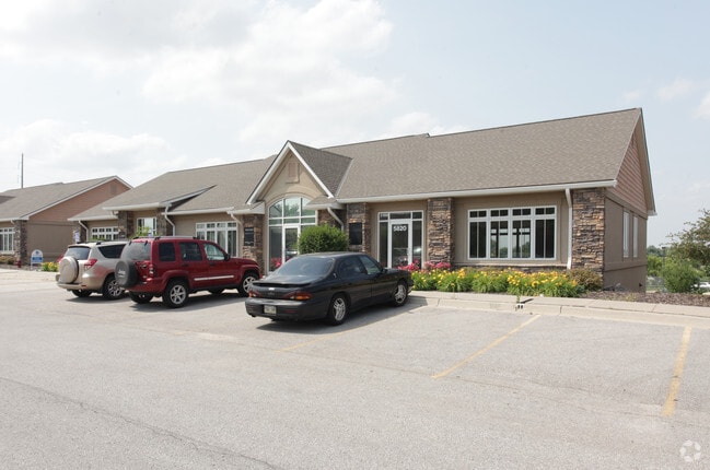
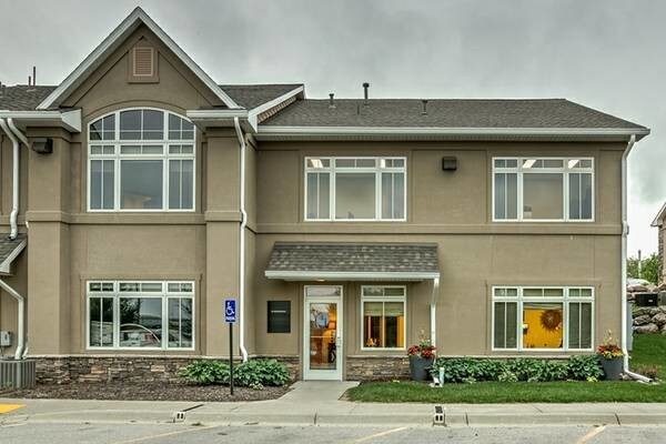
Property Record
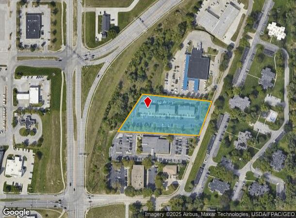
5834 S 142Nd St, Omaha, NE 68137
NEARBY LISTINGS FOR SALE OR LEASE
Property Detail
5834 S 142Nd St
Omaha-Council Bluffs, NE-IA
Pioneer Hills Office Park Condo
1301-2800-20
PIONEER HILLS OFFICE PARK CONDO LOT 1 BLOCK 0 5.5555%
Officebuilding
Douglas
X
Nebraska
31153C0035H
1
2024
0.13 AC
2025
Southwest Omaha
007463
Omaha/Council Bluffs
1,408 SF
DEMOGRAPHICS near 5834 S 142Nd St
1 Mile
3 Mile
5 Mile
2024 Total Population
13,519
82,287
197,845
2029 Population
13,743
84,325
203,898
Pop Growth 2024-2029
+ 1.66%
+ 2.48%
+ 3.06%
Average Age
38
38
39
2024 Total Households
5,390
31,617
76,505
HH Growth 2024-2029
+ 1.78%
+ 2.58%
+ 3.03%
Median Household Inc
$77,232
$88,713
$92,885
Avg Household Size
2.50
2.50
2.50
2024 Avg HH Vehicles
2.00
2.00
2.00
Median Home Value
$183,942
$234,170
$268,093
Median Year Built
1977
1986
1988
Nearby Places
Map Layers
Map Styles
 Street
 Aerial
- Restaurants
- Banks
- Shops
- Fitness
- Groceries
PUBLIC TRANSPORTATION
AIRPORT
Eppley Airfield
DRIVE
WALK
Distance
Eppley Airfield
30 min
17.8 mi
Freight Ports
Tulsa Port Of Catoosa
DRIVE
WALK
Distance
Tulsa Port Of Catoosa
475 min
424.3 mi
SALE & LEASE HISTORY
LISTING DATE
SALE/LEASE

May 23, 2019
For Sale
Jun 27, 2019
For Sale
Nearby Properties
Address
Land Use
TOTAL SIZE
Lot Size
Zoning
Address
Land Use
TOTAL SIZE
Lot Size
Zoning
3,654 SF
39.62 AC
Address
Land Use
TOTAL SIZE
Lot Size
Zoning
370,890 SF
11.20 AC
CC
Address
Land Use
TOTAL SIZE
Lot Size
Zoning
315,685 SF
21.57 AC
RG10
Address
Land Use
TOTAL SIZE
Lot Size
Zoning
56,174 SF
8.65 AC
Address
Land Use
TOTAL SIZE
Lot Size
Zoning
252,985 SF
6.53 AC
Address
Land Use
TOTAL SIZE
Lot Size
Zoning
8.10 AC
Address
Land Use
TOTAL SIZE
Lot Size
Zoning
369,614 SF
18.03 AC
CC
Address
Land Use
TOTAL SIZE
Lot Size
Zoning
23.99 AC
Address
Land Use
TOTAL SIZE
Lot Size
Zoning
294,334 SF
19.14 AC
R6
Address
Land Use
TOTAL SIZE
Lot Size
Zoning
22.05 AC
Address
Land Use
TOTAL SIZE
Lot Size
Zoning
85,632 SF
5.69 AC
Address
Land Use
TOTAL SIZE
Lot Size
Zoning
282,180 SF
13.96 AC
Address
Land Use
TOTAL SIZE
Lot Size
Zoning
23,890 SF
14.34 AC
I2
Address
Land Use
TOTAL SIZE
Lot Size
Zoning
423,905 SF
21.96 AC
GI
Address
Land Use
TOTAL SIZE
Lot Size
Zoning
281,964 SF
18.15 AC
R6
Address
Land Use
TOTAL SIZE
Lot Size
Zoning
210,585 SF
142.28 AC
I2
Address
Land Use
TOTAL SIZE
Lot Size
Zoning
274,072 SF
12.06 AC
Address
Land Use
TOTAL SIZE
Lot Size
Zoning
268,545 SF
7.53 AC
Address
Land Use
TOTAL SIZE
Lot Size
Zoning
124,820 SF
9.69 AC
MU
Address
Land Use
TOTAL SIZE
Lot Size
Zoning
120,500 SF
12.05 AC
IL
Address
Land Use
TOTAL SIZE
Lot Size
Zoning
238,428 SF
18.64 AC
R5
Address
Land Use
TOTAL SIZE
Lot Size
Zoning
154,164 SF
13.33 AC
Address
Land Use
TOTAL SIZE
Lot Size
Zoning
201,293 SF
4.71 AC
Address
Land Use
TOTAL SIZE
Lot Size
Zoning
128,497 SF
13.49 AC
Address
Land Use
TOTAL SIZE
Lot Size
Zoning
12,998 SF
15.63 AC
Address
Land Use
TOTAL SIZE
Lot Size
Zoning
20.66 AC
Address
Land Use
TOTAL SIZE
Lot Size
Zoning
8,700 SF
12.68 AC
I2
Address
Land Use
TOTAL SIZE
Lot Size
Zoning
162,717 SF
6.73 AC
R6
Address
Land Use
TOTAL SIZE
Lot Size
Zoning
106,350 SF
10.99 AC
Address
Land Use
TOTAL SIZE
Lot Size
Zoning
170,760 SF
10.30 AC
RG10
The World's #1 Commercial Real Estate Marketplace
Connect with us
© 2025 CoStar Group
The information above has been obtained from sources believed reliable. While we do not doubt its accuracy we have not verified it and make no guarantee, warranty or representation about it. It is your responsibility to independently confirm its accuracy and completeness. Any projections, opinions, assumptions, or estimates used are for example only and do not represent the current or future performance of the property. The value of this transaction to you depends on tax and other factors which should be evaluated by your tax, financial, and legal advisors. You and your advisors should conduct a careful, independent investigation of the property to determine to your satisfaction the suitability of the property for your needs.