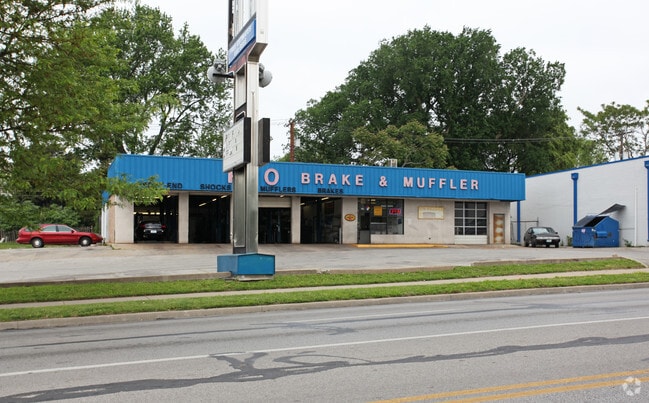
Property Record
5840 Troost Ave, Kansas City, MO 64110


Current Lease Availabilities
NEARBY LISTINGS FOR SALE OR LEASE
Property Detail
5840 Troost Ave
Kansas City, MO-KS
Rockhill Ridge
30-840-31-25-00-0-00-000
ROCKHILL RIDGE S 5 OF LOT 26 & ALL OF LOTS 27 & 28
Autorepair
Jackson
X
Missouri
29095C0264G
26
2023
0.44 AC
2025
Brookside
008200
Kansas City
4,277 SF
DEMOGRAPHICS near 5840 Troost Ave
1 Mile
3 Mile
5 Mile
2024 Total Population
16,115
118,668
248,205
2029 Population
16,100
120,111
252,845
Pop Growth 2024-2029
(0.09%)
+ 1.22%
+ 1.87%
Average Age
38
39
39
2024 Total Households
6,442
54,653
113,916
HH Growth 2024-2029
(0.29%)
+ 1.14%
+ 1.83%
Median Household Inc
$68,623
$66,377
$64,225
Avg Household Size
2.30
2.10
2.10
2024 Avg HH Vehicles
2.00
2.00
2.00
Median Home Value
$257,011
$273,935
$259,999
Median Year Built
1946
1949
1954
Nearby Places
Map Layers
Map Styles
 Street
 Aerial
- Restaurants
- Banks
- Shops
- Fitness
- Groceries
PUBLIC TRANSPORTATION
COMMUTER RAIL
Kansas City (Lincoln Service Missouri River Runner - Amtrak, Missouri River Runner - Amtrak, Southwest Chief - Amtrak)
DRIVE
WALK
Distance
Kansas City (Lincoln Service Missouri River Runner - Amtrak, Missouri River Runner - Amtrak, Southwest Chief - Amtrak)
11 min
5.3 mi
AIRPORT
Kansas City International
DRIVE
WALK
Distance
Kansas City International
38 min
26.8 mi
Freight Ports
Tulsa Port Of Catoosa
DRIVE
WALK
Distance
Tulsa Port Of Catoosa
264 min
232.8 mi
Nearby Properties
Address
Land Use
TOTAL SIZE
Lot Size
Zoning
Address
Land Use
TOTAL SIZE
Lot Size
Zoning
761,113 SF
18.37 AC
KC3
Address
Land Use
TOTAL SIZE
Lot Size
Zoning
105,247 SF
0.72 AC
Address
Land Use
TOTAL SIZE
Lot Size
Zoning
543,241 SF
8.39 AC
Address
Land Use
TOTAL SIZE
Lot Size
Zoning
626,244 SF
16.41 AC
Address
Land Use
TOTAL SIZE
Lot Size
Zoning
212,475 SF
30.20 AC
PUB
Address
Land Use
TOTAL SIZE
Lot Size
Zoning
69,130 SF
6.49 AC
R-1
Address
Land Use
TOTAL SIZE
Lot Size
Zoning
129,265 SF
1.17 AC
Address
Land Use
TOTAL SIZE
Lot Size
Zoning
109,563 SF
0.98 AC
Address
Land Use
TOTAL SIZE
Lot Size
Zoning
149,157 SF
0.02 AC
URD
Address
Land Use
TOTAL SIZE
Lot Size
Zoning
251,409 SF
3.39 AC
Address
Land Use
TOTAL SIZE
Lot Size
Zoning
379,472 SF
Address
Land Use
TOTAL SIZE
Lot Size
Zoning
168,438 SF
3.13 AC
C-O
Address
Land Use
TOTAL SIZE
Lot Size
Zoning
369,624 SF
7.50 AC
Address
Land Use
TOTAL SIZE
Lot Size
Zoning
64,964 SF
0.85 AC
Address
Land Use
TOTAL SIZE
Lot Size
Zoning
193,643 SF
20.63 AC
Address
Land Use
TOTAL SIZE
Lot Size
Zoning
70,449 SF
0.66 AC
Address
Land Use
TOTAL SIZE
Lot Size
Zoning
68,134 SF
5.24 AC
C-O
Address
Land Use
TOTAL SIZE
Lot Size
Zoning
174,983 SF
10.43 AC
Address
Land Use
TOTAL SIZE
Lot Size
Zoning
153,946 SF
5.91 AC
Address
Land Use
TOTAL SIZE
Lot Size
Zoning
50,684 SF
0.07 AC
Address
Land Use
TOTAL SIZE
Lot Size
Zoning
785,016 SF
23.73 AC
Address
Land Use
TOTAL SIZE
Lot Size
Zoning
136,963 SF
2.05 AC
Address
Land Use
TOTAL SIZE
Lot Size
Zoning
213,914 SF
3.60 AC
Address
Land Use
TOTAL SIZE
Lot Size
Zoning
481,764 SF
26.50 AC
Address
Land Use
TOTAL SIZE
Lot Size
Zoning
205,182 SF
3.09 AC
Address
Land Use
TOTAL SIZE
Lot Size
Zoning
273,418 SF
1.97 AC
Address
Land Use
TOTAL SIZE
Lot Size
Zoning
82,299 SF
1.07 AC
Address
Land Use
TOTAL SIZE
Lot Size
Zoning
151,831 SF
12.93 AC
Address
Land Use
TOTAL SIZE
Lot Size
Zoning
283,616 SF
1.86 AC
Address
Land Use
TOTAL SIZE
Lot Size
Zoning
90,456 SF
0.81 AC
The World's #1 Commercial Real Estate Marketplace
Connect with us
© 2026 CoStar Group
The information above has been obtained from sources believed reliable. While we do not doubt its accuracy we have not verified it and make no guarantee, warranty or representation about it. It is your responsibility to independently confirm its accuracy and completeness. Any projections, opinions, assumptions, or estimates used are for example only and do not represent the current or future performance of the property. The value of this transaction to you depends on tax and other factors which should be evaluated by your tax, financial, and legal advisors. You and your advisors should conduct a careful, independent investigation of the property to determine to your satisfaction the suitability of the property for your needs.