Property Record
5908 State Highway 359, Laredo, TX 78043
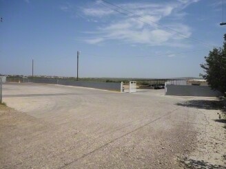
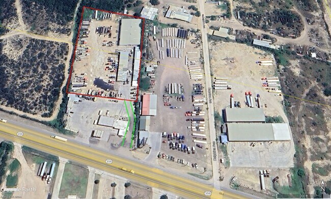

Property Detail
5908 State Highway 359
293408
SALINAS CANTU UNIT 1, BLOCK 1, LOT 1 & 2
Commercialnec
WEBB
M1
Texas
B and X Area of moderate flood hazard, usually the area between the limits of the 100-year and 500-year floods.
1,2
2024
3.37 AC
2025
Texas South Area
001826
Other Market Areas
4,540 SF
Laredo, TX
NEARBY LISTINGS FOR SALE OR LEASE
DEMOGRAPHICS near 5908 State Highway 359
1 mile
3 mile
5 mile
2025 Total Population
3,727
41,854
121,239
2030 Population
3,920
42,838
124,379
Pop Growth 2025-2030
+ 5.18%
+ 2.35%
+ 2.59%
Average Age
30
32
33
2025 Total Households
977
11,295
33,771
HH Growth 2025-2030
+ 5.42%
+ 2.48%
+ 2.70%
Median Household Inc
$98,772
$70,388
$54,620
Avg Household Size
3.90
3.60
3.50
2025 Avg HH Vehicles
3.00
2.00
2.00
Median Home Value
$219,624
$188,222
$177,260
Median Year Built
2008
2001
1996
Nearby Places
Map Layers
Map Styles
 Street
 Aerial
Transit
 Traffic
 Biking
Places
Listings with unknown addresses are not visible on the map
- Restaurants
- Banks
- Shops
- Fitness
- Groceries
PUBLIC TRANSPORTATION
AIRPORT
Laredo International
Drive
Walk
Distance
Laredo International
9 min
5.6 mi
Freight Ports
Port of Corpus Christi
Drive
Walk
Distance
Port of Corpus Christi
162 min
142.0 mi
SALE & LEASE HISTORY
LISTING DATE
SALE/LEASE

Feb 16, 2020
For Sale
Dec 27, 2024
For Lease
Nearby Properties
Address
Land Use
TOTAL SIZE
Lot Size
Zoning
Address
Land Use
TOTAL SIZE
Lot Size
Zoning
310,346 SF
87.65 AC
R1A
Address
Land Use
TOTAL SIZE
Lot Size
Zoning
347,773 SF
49.74 AC
R1
Address
Land Use
TOTAL SIZE
Lot Size
Zoning
380,420 SF
9.18 AC
B3
Address
Land Use
TOTAL SIZE
Lot Size
Zoning
169,339 SF
28 AC
Address
Land Use
TOTAL SIZE
Lot Size
Zoning
108,994 SF
15.39 AC
Address
Land Use
TOTAL SIZE
Lot Size
Zoning
107,824 SF
13.38 AC
R1
Address
Land Use
TOTAL SIZE
Lot Size
Zoning
96,665 SF
12.03 AC
R1A
Address
Land Use
TOTAL SIZE
Lot Size
Zoning
95,769 SF
10 AC
R1
Address
Land Use
TOTAL SIZE
Lot Size
Zoning
79,764 SF
30 AC
R1
Address
Land Use
TOTAL SIZE
Lot Size
Zoning
95,612 SF
10 AC
R1A
Address
Land Use
TOTAL SIZE
Lot Size
Zoning
136,195 SF
9.50 AC
Address
Land Use
TOTAL SIZE
Lot Size
Zoning
90,400 SF
1.77 AC
R3
Address
Land Use
TOTAL SIZE
Lot Size
Zoning
70,843 SF
20 AC
Address
Land Use
TOTAL SIZE
Lot Size
Zoning
81,470 SF
36.89 AC
Address
Land Use
TOTAL SIZE
Lot Size
Zoning
57,690 SF
8.98 AC
B4
Address
Land Use
TOTAL SIZE
Lot Size
Zoning
42,001 SF
6.01 AC
R1
Address
Land Use
TOTAL SIZE
Lot Size
Zoning
78,108 SF
14.80 AC
Address
Land Use
TOTAL SIZE
Lot Size
Zoning
221,975 SF
24.16 AC
B3
Address
Land Use
TOTAL SIZE
Lot Size
Zoning
124,154 SF
10.60 AC
B3
Address
Land Use
TOTAL SIZE
Lot Size
Zoning
42.64 AC
B3
Address
Land Use
TOTAL SIZE
Lot Size
Zoning
27,912 SF
18.98 AC
AG
Address
Land Use
TOTAL SIZE
Lot Size
Zoning
105,253 SF
16.02 AC
M1
Address
Land Use
TOTAL SIZE
Lot Size
Zoning
70,750 SF
9.42 AC
Address
Land Use
TOTAL SIZE
Lot Size
Zoning
45,862 SF
10.18 AC
Address
Land Use
TOTAL SIZE
Lot Size
Zoning
28,778 SF
10.33 AC
R1
Address
Land Use
TOTAL SIZE
Lot Size
Zoning
67,991 SF
3.74 AC
Address
Land Use
TOTAL SIZE
Lot Size
Zoning
50,754 SF
5.43 AC
B3
Address
Land Use
TOTAL SIZE
Lot Size
Zoning
69,806 SF
8.03 AC
M1
Address
Land Use
TOTAL SIZE
Lot Size
Zoning
27,507 SF
4.78 AC
Address
Land Use
TOTAL SIZE
Lot Size
Zoning
84,150 SF
5.78 AC
M1
The World's #1 Commercial Real Estate Marketplace
Connect with us
© 2026 CoStar Group
The information above has been obtained from sources believed reliable. While we do not doubt its accuracy we have not verified it and make no guarantee, warranty or representation about it. It is your responsibility to independently confirm its accuracy and completeness. Any projections, opinions, assumptions, or estimates used are for example only and do not represent the current or future performance of the property. The value of this transaction to you depends on tax and other factors which should be evaluated by your tax, financial, and legal advisors. You and your advisors should conduct a careful, independent investigation of the property to determine to your satisfaction the suitability of the property for your needs.