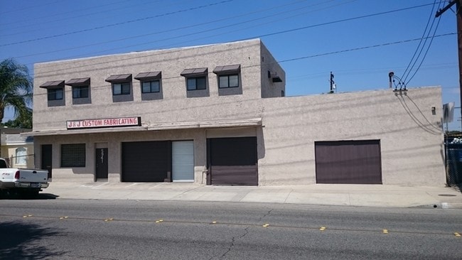
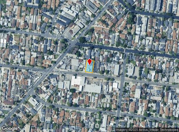
Property Record
5939 Clara St, Bell Gardens, CA 90201


Current Lease Availabilities
NEARBY LISTINGS FOR SALE OR LEASE
Property Detail
5939 Clara St
Los Angeles-Long Beach-Glendale, CA
I Heyman Tract
6228-007-014
I HEYMAN TRACT OF THE RANCHO SAN ANTONIO LOT ON N LINE OF CLARA ST PER L S 38-12 COM W THEREON 320 FT FROM W LINE OF GEHPART AVE TH W ON SD N LINE 80 FT WITH A UNIFORM DEPTH OF 130 FT N 7 1715 E PART OF LOT 7
Lightindustrial
Los Angeles
X
California
06037C1810F
7
2024
0.24 AC
2025
Commerce
533805
Los Angeles
8,378 SF
DEMOGRAPHICS near 5939 Clara St
1 Mile
3 Mile
5 Mile
2024 Total Population
34,909
251,223
746,446
2029 Population
32,585
238,721
711,747
Pop Growth 2024-2029
(6.66%)
(4.98%)
(4.65%)
Average Age
35
37
37
2024 Total Households
8,722
68,525
198,079
HH Growth 2024-2029
(7.02%)
(5.15%)
(4.91%)
Median Household Inc
$50,012
$63,377
$63,448
Avg Household Size
3.90
3.60
3.60
2024 Avg HH Vehicles
2.00
2.00
2.00
Median Home Value
$485,148
$635,924
$614,784
Median Year Built
1961
1956
1956
Nearby Places
Map Layers
Map Styles
 Street
 Aerial
- Restaurants
- Banks
- Shops
- Fitness
- Groceries
PUBLIC TRANSPORTATION
COMMUTER RAIL
Commerce (91 Line - Southern California Regional Rail Authority (Metrolink), Orange County Line - Southern California Regional Rail Authority (Metrolink))
DRIVE
WALK
Distance
Commerce (91 Line - Southern California Regional Rail Authority (Metrolink), Orange County Line - Southern California Regional Rail Authority (Metrolink))
9 min
2.8 mi
Montebello/Commerce (Riverside Line - Southern California Regional Rail Authority (Metrolink))
DRIVE
WALK
Distance
Montebello/Commerce (Riverside Line - Southern California Regional Rail Authority (Metrolink))
13 min
4.3 mi
AIRPORT
Long Beach (Daugherty Field)
DRIVE
WALK
Distance
Long Beach (Daugherty Field)
20 min
15.6 mi
Los Angeles International
DRIVE
WALK
Distance
Los Angeles International
24 min
19.7 mi
Bob Hope
DRIVE
WALK
Distance
Bob Hope
31 min
24.7 mi
Freight Ports
Port of Long Beach
DRIVE
WALK
Distance
Port of Long Beach
1 min
13.6 mi
Nearby Properties
Address
Land Use
TOTAL SIZE
Lot Size
Zoning
Address
Land Use
TOTAL SIZE
Lot Size
Zoning
313,224 SF
4.41 AC
SGM2*
Address
Land Use
TOTAL SIZE
Lot Size
Zoning
693,282 SF
30.34 AC
CMM2*
Address
Land Use
TOTAL SIZE
Lot Size
Zoning
397,549 SF
15.73 AC
CMM2*
Address
Land Use
TOTAL SIZE
Lot Size
Zoning
368,164 SF
7.82 AC
CMM2YY
Address
Land Use
TOTAL SIZE
Lot Size
Zoning
51,000 SF
27.18 AC
SGM3
Address
Land Use
TOTAL SIZE
Lot Size
Zoning
267,736 SF
9.04 AC
BGC4*
Address
Land Use
TOTAL SIZE
Lot Size
Zoning
609,466 SF
19.83 AC
CMM2*
Address
Land Use
TOTAL SIZE
Lot Size
Zoning
332,504 SF
7.76 AC
DOHM
Address
Land Use
TOTAL SIZE
Lot Size
Zoning
875,558 SF
24.08 AC
CMM2*
Address
Land Use
TOTAL SIZE
Lot Size
Zoning
841,076 SF
23.77 AC
CMM2*
Address
Land Use
TOTAL SIZE
Lot Size
Zoning
260,714 SF
9.99 AC
VEM*
Address
Land Use
TOTAL SIZE
Lot Size
Zoning
117,004 SF
6.27 AC
CMM2*
Address
Land Use
TOTAL SIZE
Lot Size
Zoning
168,548 SF
7.53 AC
CMM2*
Address
Land Use
TOTAL SIZE
Lot Size
Zoning
43,406 SF
5.67 AC
SGM2
Address
Land Use
TOTAL SIZE
Lot Size
Zoning
382,648 SF
14.73 AC
CMM2*
Address
Land Use
TOTAL SIZE
Lot Size
Zoning
175,443 SF
7.18 AC
BLCM*
Address
Land Use
TOTAL SIZE
Lot Size
Zoning
1,094,138 SF
23.73 AC
CMM2YY
Address
Land Use
TOTAL SIZE
Lot Size
Zoning
105,586 SF
9.96 AC
SGM3*
Address
Land Use
TOTAL SIZE
Lot Size
Zoning
118,026 SF
5.73 AC
CMM2*
Address
Land Use
TOTAL SIZE
Lot Size
Zoning
298,629 SF
6.93 AC
BGMPD*
Address
Land Use
TOTAL SIZE
Lot Size
Zoning
244,390 SF
12.99 AC
CMM2
Address
Land Use
TOTAL SIZE
Lot Size
Zoning
826,068 SF
21.11 AC
Address
Land Use
TOTAL SIZE
Lot Size
Zoning
289,422 SF
12.43 AC
CMM2*
Address
Land Use
TOTAL SIZE
Lot Size
Zoning
483,890 SF
12.45 AC
BLM*
Address
Land Use
TOTAL SIZE
Lot Size
Zoning
378,720 SF
13.08 AC
SGM3*
Address
Land Use
TOTAL SIZE
Lot Size
Zoning
97,218 SF
9.64 AC
SGM2
Address
Land Use
TOTAL SIZE
Lot Size
Zoning
102,761 SF
4.47 AC
CMM2YY
Address
Land Use
TOTAL SIZE
Lot Size
Zoning
506,144 SF
19.97 AC
CMM2*
Address
Land Use
TOTAL SIZE
Lot Size
Zoning
196,676 SF
9.80 AC
SGM3
Address
Land Use
TOTAL SIZE
Lot Size
Zoning
323,519 SF
19.54 AC
BLCM*
The World's #1 Commercial Real Estate Marketplace
Connect with us
© 2026 CoStar Group
The information above has been obtained from sources believed reliable. While we do not doubt its accuracy we have not verified it and make no guarantee, warranty or representation about it. It is your responsibility to independently confirm its accuracy and completeness. Any projections, opinions, assumptions, or estimates used are for example only and do not represent the current or future performance of the property. The value of this transaction to you depends on tax and other factors which should be evaluated by your tax, financial, and legal advisors. You and your advisors should conduct a careful, independent investigation of the property to determine to your satisfaction the suitability of the property for your needs.