Property Record
5930 Mcleod Dr, Las Vegas, NV 89120
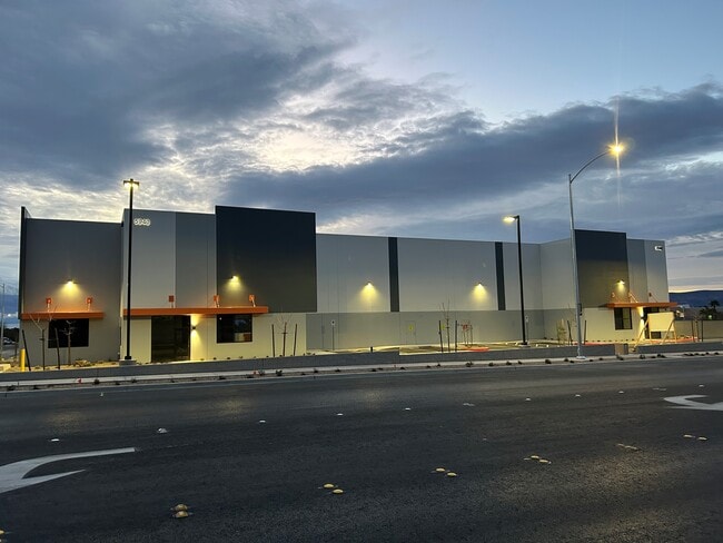
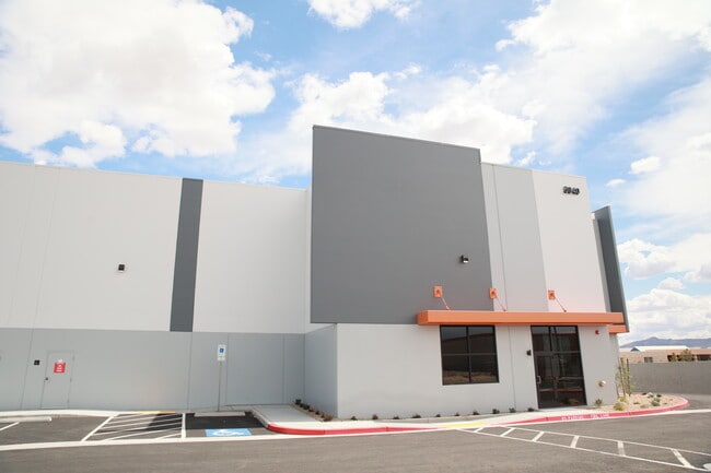
This Property Is For Sale
Current Lease Availabilities
NEARBY LISTINGS FOR SALE OR LEASE
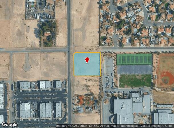
Property Detail
5930 Mcleod Dr
Las Vegas
Parcel Map File 130 Page 35
Las Vegas-Henderson-Paradise, NV
PARCEL MAP FILE 130 PAGE 35 LOT 1
162-36-601-056
Clark
Industrialgeneral
Nevada
0
1
2025
1.76 AC
006900
Airport/E Las Vegas
DEMOGRAPHICS near 5930 Mcleod Dr
1 Mile
3 Mile
5 Mile
2024 Total Population
7,923
140,819
417,365
2029 Population
8,626
153,255
455,192
Pop Growth 2024-2029
+ 8.87%
+ 8.83%
+ 9.06%
Average Age
44
41
41
2024 Total Households
3,187
57,216
170,845
HH Growth 2024-2029
+ 8.88%
+ 8.93%
+ 9.23%
Median Household Inc
$61,128
$54,859
$55,494
Avg Household Size
2.40
2.40
2.40
2024 Avg HH Vehicles
2.00
2.00
2.00
Median Home Value
$368,479
$362,289
$349,432
Median Year Built
1985
1985
1990
Nearby Places
Map Layers
Map Styles
 Street
 Aerial
- Restaurants
- Banks
- Shops
- Fitness
- Groceries
PUBLIC TRANSPORTATION
AIRPORT
Harry Reid International
DRIVE
WALK
Distance
Harry Reid International
7 min
3.0 mi
Boulder City Municipal
DRIVE
WALK
Distance
Boulder City Municipal
29 min
20.1 mi
Freight Ports
Port of Long Beach
DRIVE
WALK
Distance
Port of Long Beach
314 min
279.2 mi
Nearby Properties
Address
Land Use
TOTAL SIZE
Lot Size
Zoning
Address
Land Use
TOTAL SIZE
Lot Size
Zoning
79.03 AC
PF
Address
Land Use
TOTAL SIZE
Lot Size
Zoning
76.93 AC
PF
Address
Land Use
TOTAL SIZE
Lot Size
Zoning
138.07 AC
PF
Address
Land Use
TOTAL SIZE
Lot Size
Zoning
56.95 AC
PF
Address
Land Use
TOTAL SIZE
Lot Size
Zoning
44.69 AC
PF
Address
Land Use
TOTAL SIZE
Lot Size
Zoning
50,000 SF
72.01 AC
PF
Address
Land Use
TOTAL SIZE
Lot Size
Zoning
72.03 AC
PF
Address
Land Use
TOTAL SIZE
Lot Size
Zoning
399,206 SF
22.06 AC
MD
Address
Land Use
TOTAL SIZE
Lot Size
Zoning
95,928 SF
3.71 AC
C:U-V
Address
Land Use
TOTAL SIZE
Lot Size
Zoning
9,164 SF
22.81 AC
R3
Address
Land Use
TOTAL SIZE
Lot Size
Zoning
148.64 AC
PF
Address
Land Use
TOTAL SIZE
Lot Size
Zoning
513,085 SF
53.27 AC
C2
Address
Land Use
TOTAL SIZE
Lot Size
Zoning
100.25 AC
RS1
Address
Land Use
TOTAL SIZE
Lot Size
Zoning
8,891 SF
11.59 AC
Address
Land Use
TOTAL SIZE
Lot Size
Zoning
198.15 AC
PF
Address
Land Use
TOTAL SIZE
Lot Size
Zoning
4,460 SF
27.52 AC
Address
Land Use
TOTAL SIZE
Lot Size
Zoning
125,393 SF
12.33 AC
Address
Land Use
TOTAL SIZE
Lot Size
Zoning
160 AC
PF
Address
Land Use
TOTAL SIZE
Lot Size
Zoning
13,128 SF
47.47 AC
PF
Address
Land Use
TOTAL SIZE
Lot Size
Zoning
56,526 SF
12.44 AC
C2
Address
Land Use
TOTAL SIZE
Lot Size
Zoning
152.76 AC
PF
Address
Land Use
TOTAL SIZE
Lot Size
Zoning
100.43 AC
PF
Address
Land Use
TOTAL SIZE
Lot Size
Zoning
303,540 SF
4.99 AC
Address
Land Use
TOTAL SIZE
Lot Size
Zoning
554,741 SF
9.79 AC
C:MLZ
Address
Land Use
TOTAL SIZE
Lot Size
Zoning
213,048 SF
13.60 AC
Address
Land Use
TOTAL SIZE
Lot Size
Zoning
13,589 SF
56.80 AC
PF
Address
Land Use
TOTAL SIZE
Lot Size
Zoning
7,304 SF
12.58 AC
R4
Address
Land Use
TOTAL SIZE
Lot Size
Zoning
334,698 SF
18.44 AC
MD
Address
Land Use
TOTAL SIZE
Lot Size
Zoning
3,040 SF
16.76 AC
R4
Address
Land Use
TOTAL SIZE
Lot Size
Zoning
6,548 SF
15.75 AC
RH24
The World's #1 Commercial Real Estate Marketplace
Connect with us
© 2025 CoStar Group
The information above has been obtained from sources believed reliable. While we do not doubt its accuracy we have not verified it and make no guarantee, warranty or representation about it. It is your responsibility to independently confirm its accuracy and completeness. Any projections, opinions, assumptions, or estimates used are for example only and do not represent the current or future performance of the property. The value of this transaction to you depends on tax and other factors which should be evaluated by your tax, financial, and legal advisors. You and your advisors should conduct a careful, independent investigation of the property to determine to your satisfaction the suitability of the property for your needs.