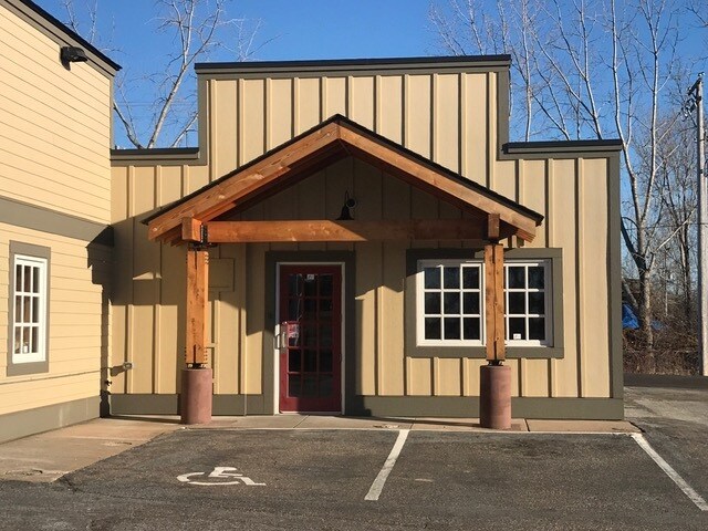
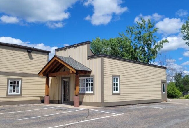
Property Record
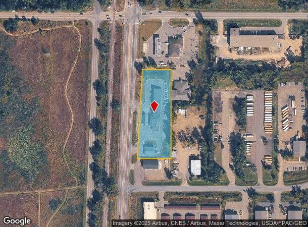
5960 Highway 61 N, Saint Paul, MN 55110
NEARBY LISTINGS FOR SALE OR LEASE
Property Detail
5960 Highway 61 N
Minneapolis-St. Paul-Bloomington, MN-WI
Robert G. Mackays Bald,Eagle
01-30-22-22-0004
ROBERT G. MACKAYS BALD,EAGLE SUBJ TO HWY & EX S 128.5 FT; LOT 7
Stripcommercialcenter
Ramsey
X
Minnesota
27003C0450E
7
2024
1.95 AC
2025
Maplewood
040102
Minneapolis/St Paul
11,824 SF
DEMOGRAPHICS near 5960 Highway 61 N
1 Mile
3 Mile
5 Mile
2024 Total Population
2,315
25,338
70,080
2029 Population
2,375
25,897
71,702
Pop Growth 2024-2029
+ 2.59%
+ 2.21%
+ 2.31%
Average Age
43
42
42
2024 Total Households
825
9,635
27,295
HH Growth 2024-2029
+ 2.42%
+ 1.77%
+ 2.00%
Median Household Inc
$145,926
$118,717
$107,944
Avg Household Size
2.70
2.60
2.50
2024 Avg HH Vehicles
3.00
2.00
2.00
Median Home Value
$385,947
$378,127
$366,395
Median Year Built
1991
1988
1985
Nearby Places
Map Layers
Map Styles
 Street
 Aerial
- Restaurants
- Banks
- Shops
- Fitness
- Groceries
PUBLIC TRANSPORTATION
AIRPORT
Minneapolis-St Paul International/Wold-Chamberlain
DRIVE
WALK
Distance
Minneapolis-St Paul International/Wold-Chamberlain
37 min
24.2 mi
SALE & LEASE HISTORY
LISTING DATE
SALE/LEASE

Nov 05, 2020
For Lease
Mar 27, 2025
For Lease
Mar 11, 2025
For Lease
Jun 11, 2024
For Lease
Feb 17, 2023
For Lease
Nearby Properties
Address
Land Use
TOTAL SIZE
Lot Size
Zoning
Address
Land Use
TOTAL SIZE
Lot Size
Zoning
175,536 SF
7.60 AC
Address
Land Use
TOTAL SIZE
Lot Size
Zoning
78,163 SF
5.62 AC
Address
Land Use
TOTAL SIZE
Lot Size
Zoning
402,000 SF
27.86 AC
Address
Land Use
TOTAL SIZE
Lot Size
Zoning
960 SF
17.11 AC
Address
Land Use
TOTAL SIZE
Lot Size
Zoning
13,358 SF
311.47 AC
W8OPSP
Address
Land Use
TOTAL SIZE
Lot Size
Zoning
Address
Land Use
TOTAL SIZE
Lot Size
Zoning
3,200 SF
14.31 AC
W7PUBLC
Address
Land Use
TOTAL SIZE
Lot Size
Zoning
99,207 SF
5 AC
Address
Land Use
TOTAL SIZE
Lot Size
Zoning
202,460 SF
26.72 AC
Address
Land Use
TOTAL SIZE
Lot Size
Zoning
234,156 SF
12.01 AC
Address
Land Use
TOTAL SIZE
Lot Size
Zoning
82,403 SF
41.35 AC
Address
Land Use
TOTAL SIZE
Lot Size
Zoning
57,522 SF
8.63 AC
Address
Land Use
TOTAL SIZE
Lot Size
Zoning
128,462 SF
2.07 AC
Address
Land Use
TOTAL SIZE
Lot Size
Zoning
163,329 SF
11.36 AC
Address
Land Use
TOTAL SIZE
Lot Size
Zoning
Address
Land Use
TOTAL SIZE
Lot Size
Zoning
132,487 SF
2.19 AC
Address
Land Use
TOTAL SIZE
Lot Size
Zoning
136,800 SF
Address
Land Use
TOTAL SIZE
Lot Size
Zoning
130,104 SF
3.35 AC
Address
Land Use
TOTAL SIZE
Lot Size
Zoning
40,036 SF
18.45 AC
Address
Land Use
TOTAL SIZE
Lot Size
Zoning
1,920 SF
42.80 AC
Address
Land Use
TOTAL SIZE
Lot Size
Zoning
128,364 SF
19.10 AC
Address
Land Use
TOTAL SIZE
Lot Size
Zoning
145,704 SF
7.05 AC
Address
Land Use
TOTAL SIZE
Lot Size
Zoning
137,960 SF
20 AC
Address
Land Use
TOTAL SIZE
Lot Size
Zoning
155,674 SF
10.60 AC
Address
Land Use
TOTAL SIZE
Lot Size
Zoning
Address
Land Use
TOTAL SIZE
Lot Size
Zoning
55,000 SF
Address
Land Use
TOTAL SIZE
Lot Size
Zoning
162,486 SF
12.44 AC
Address
Land Use
TOTAL SIZE
Lot Size
Zoning
23,779 SF
6.21 AC
Address
Land Use
TOTAL SIZE
Lot Size
Zoning
100,383 SF
5.75 AC
Address
Land Use
TOTAL SIZE
Lot Size
Zoning
202,000 SF
11.43 AC
The World's #1 Commercial Real Estate Marketplace
Connect with us
© 2025 CoStar Group
The information above has been obtained from sources believed reliable. While we do not doubt its accuracy we have not verified it and make no guarantee, warranty or representation about it. It is your responsibility to independently confirm its accuracy and completeness. Any projections, opinions, assumptions, or estimates used are for example only and do not represent the current or future performance of the property. The value of this transaction to you depends on tax and other factors which should be evaluated by your tax, financial, and legal advisors. You and your advisors should conduct a careful, independent investigation of the property to determine to your satisfaction the suitability of the property for your needs.