Property Record
599 8Th St, Beaver, PA 15009
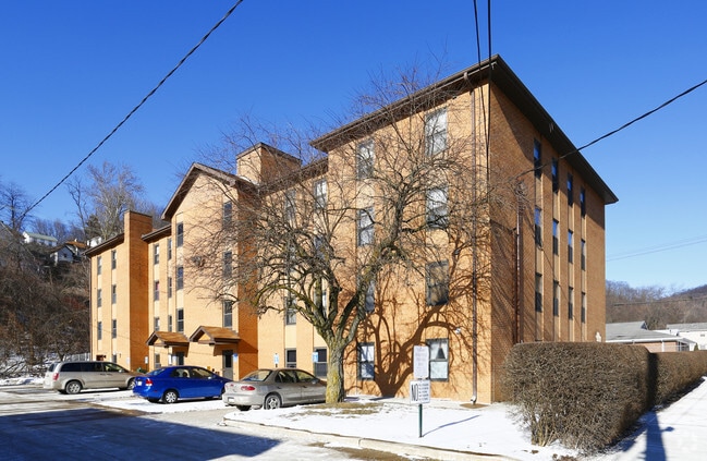

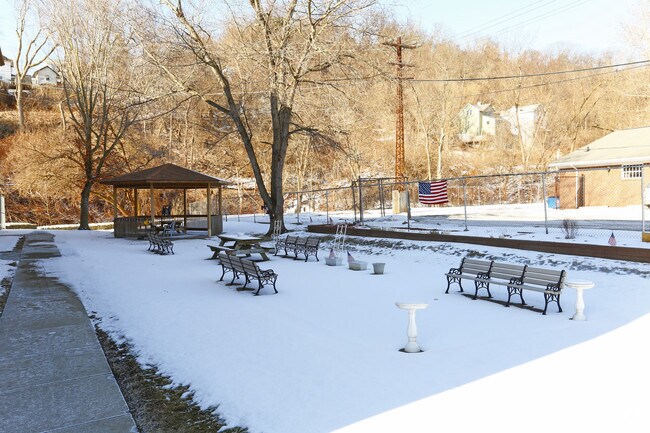
Property Detail
599 8Th St
Pittsburgh, PA
LOTS 134 135 136 VIC PL BLDG
26-001-0545.000
BEAVER
Apartment
Pennsylvania
AE The base floodplain where base flood elevations are provided. AE Zones are now used on new format FIRMs instead of A1-A30 Zones.
134
2024
0.49 AC
2025
Outlying Beaver County
602602
Pittsburgh
10,769 SF
NEARBY LISTINGS FOR SALE OR LEASE
DEMOGRAPHICS near 599 8Th St
1 mile
3 mile
5 mile
2025 Total Population
3,164
26,266
64,217
2030 Population
3,146
26,048
63,759
Pop Growth 2025-2030
(0.57%)
(0.83%)
(0.71%)
Average Age
41
44
45
2025 Total Households
1,327
11,715
28,360
HH Growth 2025-2030
(0.60%)
(0.87%)
(0.75%)
Median Household Inc
$63,750
$63,527
$64,598
Avg Household Size
2.40
2.20
2.20
2025 Avg HH Vehicles
2.00
2.00
2.00
Median Home Value
$152,934
$183,106
$193,144
Median Year Built
1949
1955
1956
Nearby Places
Map Layers
Map Styles
 Street
 Aerial
Layers
 Traffic
 Biking
Places
Listings with unknown addresses are not visible on the map
- Restaurants
- Banks
- Shops
- Fitness
- Groceries
PUBLIC TRANSPORTATION
AIRPORT
Pittsburgh International
Drive
Walk
Distance
Pittsburgh International
29 min
16.0 mi
Nearby Properties
Address
Land Use
TOTAL SIZE
Lot Size
Zoning
Address
Land Use
TOTAL SIZE
Lot Size
Zoning
14,636 SF
81.19 AC
Address
Land Use
TOTAL SIZE
Lot Size
Zoning
27,924 SF
20.53 AC
Address
Land Use
TOTAL SIZE
Lot Size
Zoning
207,313 SF
10.68 AC
Address
Land Use
TOTAL SIZE
Lot Size
Zoning
6.68 AC
Address
Land Use
TOTAL SIZE
Lot Size
Zoning
9,594 SF
3.69 AC
Address
Land Use
TOTAL SIZE
Lot Size
Zoning
190.71 AC
Address
Land Use
TOTAL SIZE
Lot Size
Zoning
94,635 SF
29.13 AC
Address
Land Use
TOTAL SIZE
Lot Size
Zoning
77,728 SF
14.20 AC
Address
Land Use
TOTAL SIZE
Lot Size
Zoning
90,036 SF
13.26 AC
Address
Land Use
TOTAL SIZE
Lot Size
Zoning
14.82 AC
Address
Land Use
TOTAL SIZE
Lot Size
Zoning
42,645 SF
24.46 AC
Address
Land Use
TOTAL SIZE
Lot Size
Zoning
9.89 AC
Address
Land Use
TOTAL SIZE
Lot Size
Zoning
14.23 AC
Address
Land Use
TOTAL SIZE
Lot Size
Zoning
75.39 AC
Address
Land Use
TOTAL SIZE
Lot Size
Zoning
13,026 SF
27.67 AC
Address
Land Use
TOTAL SIZE
Lot Size
Zoning
60,250 SF
60.17 AC
Address
Land Use
TOTAL SIZE
Lot Size
Zoning
104.08 AC
Address
Land Use
TOTAL SIZE
Lot Size
Zoning
72,256 SF
10.37 AC
Address
Land Use
TOTAL SIZE
Lot Size
Zoning
70,548 SF
2 AC
Address
Land Use
TOTAL SIZE
Lot Size
Zoning
1,980 SF
9.33 AC
Address
Land Use
TOTAL SIZE
Lot Size
Zoning
14,903 SF
25 AC
Address
Land Use
TOTAL SIZE
Lot Size
Zoning
18.90 AC
Address
Land Use
TOTAL SIZE
Lot Size
Zoning
22.38 AC
Address
Land Use
TOTAL SIZE
Lot Size
Zoning
37,190 SF
0.52 AC
Address
Land Use
TOTAL SIZE
Lot Size
Zoning
45,215 SF
45.95 AC
Address
Land Use
TOTAL SIZE
Lot Size
Zoning
0.92 AC
Address
Land Use
TOTAL SIZE
Lot Size
Zoning
1.01 AC
Address
Land Use
TOTAL SIZE
Lot Size
Zoning
11,714 SF
119.52 AC
Address
Land Use
TOTAL SIZE
Lot Size
Zoning
8.99 AC
Address
Land Use
TOTAL SIZE
Lot Size
Zoning
5,802 SF
1.40 AC
The World's #1 Commercial Real Estate Marketplace
Connect with us
© 2026 CoStar Group
The information above has been obtained from sources believed reliable. While we do not doubt its accuracy we have not verified it and make no guarantee, warranty or representation about it. It is your responsibility to independently confirm its accuracy and completeness. Any projections, opinions, assumptions, or estimates used are for example only and do not represent the current or future performance of the property. The value of this transaction to you depends on tax and other factors which should be evaluated by your tax, financial, and legal advisors. You and your advisors should conduct a careful, independent investigation of the property to determine to your satisfaction the suitability of the property for your needs.