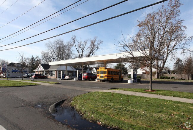
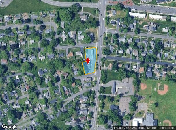
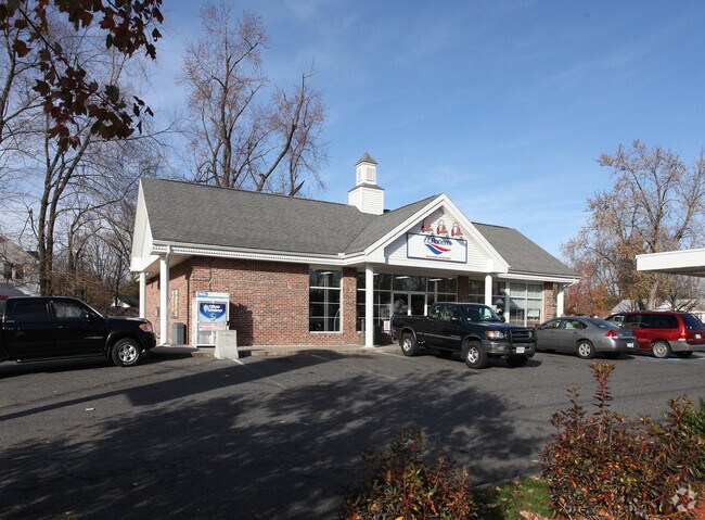
Property Record
6 Lealand Ave, Agawam, MA 01001
NEARBY LISTINGS FOR SALE OR LEASE
Property Detail
6 Lealand Ave
AGAW-000010K-000010-000006
Hampden
Commercialnec
Massachusetts
X
6
25013C0403E
0.65 AC
2025
Hampden County
2025
Hartford
813209
Springfield, MA
3,100 SF
DEMOGRAPHICS near 6 Lealand Ave
1 Mile
3 Mile
5 Mile
2024 Total Population
5,862
66,131
189,735
2029 Population
5,675
64,755
186,237
Pop Growth 2024-2029
(3.19%)
(2.08%)
(1.84%)
Average Age
46
39
39
2024 Total Households
2,395
27,643
73,528
HH Growth 2024-2029
(3.42%)
(2.10%)
(1.89%)
Median Household Inc
$76,156
$48,658
$57,234
Avg Household Size
2.20
2.30
2.40
2024 Avg HH Vehicles
2.00
1.00
1.00
Median Home Value
$270,466
$270,464
$255,143
Median Year Built
1969
1953
1953
Nearby Places
Map Layers
Map Styles
 Street
 Aerial
- Restaurants
- Banks
- Shops
- Fitness
- Groceries
PUBLIC TRANSPORTATION
COMMUTER RAIL
Springfield (Amtrak Hartford Line - Amtrak, Hartford Line - Amtrak, Lake Shore Limited - Amtrak, Northeast Regional - Amtrak, Valley Flyer - Amtrak, Vermonter - Amtrak)
DRIVE
WALK
Distance
Springfield (Amtrak Hartford Line - Amtrak, Hartford Line - Amtrak, Lake Shore Limited - Amtrak, Northeast Regional - Amtrak, Valley Flyer - Amtrak, Vermonter - Amtrak)
6 min
3.8 mi
AIRPORT
Bradley International
DRIVE
WALK
Distance
Bradley International
26 min
10.8 mi
Freight Ports
Port of New Haven
DRIVE
WALK
Distance
Port of New Haven
83 min
64.8 mi
Nearby Properties
Address
Land Use
TOTAL SIZE
Lot Size
Zoning
Address
Land Use
TOTAL SIZE
Lot Size
Zoning
162,232 SF
3.06 AC
R2
Address
Land Use
TOTAL SIZE
Lot Size
Zoning
82,248 SF
4.57 AC
SR3C1
Address
Land Use
TOTAL SIZE
Lot Size
Zoning
227,072 SF
4.37 AC
B3
Address
Land Use
TOTAL SIZE
Lot Size
Zoning
839,347 SF
2.05 AC
B3
Address
Land Use
TOTAL SIZE
Lot Size
Zoning
36.53 AC
IB
Address
Land Use
TOTAL SIZE
Lot Size
Zoning
200,000 SF
13.91 AC
R3
Address
Land Use
TOTAL SIZE
Lot Size
Zoning
100,000 SF
17.80 AC
WC
Address
Land Use
TOTAL SIZE
Lot Size
Zoning
236,032 SF
41.65 AC
RA2
Address
Land Use
TOTAL SIZE
Lot Size
Zoning
8,712 SF
25.08 AC
RA1
Address
Land Use
TOTAL SIZE
Lot Size
Zoning
115,600 SF
4.25 AC
B2
Address
Land Use
TOTAL SIZE
Lot Size
Zoning
42,412 SF
2.22 AC
SR2B1
Address
Land Use
TOTAL SIZE
Lot Size
Zoning
24,835 SF
2.16 AC
B3
Address
Land Use
TOTAL SIZE
Lot Size
Zoning
335,105 SF
1.28 AC
B3
Address
Land Use
TOTAL SIZE
Lot Size
Zoning
186,700 SF
11.17 AC
SR3R5
Address
Land Use
TOTAL SIZE
Lot Size
Zoning
1,840 SF
148.78 AC
BB
Address
Land Use
TOTAL SIZE
Lot Size
Zoning
77,012 SF
1.29 AC
B3
Address
Land Use
TOTAL SIZE
Lot Size
Zoning
4,400 SF
675 AC
SR1R2
Address
Land Use
TOTAL SIZE
Lot Size
Zoning
137,450 SF
16 AC
Address
Land Use
TOTAL SIZE
Lot Size
Zoning
57,593 SF
2.15 AC
SR3C1
Address
Land Use
TOTAL SIZE
Lot Size
Zoning
184,850 SF
2.39 AC
B3
Address
Land Use
TOTAL SIZE
Lot Size
Zoning
229,164 SF
3.80 AC
R5
Address
Land Use
TOTAL SIZE
Lot Size
Zoning
426,795 SF
3.99 AC
B3
Address
Land Use
TOTAL SIZE
Lot Size
Zoning
126,360 SF
3.39 AC
SB1B2
Address
Land Use
TOTAL SIZE
Lot Size
Zoning
171,105 SF
14.21 AC
Address
Land Use
TOTAL SIZE
Lot Size
Zoning
155,803 SF
0.87 AC
B3
Address
Land Use
TOTAL SIZE
Lot Size
Zoning
183,248 SF
4.47 AC
R4
Address
Land Use
TOTAL SIZE
Lot Size
Zoning
74,634 SF
1.37 AC
R3
Address
Land Use
TOTAL SIZE
Lot Size
Zoning
51,400 SF
0.59 AC
B3
Address
Land Use
TOTAL SIZE
Lot Size
Zoning
85,000 SF
0.16 AC
R3
Address
Land Use
TOTAL SIZE
Lot Size
Zoning
80,144 SF
CR
The World's #1 Commercial Real Estate Marketplace
Connect with us
© 2025 CoStar Group
The information above has been obtained from sources believed reliable. While we do not doubt its accuracy we have not verified it and make no guarantee, warranty or representation about it. It is your responsibility to independently confirm its accuracy and completeness. Any projections, opinions, assumptions, or estimates used are for example only and do not represent the current or future performance of the property. The value of this transaction to you depends on tax and other factors which should be evaluated by your tax, financial, and legal advisors. You and your advisors should conduct a careful, independent investigation of the property to determine to your satisfaction the suitability of the property for your needs.