Property Record
600 Army Navy Dr, Arlington, VA 22202
NEARBY LISTINGS FOR SALE OR LEASE
Property Detail
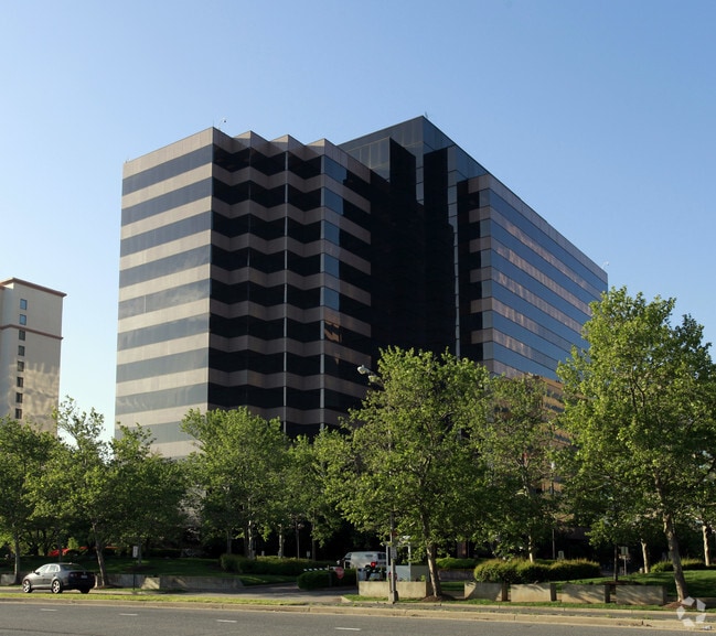
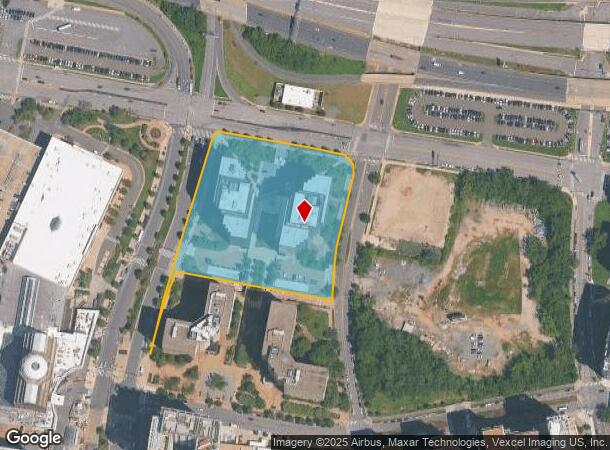
600 Army Navy Dr
Washington-Arlington-Alexandria, DC-VA-MD-WV
Street Building
35-004-007
PARC 1-C RESUB PT PARC B-2-B PROP OF AMBASSADOR INC & H STREET BUILDING CORPORATION 205,824.0492 SQ FT
Officebuilding
Arlington
X
Virginia
5155190031F
7
2025
4.72 AC
2025
Pentagon City
103505
Washington, DC
514,892 SF
DEMOGRAPHICS near 600 Army Navy Dr
1 Mile
3 Mile
5 Mile
2024 Total Population
26,040
238,277
795,038
2029 Population
25,736
232,552
755,344
Pop Growth 2024-2029
(1.17%)
(2.40%)
(4.99%)
Average Age
38
37
37
2024 Total Households
14,693
120,052
378,674
HH Growth 2024-2029
(1.18%)
(2.73%)
(5.55%)
Median Household Inc
$122,681
$117,092
$107,159
Avg Household Size
1.70
1.90
2.00
2024 Avg HH Vehicles
1.00
1.00
1.00
Median Home Value
$736,506
$697,345
$710,538
Median Year Built
1987
1982
1969
Nearby Places
Map Layers
Map Styles
 Street
 Aerial
- Restaurants
- Banks
- Shops
- Fitness
- Groceries
PUBLIC TRANSPORTATION
TRANSIT/SUBWAY
Pentagon City (Blue Line - Washington Metropolitan Area Transit Authority Metrorail (Metrorail), Yellow Line - Washington Metropolitan Area Transit Authority Metrorail (Metrorail))
DRIVE
WALK
Distance
Pentagon City (Blue Line - Washington Metropolitan Area Transit Authority Metrorail (Metrorail), Yellow Line - Washington Metropolitan Area Transit Authority Metrorail (Metrorail))
1 min
4 min
0.2 mi
Pentagon (Blue Line - Washington Metropolitan Area Transit Authority Metrorail (Metrorail), Yellow Line - Washington Metropolitan Area Transit Authority Metrorail (Metrorail))
DRIVE
WALK
Distance
Pentagon (Blue Line - Washington Metropolitan Area Transit Authority Metrorail (Metrorail), Yellow Line - Washington Metropolitan Area Transit Authority Metrorail (Metrorail))
3 min
8 min
0.4 mi
Crystal City (Blue Line - Washington Metropolitan Area Transit Authority Metrorail (Metrorail), Yellow Line - Washington Metropolitan Area Transit Authority Metrorail (Metrorail))
DRIVE
WALK
Distance
Crystal City (Blue Line - Washington Metropolitan Area Transit Authority Metrorail (Metrorail), Yellow Line - Washington Metropolitan Area Transit Authority Metrorail (Metrorail))
2 min
15 min
0.8 mi
Crystal City (Fredericksburg Line - Virginia Railway Express, Manassas Line - Virginia Railway Express)
DRIVE
WALK
Distance
Crystal City (Fredericksburg Line - Virginia Railway Express, Manassas Line - Virginia Railway Express)
3 min
16 min
0.8 mi
COMMUTER RAIL
Crystal City (Fredericksburg Line - Virginia Railway Express, Manassas Line - Virginia Railway Express)
DRIVE
WALK
Distance
Crystal City (Fredericksburg Line - Virginia Railway Express, Manassas Line - Virginia Railway Express)
3 min
16 min
0.8 mi
DRIVE
WALK
Distance
6 min
3.0 mi
AIRPORT
Ronald Reagan Washington Ntl
DRIVE
WALK
Distance
Ronald Reagan Washington Ntl
6 min
2.2 mi
Washington Dulles International
DRIVE
WALK
Distance
Washington Dulles International
45 min
26.1 mi
Baltimore/Washington International Thurgood Marshall
DRIVE
WALK
Distance
Baltimore/Washington International Thurgood Marshall
53 min
34.9 mi
Freight Ports
Port of Baltimore
DRIVE
WALK
Distance
Port of Baltimore
62 min
42.1 mi
Nearby Properties
Address
Land Use
TOTAL SIZE
Lot Size
Zoning
Address
Land Use
TOTAL SIZE
Lot Size
Zoning
900,000 SF
11.10 AC
S-3A
Address
Land Use
TOTAL SIZE
Lot Size
Zoning
2,052,109 SF
90.60 AC
UNZONED
Address
Land Use
TOTAL SIZE
Lot Size
Zoning
128,439 SF
373.22 AC
UNZONED
Address
Land Use
TOTAL SIZE
Lot Size
Zoning
533,778 SF
18.08 AC
UNZONED
Address
Land Use
TOTAL SIZE
Lot Size
Zoning
5,483 SF
88.76 AC
GOV
Address
Land Use
TOTAL SIZE
Lot Size
Zoning
1,517,010 SF
70.25 AC
UNZONED
Address
Land Use
TOTAL SIZE
Lot Size
Zoning
142 AC
GOV
Address
Land Use
TOTAL SIZE
Lot Size
Zoning
2,493,936 SF
8.99 AC
UNZONED
Address
Land Use
TOTAL SIZE
Lot Size
Zoning
3.71 AC
UNZONED
Address
Land Use
TOTAL SIZE
Lot Size
Zoning
63.89 AC
GOV
Address
Land Use
TOTAL SIZE
Lot Size
Zoning
19.46 AC
CG-4
Address
Land Use
TOTAL SIZE
Lot Size
Zoning
3,750,395 SF
10.82 AC
UNZONED
Address
Land Use
TOTAL SIZE
Lot Size
Zoning
262,673 SF
5.35 AC
D-7
Address
Land Use
TOTAL SIZE
Lot Size
Zoning
1,530,865 SF
6.05 AC
D-6;UNZONE
Address
Land Use
TOTAL SIZE
Lot Size
Zoning
6,500,000 SF
92.03 AC
S-3A
Address
Land Use
TOTAL SIZE
Lot Size
Zoning
42.57 AC
GOV
Address
Land Use
TOTAL SIZE
Lot Size
Zoning
2,455,000 SF
11.08 AC
MU-2
Address
Land Use
TOTAL SIZE
Lot Size
Zoning
52.44 AC
UNZONED
Address
Land Use
TOTAL SIZE
Lot Size
Zoning
1,100,000 SF
2.13 AC
D-6
Address
Land Use
TOTAL SIZE
Lot Size
Zoning
1,310,661 SF
3.38 AC
D-6
Address
Land Use
TOTAL SIZE
Lot Size
Zoning
1,336,013 SF
5.41 AC
D-5
Address
Land Use
TOTAL SIZE
Lot Size
Zoning
1,738,573 SF
2.11 AC
D-7
Address
Land Use
TOTAL SIZE
Lot Size
Zoning
1,081,367 SF
6.46 AC
UNZONED
Address
Land Use
TOTAL SIZE
Lot Size
Zoning
1.57 AC
D-5
Address
Land Use
TOTAL SIZE
Lot Size
Zoning
1,015,833 SF
1.60 AC
D-7
Address
Land Use
TOTAL SIZE
Lot Size
Zoning
782,765 SF
94.06 AC
CG-5;CG-6;
Address
Land Use
TOTAL SIZE
Lot Size
Zoning
1,185,122 SF
2.43 AC
D-6
Address
Land Use
TOTAL SIZE
Lot Size
Zoning
4.95 AC
UNZONED
Address
Land Use
TOTAL SIZE
Lot Size
Zoning
1,214,044 SF
1.48 AC
D-6
Address
Land Use
TOTAL SIZE
Lot Size
Zoning
1,375,218 SF
3.55 AC
D-4
The World's #1 Commercial Real Estate Marketplace
Connect with us
© 2026 CoStar Group
The information above has been obtained from sources believed reliable. While we do not doubt its accuracy we have not verified it and make no guarantee, warranty or representation about it. It is your responsibility to independently confirm its accuracy and completeness. Any projections, opinions, assumptions, or estimates used are for example only and do not represent the current or future performance of the property. The value of this transaction to you depends on tax and other factors which should be evaluated by your tax, financial, and legal advisors. You and your advisors should conduct a careful, independent investigation of the property to determine to your satisfaction the suitability of the property for your needs.