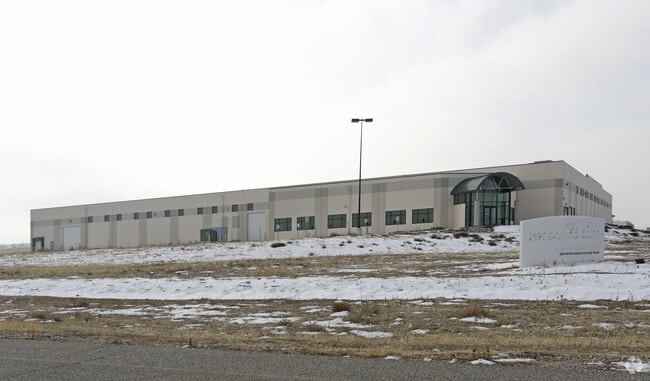
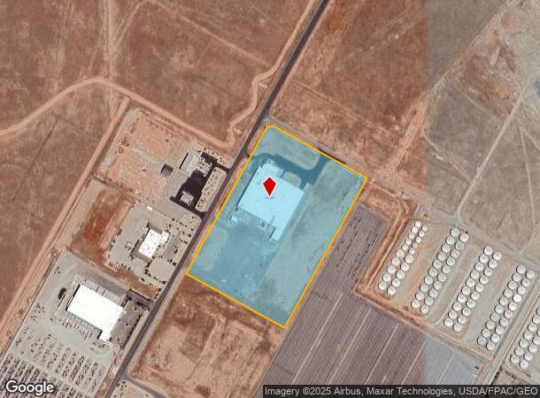
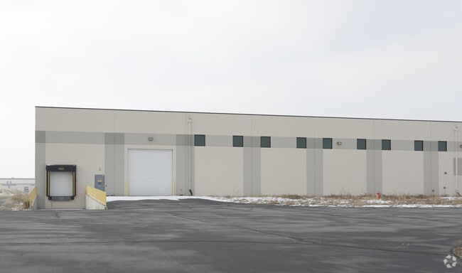
Property Record
600 N Industrial Loop Rd, Tooele, UT 84074

NEARBY LISTINGS FOR SALE OR LEASE
Property Detail
600 N Industrial Loop Rd
Salt Lake City-Murray, UT
Minor Sub
16-005-0-0100
LOT 100, UTAH INDUSTRIAL DEPOT SUB #1 AMENDED (MINOR SUB), A SUBDIVISION OF TOOELE CITY. OUT OF 14-32-101, 14-32-102 AND 2-13
Commercialnec
Tooele
D
Utah
49045C1640C
100
2025
20 AC
2025
Tooele County
130708
Salt Lake City
114,155 SF
DEMOGRAPHICS near 600 N Industrial Loop Rd
1 mile
3 mile
5 mile
2024 Total Population
8
25,979
44,585
2029 Population
10
32,561
55,814
Pop Growth 2024-2029
+ 25.00%
+ 25.34%
+ 25.19%
Average Age
25
34
34
2024 Total Households
2
8,467
14,163
HH Growth 2024-2029
+ 50.00%
+ 25.69%
+ 25.57%
Median Household Inc
$87,500
$83,409
$88,316
Avg Household Size
2.00
3.00
3.10
2024 Avg HH Vehicles
2.00
2.00
3.00
Median Home Value
$399,999
$289,478
$298,396
Median Year Built
2010
1996
1996
Nearby Places
Map Layers
Map Styles
 Street
 Aerial
Transit
 Traffic
 Biking
Places
Listings with unknown addresses are not visible on the map
- Restaurants
- Banks
- Shops
- Fitness
- Groceries
PUBLIC TRANSPORTATION
AIRPORT
Salt Lake City International
Drive
Walk
Distance
Salt Lake City International
42 min
31.8 mi
SALE & LEASE HISTORY
LISTING DATE
SALE/LEASE

Sep 25, 2016
For Lease
Sep 24, 2016
For Sale
Sep 24, 2016
For Sale
Nov 14, 2016
For Sale
May 28, 2019
For Lease
Mar 30, 2017
For Sale
Jan 21, 2021
For Lease
Jan 21, 2021
For Sale
Nearby Properties
Address
Land Use
TOTAL SIZE
Lot Size
Zoning
Address
Land Use
TOTAL SIZE
Lot Size
Zoning
205,900 SF
107.47 AC
Address
Land Use
TOTAL SIZE
Lot Size
Zoning
8.47 AC
Address
Land Use
TOTAL SIZE
Lot Size
Zoning
610,536 SF
48.93 AC
Address
Land Use
TOTAL SIZE
Lot Size
Zoning
263,948 SF
47.90 AC
Address
Land Use
TOTAL SIZE
Lot Size
Zoning
8.32 AC
Address
Land Use
TOTAL SIZE
Lot Size
Zoning
57,218 SF
186.98 AC
Address
Land Use
TOTAL SIZE
Lot Size
Zoning
3,220 SF
7.40 AC
Address
Land Use
TOTAL SIZE
Lot Size
Zoning
339,571 SF
35.61 AC
Address
Land Use
TOTAL SIZE
Lot Size
Zoning
166,140 SF
7 AC
Address
Land Use
TOTAL SIZE
Lot Size
Zoning
90,340 SF
41.76 AC
Address
Land Use
TOTAL SIZE
Lot Size
Zoning
14,400 SF
5.48 AC
Address
Land Use
TOTAL SIZE
Lot Size
Zoning
3,188 SF
7.64 AC
Address
Land Use
TOTAL SIZE
Lot Size
Zoning
59,286 SF
4.84 AC
Address
Land Use
TOTAL SIZE
Lot Size
Zoning
140,412 SF
10.38 AC
Address
Land Use
TOTAL SIZE
Lot Size
Zoning
86,615 SF
8.87 AC
Address
Land Use
TOTAL SIZE
Lot Size
Zoning
5.34 AC
Address
Land Use
TOTAL SIZE
Lot Size
Zoning
191,115 SF
18.09 AC
Address
Land Use
TOTAL SIZE
Lot Size
Zoning
3.50 AC
Address
Land Use
TOTAL SIZE
Lot Size
Zoning
55,381 SF
4.68 AC
Address
Land Use
TOTAL SIZE
Lot Size
Zoning
59,960 SF
16.45 AC
Address
Land Use
TOTAL SIZE
Lot Size
Zoning
191,148 SF
11.08 AC
Address
Land Use
TOTAL SIZE
Lot Size
Zoning
60,127 SF
1.67 AC
Address
Land Use
TOTAL SIZE
Lot Size
Zoning
25,238 SF
3.26 AC
Address
Land Use
TOTAL SIZE
Lot Size
Zoning
53,151 SF
1.18 AC
Address
Land Use
TOTAL SIZE
Lot Size
Zoning
2,540 SF
2.25 AC
Address
Land Use
TOTAL SIZE
Lot Size
Zoning
24,550 SF
0.86 AC
Address
Land Use
TOTAL SIZE
Lot Size
Zoning
60,169 SF
40.57 AC
Address
Land Use
TOTAL SIZE
Lot Size
Zoning
29,667 SF
6.48 AC
The World's #1 Commercial Real Estate Marketplace
Connect with us
© 2026 CoStar Group
The information above has been obtained from sources believed reliable. While we do not doubt its accuracy we have not verified it and make no guarantee, warranty or representation about it. It is your responsibility to independently confirm its accuracy and completeness. Any projections, opinions, assumptions, or estimates used are for example only and do not represent the current or future performance of the property. The value of this transaction to you depends on tax and other factors which should be evaluated by your tax, financial, and legal advisors. You and your advisors should conduct a careful, independent investigation of the property to determine to your satisfaction the suitability of the property for your needs.