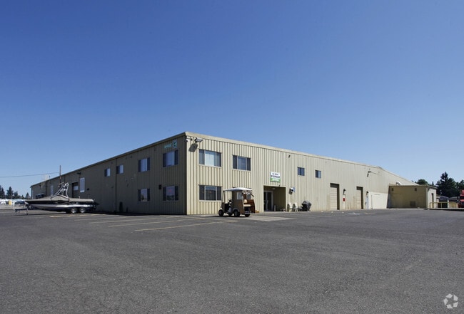
Property Record
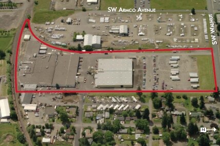
600 Sw Walnut St, Hillsboro, OR 97123


Property Detail
600 Sw Walnut St
R0399474
ACRES 6.19
Countyproperty
WASHINGTON
I-G
Oregon
B and X Area of moderate flood hazard, usually the area between the limits of the 100-year and 500-year floods.
6.19 AC
0
Sunset Corridor/Hillsboro
2026
Portland
032501
Portland-Vancouver-Hillsboro, OR-WA
102,902 SF
NEARBY LISTINGS FOR SALE OR LEASE
DEMOGRAPHICS near 600 Sw Walnut St
1 mile
3 mile
5 mile
2025 Total Population
7,152
62,384
121,552
2030 Population
7,311
63,276
123,711
Pop Growth 2025-2030
+ 2.22%
+ 1.43%
+ 1.78%
Average Age
39
39
39
2025 Total Households
2,392
20,571
42,664
HH Growth 2025-2030
+ 2.22%
+ 1.47%
+ 1.88%
Median Household Inc
$100,182
$101,650
$104,495
Avg Household Size
2.60
2.90
2.70
2025 Avg HH Vehicles
2.00
2.00
2.00
Median Home Value
$461,841
$492,287
$518,266
Median Year Built
1972
1984
1992
Nearby Places
Map Layers
Map Styles
 Street
 Aerial
Layers
 Traffic
 Biking
Places
Listings with unknown addresses are not visible on the map
- Restaurants
- Banks
- Shops
- Fitness
- Groceries
PUBLIC TRANSPORTATION
TRANSIT/SUBWAY
Hatfield Government Center (MAX Blue Line - Tri-County Metropolitan Transportation District of Oregon Rail (TriMet Rail))
Drive
Walk
Distance
Hatfield Government Center (MAX Blue Line - Tri-County Metropolitan Transportation District of Oregon Rail (TriMet Rail))
3 min
16 min
0.8 mi
Hillsboro Central/Se 3Rd Transit Center (MAX Blue Line - Tri-County Metropolitan Transportation District of Oregon Rail (TriMet Rail))
Drive
Walk
Distance
Hillsboro Central/Se 3Rd Transit Center (MAX Blue Line - Tri-County Metropolitan Transportation District of Oregon Rail (TriMet Rail))
4 min
20 min
1.1 mi
AIRPORT
Portland International
Drive
Walk
Distance
Portland International
53 min
30.9 mi
Freight Ports
Port of Portland
Drive
Walk
Distance
Port of Portland
36 min
19.9 mi
Nearby Properties
Address
Land Use
TOTAL SIZE
Lot Size
Zoning
Address
Land Use
TOTAL SIZE
Lot Size
Zoning
1,619,885 SF
115.71 AC
I-P
Address
Land Use
TOTAL SIZE
Lot Size
Zoning
9.97 AC
SCC-DT
Address
Land Use
TOTAL SIZE
Lot Size
Zoning
60.97 AC
INST
Address
Land Use
TOTAL SIZE
Lot Size
Zoning
5.83 AC
INST
Address
Land Use
TOTAL SIZE
Lot Size
Zoning
248,332 SF
4.26 AC
SCC-DT
Address
Land Use
TOTAL SIZE
Lot Size
Zoning
53.49 AC
SCFI
Address
Land Use
TOTAL SIZE
Lot Size
Zoning
256,652 SF
48.72 AC
SFR-7
Address
Land Use
TOTAL SIZE
Lot Size
Zoning
13,368 SF
112.70 AC
I-G
Address
Land Use
TOTAL SIZE
Lot Size
Zoning
82,297 SF
175.24 AC
I-G
Address
Land Use
TOTAL SIZE
Lot Size
Zoning
0.06 AC
I-P
Address
Land Use
TOTAL SIZE
Lot Size
Zoning
252,251 SF
2.62 AC
SCC-DT
Address
Land Use
TOTAL SIZE
Lot Size
Zoning
3,616 SF
0.85 AC
SCC-DT
Address
Land Use
TOTAL SIZE
Lot Size
Zoning
43,041 SF
9.43 AC
SFR-7
Address
Land Use
TOTAL SIZE
Lot Size
Zoning
240,000 SF
39.66 AC
SFR-7
Address
Land Use
TOTAL SIZE
Lot Size
Zoning
354,705 SF
18.29 AC
C-G
Address
Land Use
TOTAL SIZE
Lot Size
Zoning
180,900 SF
6.33 AC
SCR-HD
Address
Land Use
TOTAL SIZE
Lot Size
Zoning
347,362 SF
14.06 AC
C-G
Address
Land Use
TOTAL SIZE
Lot Size
Zoning
285,970 SF
1.58 AC
SCC-DT
Address
Land Use
TOTAL SIZE
Lot Size
Zoning
1.22 AC
I-G
Address
Land Use
TOTAL SIZE
Lot Size
Zoning
83,200 SF
17.96 AC
SFR-7
Address
Land Use
TOTAL SIZE
Lot Size
Zoning
9.47 AC
SFR-7
Address
Land Use
TOTAL SIZE
Lot Size
Zoning
187,850 SF
0.82 AC
SCC-DT
Address
Land Use
TOTAL SIZE
Lot Size
Zoning
59,800 SF
0.66 AC
SCC-DT
Address
Land Use
TOTAL SIZE
Lot Size
Zoning
20.62 AC
I-G
Address
Land Use
TOTAL SIZE
Lot Size
Zoning
2.83 AC
GMU
Address
Land Use
TOTAL SIZE
Lot Size
Zoning
72,500 SF
11.48 AC
SCR-MD
Address
Land Use
TOTAL SIZE
Lot Size
Zoning
169,980 SF
14 AC
GMU
Address
Land Use
TOTAL SIZE
Lot Size
Zoning
20.69 AC
SCFI
Address
Land Use
TOTAL SIZE
Lot Size
Zoning
9.52 AC
SFR-7
Address
Land Use
TOTAL SIZE
Lot Size
Zoning
25,505 SF
14.17 AC
SFR-7
The World's #1 Commercial Real Estate Marketplace
Connect with us
© 2026 CoStar Group
The information above has been obtained from sources believed reliable. While we do not doubt its accuracy we have not verified it and make no guarantee, warranty or representation about it. It is your responsibility to independently confirm its accuracy and completeness. Any projections, opinions, assumptions, or estimates used are for example only and do not represent the current or future performance of the property. The value of this transaction to you depends on tax and other factors which should be evaluated by your tax, financial, and legal advisors. You and your advisors should conduct a careful, independent investigation of the property to determine to your satisfaction the suitability of the property for your needs.