Property Record
601 Dryer Rd, Waterloo, NE 68069
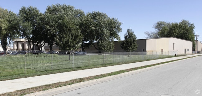

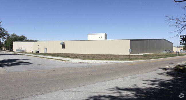
Property Detail
601 Dryer Rd
Omaha, NE-IA
WATERLOO OUT LOTS LOT 10 BLOCK 0 IRREG TRT LYING S OF CO RD 29 & N OF LINCOLN AVE & BEING PT TAX LOTS 8 9 & 10 IN N 1/2 NW 1/4 SEC 10 15 10 & ALL LOTS 9 & 10 27.09 AC WATERLOO OUTLOTS
1335-0010-24
Douglas
Lightindustrial
Nebraska
2024
10
2025
27.09 AC
007508
Northwest Omaha
272,916 SF
Omaha/Council Bluffs
NEARBY LISTINGS FOR SALE OR LEASE
DEMOGRAPHICS near 601 Dryer Rd
1 mile
3 mile
5 mile
2025 Total Population
1,006
12,466
46,010
2030 Population
1,054
13,178
48,627
Pop Growth 2025-2030
+ 4.77%
+ 5.71%
+ 5.69%
Average Age
42
39
38
2025 Total Households
407
4,551
16,658
HH Growth 2025-2030
+ 4.91%
+ 5.95%
+ 5.87%
Median Household Inc
$95,895
$118,942
$138,432
Avg Household Size
2.50
2.70
2.70
2025 Avg HH Vehicles
2.00
2.00
2.00
Median Home Value
$319,091
$389,151
$471,720
Median Year Built
1978
2002
2009
Nearby Places
Map Layers
Map Styles
 Street
 Aerial
Layers
 Traffic
 Biking
Places
Listings with unknown addresses are not visible on the map
- Restaurants
- Banks
- Shops
- Fitness
- Groceries
PUBLIC TRANSPORTATION
AIRPORT
Eppley Airfield
Drive
Walk
Distance
Eppley Airfield
43 min
23.7 mi
Freight Ports
Tulsa Port Of Catoosa
Drive
Walk
Distance
Tulsa Port Of Catoosa
492 min
438.4 mi
Nearby Properties
Address
Land Use
TOTAL SIZE
Lot Size
Zoning
Address
Land Use
TOTAL SIZE
Lot Size
Zoning
441,099 SF
114.30 AC
Address
Land Use
TOTAL SIZE
Lot Size
Zoning
241,480 SF
9.54 AC
Address
Land Use
TOTAL SIZE
Lot Size
Zoning
134,188 SF
6.05 AC
Address
Land Use
TOTAL SIZE
Lot Size
Zoning
162,300 SF
17.46 AC
Address
Land Use
TOTAL SIZE
Lot Size
Zoning
144,006 SF
5.86 AC
Address
Land Use
TOTAL SIZE
Lot Size
Zoning
132,938 SF
7.76 AC
Address
Land Use
TOTAL SIZE
Lot Size
Zoning
106,857 SF
4.97 AC
Address
Land Use
TOTAL SIZE
Lot Size
Zoning
114,371 SF
3.12 AC
Address
Land Use
TOTAL SIZE
Lot Size
Zoning
117,761 SF
3.45 AC
Address
Land Use
TOTAL SIZE
Lot Size
Zoning
43,266 SF
2.01 AC
GC
Address
Land Use
TOTAL SIZE
Lot Size
Zoning
109,698 SF
4.35 AC
CC
Address
Land Use
TOTAL SIZE
Lot Size
Zoning
121,076 SF
9.07 AC
Address
Land Use
TOTAL SIZE
Lot Size
Zoning
64,948 SF
4.87 AC
CC
Address
Land Use
TOTAL SIZE
Lot Size
Zoning
61,850 SF
1.31 AC
Address
Land Use
TOTAL SIZE
Lot Size
Zoning
83,958 SF
2.22 AC
Address
Land Use
TOTAL SIZE
Lot Size
Zoning
53,294 SF
3.27 AC
Address
Land Use
TOTAL SIZE
Lot Size
Zoning
53,864 SF
12.56 AC
Address
Land Use
TOTAL SIZE
Lot Size
Zoning
48,350 SF
3.08 AC
R6
Address
Land Use
TOTAL SIZE
Lot Size
Zoning
44,304 SF
4.21 AC
Address
Land Use
TOTAL SIZE
Lot Size
Zoning
86,480 SF
5.76 AC
Address
Land Use
TOTAL SIZE
Lot Size
Zoning
73,505 SF
4.09 AC
Address
Land Use
TOTAL SIZE
Lot Size
Zoning
87,298 SF
6.17 AC
Address
Land Use
TOTAL SIZE
Lot Size
Zoning
42,612 SF
3.99 AC
ELKHORN
Address
Land Use
TOTAL SIZE
Lot Size
Zoning
5,448 SF
1.14 AC
CC
Address
Land Use
TOTAL SIZE
Lot Size
Zoning
30,080 SF
4.06 AC
ELKHORN
Address
Land Use
TOTAL SIZE
Lot Size
Zoning
29,464 SF
2.75 AC
ELKHORN
Address
Land Use
TOTAL SIZE
Lot Size
Zoning
45,528 SF
206 AC
Address
Land Use
TOTAL SIZE
Lot Size
Zoning
32,665 SF
9.63 AC
Address
Land Use
TOTAL SIZE
Lot Size
Zoning
6,480 SF
1.06 AC
CC
The World's #1 Commercial Real Estate Marketplace
Connect with us
© 2026 CoStar Group
The information above has been obtained from sources believed reliable. While we do not doubt its accuracy we have not verified it and make no guarantee, warranty or representation about it. It is your responsibility to independently confirm its accuracy and completeness. Any projections, opinions, assumptions, or estimates used are for example only and do not represent the current or future performance of the property. The value of this transaction to you depends on tax and other factors which should be evaluated by your tax, financial, and legal advisors. You and your advisors should conduct a careful, independent investigation of the property to determine to your satisfaction the suitability of the property for your needs.