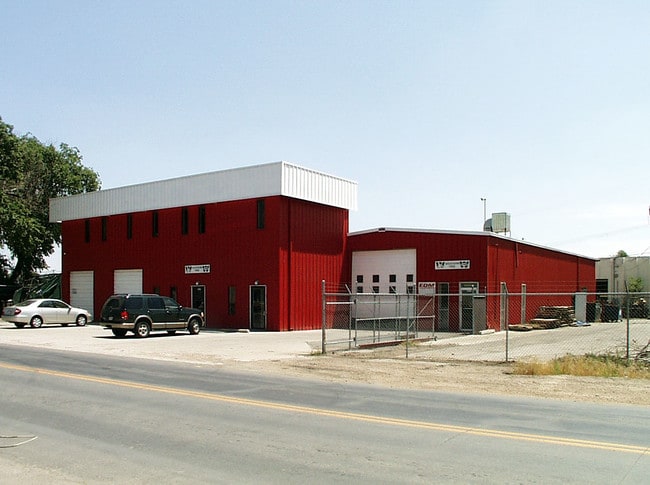
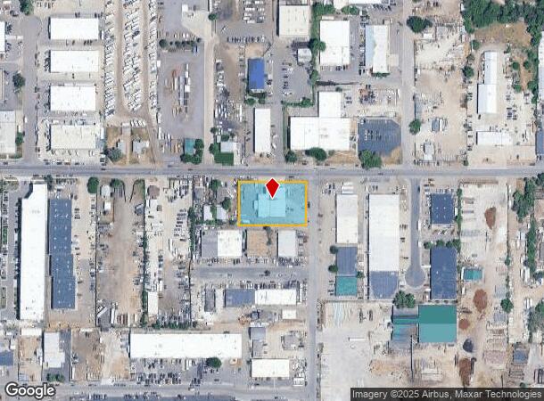
Property Record
6010 W 56Th Ave, Arvada, CO 80002
NEARBY LISTINGS FOR SALE OR LEASE
Property Detail
6010 W 56Th Ave
Denver-Aurora-Centennial, CO
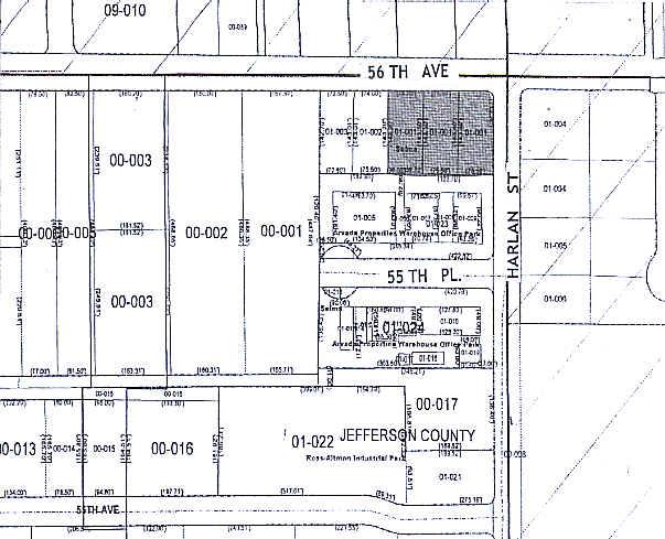
Selma
39-132-01-001
SECTION 13 TOWNSHIP 03 RANGE 69 QTR NW SUBDIVISIONCD 661800 SUBDIVISIONNAME SELMA BLOCK LOT 0001 SIZE: 10168 TRACT VALUE: .233 SECTION 13 TOWNSHIP 03 RANGE 69 SUBDIVISIONCD 661800 SUBDIVISIONNAME SELMA BLOCK LOT 0002 SIZE: 10875 TRACT VALUE: .250 SEC
Industrialgeneral
Jefferson
X
Colorado
08059C0212F
1-3
2023
0.73 AC
2024
Northwest Denver
010406
Denver
10,332 SF
DEMOGRAPHICS near 6010 W 56Th Ave
1 Mile
3 Mile
5 Mile
2024 Total Population
10,096
132,754
378,556
2029 Population
10,051
133,298
383,111
Pop Growth 2024-2029
(0.45%)
+ 0.41%
+ 1.20%
Average Age
38
40
39
2024 Total Households
4,189
56,312
164,781
HH Growth 2024-2029
(0.69%)
+ 0.27%
+ 1.19%
Median Household Inc
$59,897
$81,288
$82,059
Avg Household Size
2.30
2.30
2.20
2024 Avg HH Vehicles
2.00
2.00
2.00
Median Home Value
$418,737
$493,471
$500,908
Median Year Built
1970
1967
1974
Nearby Places
Map Layers
Map Styles
 Street
 Aerial
- Restaurants
- Banks
- Shops
- Fitness
- Groceries
PUBLIC TRANSPORTATION
COMMUTER RAIL
DRIVE
WALK
Distance
3 min
19 min
1.0 mi
DRIVE
WALK
Distance
4 min
20 min
1.0 mi
AIRPORT
Denver International
DRIVE
WALK
Distance
Denver International
37 min
28.1 mi
Nearby Properties
Address
Land Use
TOTAL SIZE
Lot Size
Zoning
Address
Land Use
TOTAL SIZE
Lot Size
Zoning
860,132 SF
68.50 AC
R-5
Address
Land Use
TOTAL SIZE
Lot Size
Zoning
398,180 SF
33.31 AC
R1C
Address
Land Use
TOTAL SIZE
Lot Size
Zoning
470,539 SF
23.59 AC
Address
Land Use
TOTAL SIZE
Lot Size
Zoning
111,673 SF
29.06 AC
Address
Land Use
TOTAL SIZE
Lot Size
Zoning
390,764 SF
20.19 AC
Address
Land Use
TOTAL SIZE
Lot Size
Zoning
298,150 SF
24.21 AC
Address
Land Use
TOTAL SIZE
Lot Size
Zoning
283,572 SF
17.76 AC
Address
Land Use
TOTAL SIZE
Lot Size
Zoning
6,731 SF
80.77 AC
Address
Land Use
TOTAL SIZE
Lot Size
Zoning
436,238 SF
13.94 AC
Address
Land Use
TOTAL SIZE
Lot Size
Zoning
310,267 SF
1.69 AC
C-MX
Address
Land Use
TOTAL SIZE
Lot Size
Zoning
389,561 SF
10.73 AC
Address
Land Use
TOTAL SIZE
Lot Size
Zoning
142,635 SF
6.84 AC
U-SU-B1
Address
Land Use
TOTAL SIZE
Lot Size
Zoning
262,699 SF
13.10 AC
A2
Address
Land Use
TOTAL SIZE
Lot Size
Zoning
76,078 SF
6.64 AC
U-SU-C
Address
Land Use
TOTAL SIZE
Lot Size
Zoning
87,567 SF
14.98 AC
R-5
Address
Land Use
TOTAL SIZE
Lot Size
Zoning
115,719 SF
5.93 AC
Address
Land Use
TOTAL SIZE
Lot Size
Zoning
157,724 SF
10.07 AC
Address
Land Use
TOTAL SIZE
Lot Size
Zoning
149,115 SF
18 AC
Address
Land Use
TOTAL SIZE
Lot Size
Zoning
83,675 SF
13.43 AC
R2
Address
Land Use
TOTAL SIZE
Lot Size
Zoning
163,361 SF
17.09 AC
Address
Land Use
TOTAL SIZE
Lot Size
Zoning
91,734 SF
9.69 AC
Address
Land Use
TOTAL SIZE
Lot Size
Zoning
73,269 SF
3.72 AC
U-SU-B1
Address
Land Use
TOTAL SIZE
Lot Size
Zoning
307,377 SF
15.12 AC
Address
Land Use
TOTAL SIZE
Lot Size
Zoning
144,325 SF
13.22 AC
Address
Land Use
TOTAL SIZE
Lot Size
Zoning
114,348 SF
3 AC
Address
Land Use
TOTAL SIZE
Lot Size
Zoning
139,913 SF
2.87 AC
Address
Land Use
TOTAL SIZE
Lot Size
Zoning
113,903 SF
12.25 AC
Address
Land Use
TOTAL SIZE
Lot Size
Zoning
121,389 SF
3.58 AC
Address
Land Use
TOTAL SIZE
Lot Size
Zoning
177,075 SF
8.71 AC
Address
Land Use
TOTAL SIZE
Lot Size
Zoning
474,246 SF
10.89 AC
B-3
The World's #1 Commercial Real Estate Marketplace
Connect with us
© 2026 CoStar Group
The information above has been obtained from sources believed reliable. While we do not doubt its accuracy we have not verified it and make no guarantee, warranty or representation about it. It is your responsibility to independently confirm its accuracy and completeness. Any projections, opinions, assumptions, or estimates used are for example only and do not represent the current or future performance of the property. The value of this transaction to you depends on tax and other factors which should be evaluated by your tax, financial, and legal advisors. You and your advisors should conduct a careful, independent investigation of the property to determine to your satisfaction the suitability of the property for your needs.