Property Record
6011 31St St E, Bradenton, FL 34203
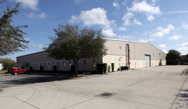

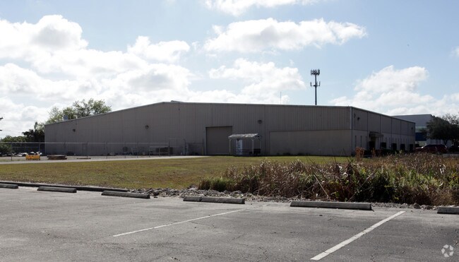

Property Detail
6011 31St St E
18758-1087-9
LOT 17 LESS THE SLY 18 FT THEREOF, HENSON INDUSTRIAL PARK PI#18758.1087/9
Warehouse
Manatee
LM LIGHT M
Florida
B and X Area of moderate flood hazard, usually the area between the limits of the 100-year and 500-year floods.
17
2024
1.31 AC
2025
Manatee
000805
Tampa/St Petersburg
34,168 SF
North Port-Bradenton-Sarasota, FL
NEARBY LISTINGS FOR SALE OR LEASE
DEMOGRAPHICS near 6011 31St St E
1 mile
3 mile
5 mile
2025 Total Population
5,447
73,445
201,394
2030 Population
6,066
81,756
223,197
Pop Growth 2025-2030
+ 11.36%
+ 11.32%
+ 10.83%
Average Age
46
47
45
2025 Total Households
2,187
31,084
86,402
HH Growth 2025-2030
+ 11.57%
+ 11.72%
+ 11.11%
Median Household Inc
$76,460
$68,222
$63,585
Avg Household Size
2.40
2.30
2.20
2025 Avg HH Vehicles
2.00
2.00
2.00
Median Home Value
$406,346
$349,954
$336,949
Median Year Built
1999
1990
1986
Nearby Places
Map Layers
Map Styles
 Street
 Aerial
Layers
 Traffic
 Biking
Places
Listings with unknown addresses are not visible on the map
- Restaurants
- Banks
- Shops
- Fitness
- Groceries
PUBLIC TRANSPORTATION
AIRPORT
Sarasota/Bradenton International
Drive
Walk
Distance
Sarasota/Bradenton International
12 min
6.0 mi
St Pete-Clearwater International
Drive
Walk
Distance
St Pete-Clearwater International
62 min
41.9 mi
Nearby Properties
Address
Land Use
TOTAL SIZE
Lot Size
Zoning
Address
Land Use
TOTAL SIZE
Lot Size
Zoning
1,023,770 SF
76.55 AC
Address
Land Use
TOTAL SIZE
Lot Size
Zoning
425,298 SF
25.59 AC
PD-R
Address
Land Use
TOTAL SIZE
Lot Size
Zoning
385,610 SF
32.65 AC
RMF-6 MULT
Address
Land Use
TOTAL SIZE
Lot Size
Zoning
331,241 SF
44.24 AC
Address
Land Use
TOTAL SIZE
Lot Size
Zoning
241,504 SF
27.72 AC
A GENERAL
Address
Land Use
TOTAL SIZE
Lot Size
Zoning
296,343 SF
26.53 AC
PD-R
Address
Land Use
TOTAL SIZE
Lot Size
Zoning
264,317 SF
9.55 AC
PD-MU
Address
Land Use
TOTAL SIZE
Lot Size
Zoning
294,609 SF
19.15 AC
RMF9
Address
Land Use
TOTAL SIZE
Lot Size
Zoning
375,171 SF
20 AC
PD-MU
Address
Land Use
TOTAL SIZE
Lot Size
Zoning
238,774 SF
15.56 AC
A-1 SUBURB
Address
Land Use
TOTAL SIZE
Lot Size
Zoning
115,400 SF
22.55 AC
LM LIGHT M
Address
Land Use
TOTAL SIZE
Lot Size
Zoning
359,950 SF
34.91 AC
LM LIGHT M
Address
Land Use
TOTAL SIZE
Lot Size
Zoning
187,000 SF
8.93 AC
Address
Land Use
TOTAL SIZE
Lot Size
Zoning
179,670 SF
3.51 AC
LM LIGHT M
Address
Land Use
TOTAL SIZE
Lot Size
Zoning
214,350 SF
16.07 AC
LM LIGHT M
Address
Land Use
TOTAL SIZE
Lot Size
Zoning
296,983 SF
34.84 AC
PD-MU
Address
Land Use
TOTAL SIZE
Lot Size
Zoning
163,394 SF
15.49 AC
PD-MU
Address
Land Use
TOTAL SIZE
Lot Size
Zoning
318,009 SF
34.60 AC
LM LIGHT M
Address
Land Use
TOTAL SIZE
Lot Size
Zoning
901,196 SF
48.54 AC
LM LIGHT M
Address
Land Use
TOTAL SIZE
Lot Size
Zoning
271,970 SF
31.11 AC
PD-I
Address
Land Use
TOTAL SIZE
Lot Size
Zoning
145,200 SF
8.66 AC
Address
Land Use
TOTAL SIZE
Lot Size
Zoning
126,505 SF
20 AC
RSF-2
Address
Land Use
TOTAL SIZE
Lot Size
Zoning
419,956 SF
18.46 AC
LM LIGHT M
Address
Land Use
TOTAL SIZE
Lot Size
Zoning
145,200 SF
8.99 AC
Address
Land Use
TOTAL SIZE
Lot Size
Zoning
10,389 SF
57.58 AC
PD-RV
Address
Land Use
TOTAL SIZE
Lot Size
Zoning
124,129 SF
23.29 AC
PDC
Address
Land Use
TOTAL SIZE
Lot Size
Zoning
143,582 SF
14.42 AC
LM LIGHT M
Address
Land Use
TOTAL SIZE
Lot Size
Zoning
231,364 SF
27.50 AC
PD-PI
Address
Land Use
TOTAL SIZE
Lot Size
Zoning
310,215 SF
134.06 AC
A GENERAL
Address
Land Use
TOTAL SIZE
Lot Size
Zoning
204,309 SF
7.39 AC
PD-I
The World's #1 Commercial Real Estate Marketplace
Connect with us
© 2026 CoStar Group
The information above has been obtained from sources believed reliable. While we do not doubt its accuracy we have not verified it and make no guarantee, warranty or representation about it. It is your responsibility to independently confirm its accuracy and completeness. Any projections, opinions, assumptions, or estimates used are for example only and do not represent the current or future performance of the property. The value of this transaction to you depends on tax and other factors which should be evaluated by your tax, financial, and legal advisors. You and your advisors should conduct a careful, independent investigation of the property to determine to your satisfaction the suitability of the property for your needs.