Property Record
6012 S College Ave, Fort Collins, CO 80525
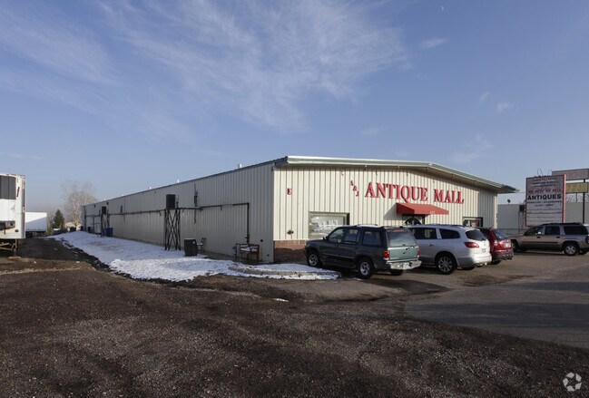

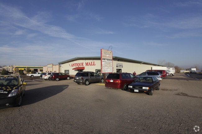
Property Detail
6012 S College Ave
96122-05-023
LOT 23, PLUS THE S 1/2 OF LOT 24 KELMAR STRIP 2ND, FTC
Commercialbuilding
Larimer
C
Colorado
B and X Area of moderate flood hazard, usually the area between the limits of the 100-year and 500-year floods.
23,24
2024
1.17 AC
2025
Fort Collins/Loveland
001009
Denver
12,960 SF
Fort Collins-Loveland, CO
NEARBY LISTINGS FOR SALE OR LEASE
DEMOGRAPHICS near 6012 S College Ave
1 mile
3 mile
5 mile
2025 Total Population
6,915
56,782
150,369
2030 Population
7,143
58,422
155,283
Pop Growth 2025-2030
+ 3.30%
+ 2.89%
+ 3.27%
Average Age
40
40
38
2025 Total Households
2,617
23,228
60,693
HH Growth 2025-2030
+ 3.48%
+ 3.10%
+ 3.69%
Median Household Inc
$119,245
$103,154
$89,512
Avg Household Size
2.60
2.40
2.30
2025 Avg HH Vehicles
2.00
2.00
2.00
Median Home Value
$606,054
$646,776
$614,397
Median Year Built
1996
1995
1994
Nearby Places
Map Layers
Map Styles
 Street
 Aerial
Layers
 Traffic
 Biking
Places
Listings with unknown addresses are not visible on the map
- Restaurants
- Banks
- Shops
- Fitness
- Groceries
Nearby Properties
Address
Land Use
TOTAL SIZE
Lot Size
Zoning
Address
Land Use
TOTAL SIZE
Lot Size
Zoning
235,094 SF
20.06 AC
HC
Address
Land Use
TOTAL SIZE
Lot Size
Zoning
215,240 SF
29.22 AC
RL
Address
Land Use
TOTAL SIZE
Lot Size
Zoning
222,592 SF
21.69 AC
HC
Address
Land Use
TOTAL SIZE
Lot Size
Zoning
137,014 SF
13.64 AC
HC
Address
Land Use
TOTAL SIZE
Lot Size
Zoning
337,566 SF
2.62 AC
Address
Land Use
TOTAL SIZE
Lot Size
Zoning
173,575 SF
28.86 AC
RL
Address
Land Use
TOTAL SIZE
Lot Size
Zoning
1,440 SF
120.01 AC
I1
Address
Land Use
TOTAL SIZE
Lot Size
Zoning
115,260 SF
9.08 AC
HC
Address
Land Use
TOTAL SIZE
Lot Size
Zoning
181,956 SF
5 AC
C
Address
Land Use
TOTAL SIZE
Lot Size
Zoning
42,205 SF
11.50 AC
Address
Land Use
TOTAL SIZE
Lot Size
Zoning
67,144 SF
39.41 AC
Address
Land Use
TOTAL SIZE
Lot Size
Zoning
109,911 SF
6.74 AC
Address
Land Use
TOTAL SIZE
Lot Size
Zoning
263,320 SF
9.39 AC
Address
Land Use
TOTAL SIZE
Lot Size
Zoning
363,533 SF
13.39 AC
Address
Land Use
TOTAL SIZE
Lot Size
Zoning
117,157 SF
117.61 AC
Address
Land Use
TOTAL SIZE
Lot Size
Zoning
112,500 SF
30 AC
RL
Address
Land Use
TOTAL SIZE
Lot Size
Zoning
159,256 SF
8.64 AC
C
Address
Land Use
TOTAL SIZE
Lot Size
Zoning
389,012 SF
16.99 AC
MMN
Address
Land Use
TOTAL SIZE
Lot Size
Zoning
262,972 SF
15.57 AC
LMN
Address
Land Use
TOTAL SIZE
Lot Size
Zoning
38,592 SF
20.06 AC
HC
Address
Land Use
TOTAL SIZE
Lot Size
Zoning
93,138 SF
14.45 AC
MMN
Address
Land Use
TOTAL SIZE
Lot Size
Zoning
105,514 SF
9.55 AC
HC
Address
Land Use
TOTAL SIZE
Lot Size
Zoning
34,094 SF
Address
Land Use
TOTAL SIZE
Lot Size
Zoning
75,197 SF
6.51 AC
C
Address
Land Use
TOTAL SIZE
Lot Size
Zoning
322,880 SF
12.40 AC
HC
Address
Land Use
TOTAL SIZE
Lot Size
Zoning
61,604 SF
9.39 AC
Address
Land Use
TOTAL SIZE
Lot Size
Zoning
55,831 SF
6.69 AC
Address
Land Use
TOTAL SIZE
Lot Size
Zoning
129,570 SF
11.95 AC
HC
Address
Land Use
TOTAL SIZE
Lot Size
Zoning
117,558 SF
7.96 AC
Address
Land Use
TOTAL SIZE
Lot Size
Zoning
193,385 SF
12.97 AC
MMN
The World's #1 Commercial Real Estate Marketplace
Connect with us
© 2026 CoStar Group
The information above has been obtained from sources believed reliable. While we do not doubt its accuracy we have not verified it and make no guarantee, warranty or representation about it. It is your responsibility to independently confirm its accuracy and completeness. Any projections, opinions, assumptions, or estimates used are for example only and do not represent the current or future performance of the property. The value of this transaction to you depends on tax and other factors which should be evaluated by your tax, financial, and legal advisors. You and your advisors should conduct a careful, independent investigation of the property to determine to your satisfaction the suitability of the property for your needs.