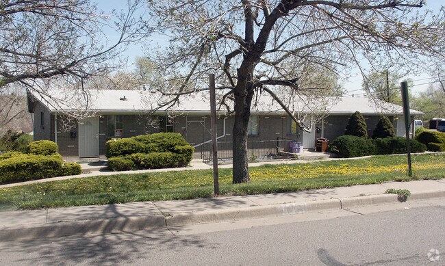
Property Record
602 Wolff St, Denver, CO 80204


NEARBY LISTINGS FOR SALE OR LEASE
-
-
No Photo
-
-
-
-
-
-
-
-
-
-
-
-
-
-
-
View all Denver listings for sale on LoopNet.com
Property Detail
602 Wolff St
Denver-Aurora-Centennial, CO
Kelly James Sub
5066-23-005
L 1 & PT OF L 2 LYG NLY OF A LI EXTDG SELY FR A PT 60FT N OF SW COR SD L TO PT ON ELI 50 FT N OF SE COR & OUTLOT A EXC BEG 50FT N OF SW COR TH S 50FT
Multifamilydwelling
Denver
X
Colorado
0800460181H
1,2
2024
0.31 AC
2024
Villa Park
000904
Denver
2,308 SF
DEMOGRAPHICS near 602 Wolff St
1 Mile
3 Mile
5 Mile
2024 Total Population
23,155
176,427
483,021
2029 Population
23,311
177,115
486,771
Pop Growth 2024-2029
+ 0.67%
+ 0.39%
+ 0.78%
Average Age
37
37
38
2024 Total Households
8,485
73,168
223,768
HH Growth 2024-2029
+ 0.70%
+ 0.46%
+ 0.92%
Median Household Inc
$54,765
$68,167
$79,412
Avg Household Size
2.60
2.30
2.10
2024 Avg HH Vehicles
2.00
2.00
2.00
Median Home Value
$411,765
$476,818
$551,262
Median Year Built
1957
1963
1968
Nearby Places
Map Layers
Map Styles
 Street
 Aerial
- Restaurants
- Banks
- Shops
- Fitness
- Groceries
PUBLIC TRANSPORTATION
TRANSIT/SUBWAY
Sheridan (W Line - Denver Regional Transportation District Light Rail (TheRide))
DRIVE
WALK
Distance
Sheridan (W Line - Denver Regional Transportation District Light Rail (TheRide))
2 min
17 min
0.9 mi
Perry (W Line - Denver Regional Transportation District Light Rail (TheRide))
DRIVE
WALK
Distance
Perry (W Line - Denver Regional Transportation District Light Rail (TheRide))
5 min
19 min
1.0 mi
COMMUTER RAIL
Union Station: Lodo-Coors Field-16Th Street Mall (C Line - Denver Regional Transportation District Light Rail (TheRide), E Line - Denver Regional Transportation District Light Rail (TheRide), W Line - Denver Regional Transportation District Light Rail (TheRide))
DRIVE
WALK
Distance
Union Station: Lodo-Coors Field-16Th Street Mall (C Line - Denver Regional Transportation District Light Rail (TheRide), E Line - Denver Regional Transportation District Light Rail (TheRide), W Line - Denver Regional Transportation District Light Rail (TheRide))
10 min
4.9 mi
Denver (California Zephyr - Amtrak)
DRIVE
WALK
Distance
Denver (California Zephyr - Amtrak)
10 min
5.1 mi
AIRPORT
Denver International
DRIVE
WALK
Distance
Denver International
40 min
29.1 mi
Freight Ports
Tulsa Port Of Catoosa
DRIVE
WALK
Distance
Tulsa Port Of Catoosa
737 min
714.6 mi
SALE & LEASE HISTORY
LISTING DATE
SALE/LEASE

Oct 03, 2017
For Sale
Jul 25, 2017
For Sale
Nearby Properties
Address
Land Use
TOTAL SIZE
Lot Size
Zoning
Address
Land Use
TOTAL SIZE
Lot Size
Zoning
1,721,086 SF
21.34 AC
C-MU-30
Address
Land Use
TOTAL SIZE
Lot Size
Zoning
337,495 SF
0.57 AC
D-C
Address
Land Use
TOTAL SIZE
Lot Size
Zoning
1,078,109 SF
36.79 AC
CMP-EI
Address
Land Use
TOTAL SIZE
Lot Size
Zoning
343,483 SF
5.62 AC
D-TD
Address
Land Use
TOTAL SIZE
Lot Size
Zoning
345,616 SF
3.45 AC
PUD
Address
Land Use
TOTAL SIZE
Lot Size
Zoning
424,862 SF
32.28 AC
G-MU-3
Address
Land Use
TOTAL SIZE
Lot Size
Zoning
729,679 SF
C-MX
Address
Land Use
TOTAL SIZE
Lot Size
Zoning
384,998 SF
2.75 AC
D-TD
Address
Land Use
TOTAL SIZE
Lot Size
Zoning
113,932 SF
9.60 AC
I-B
Address
Land Use
TOTAL SIZE
Lot Size
Zoning
33.40 AC
C-MU-30
Address
Land Use
TOTAL SIZE
Lot Size
Zoning
323,426 SF
29.84 AC
I-B
Address
Land Use
TOTAL SIZE
Lot Size
Zoning
44.93 AC
CPV-C
Address
Land Use
TOTAL SIZE
Lot Size
Zoning
212,252 SF
0.93 AC
D-LD
Address
Land Use
TOTAL SIZE
Lot Size
Zoning
514,899 SF
15.51 AC
CMP-EI
Address
Land Use
TOTAL SIZE
Lot Size
Zoning
168,523 SF
44.89 AC
CPV-R
Address
Land Use
TOTAL SIZE
Lot Size
Zoning
333,925 SF
3.34 AC
C-MX-5
Address
Land Use
TOTAL SIZE
Lot Size
Zoning
159,202 SF
1.03 AC
C-MX-5
Address
Land Use
TOTAL SIZE
Lot Size
Zoning
8,295 SF
2.57 AC
C-RX
Address
Land Use
TOTAL SIZE
Lot Size
Zoning
827,707 SF
19 AC
C-MU-30
Address
Land Use
TOTAL SIZE
Lot Size
Zoning
145,295 SF
1.09 AC
D-C
Address
Land Use
TOTAL SIZE
Lot Size
Zoning
107,351 SF
5.67 AC
C-MX-5
Address
Land Use
TOTAL SIZE
Lot Size
Zoning
144,383 SF
10.26 AC
CMP-EI
Address
Land Use
TOTAL SIZE
Lot Size
Zoning
114,201 SF
0.47 AC
D-LD
Address
Land Use
TOTAL SIZE
Lot Size
Zoning
302,529 SF
1.20 AC
PUD
Address
Land Use
TOTAL SIZE
Lot Size
Zoning
565,418 SF
4.07 AC
C-RX
Address
Land Use
TOTAL SIZE
Lot Size
Zoning
127,933 SF
3.52 AC
CMP-EI
Address
Land Use
TOTAL SIZE
Lot Size
Zoning
282,315 SF
11.41 AC
G-MU-3
Address
Land Use
TOTAL SIZE
Lot Size
Zoning
132,874 SF
6.53 AC
G-MU-3
Address
Land Use
TOTAL SIZE
Lot Size
Zoning
175,000 SF
2.99 AC
C-MX
Address
Land Use
TOTAL SIZE
Lot Size
Zoning
233,688 SF
22.37 AC
The World's #1 Commercial Real Estate Marketplace
Connect with us
© 2026 CoStar Group
The information above has been obtained from sources believed reliable. While we do not doubt its accuracy we have not verified it and make no guarantee, warranty or representation about it. It is your responsibility to independently confirm its accuracy and completeness. Any projections, opinions, assumptions, or estimates used are for example only and do not represent the current or future performance of the property. The value of this transaction to you depends on tax and other factors which should be evaluated by your tax, financial, and legal advisors. You and your advisors should conduct a careful, independent investigation of the property to determine to your satisfaction the suitability of the property for your needs.