Property Record
602 W 20Th St, Merced, CA 95340
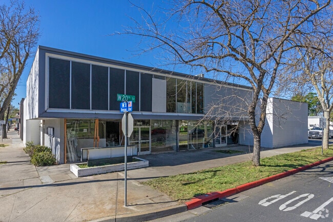


Property Detail
602 W 20Th St
Merced, CA
MERCED N 66 LOTS 1-3 & N 66 SE1/2 LOT 4 BLK 125
031-053-012
Merced
Commercialnec
California
CC
1-3,4
AO River or stream flood hazard areas, and areas with a 1% or greater chance of shallow flooding each year. These areas have a 26% chance of flooding over the life of a 30-year mortgage.
0.27 AC
2024
Suburban Merced
2025
Fresno
001301
NEARBY LISTINGS FOR SALE OR LEASE
-
-
-
-
-
-
-
No Photo
-
View all Merced listings for lease on LoopNet.com
DEMOGRAPHICS near 602 W 20Th St
1 mile
3 mile
5 mile
2025 Total Population
17,381
100,650
117,511
2030 Population
18,011
104,650
122,461
Pop Growth 2025-2030
+ 3.62%
+ 3.97%
+ 4.21%
Average Age
36
35
35
2025 Total Households
6,109
31,223
35,827
HH Growth 2025-2030
+ 3.80%
+ 3.98%
+ 4.19%
Median Household Inc
$37,248
$53,543
$56,345
Avg Household Size
2.70
3.10
3.10
2025 Avg HH Vehicles
1.00
2.00
2.00
Median Home Value
$329,794
$366,968
$376,468
Median Year Built
1964
1982
1985
Nearby Places
Map Layers
Map Styles
 Street
 Aerial
Transit
 Traffic
 Biking
Places
Listings with unknown addresses are not visible on the map
- Restaurants
- Banks
- Shops
- Fitness
- Groceries
SALE & LEASE HISTORY
LISTING DATE
SALE/LEASE

Sep 25, 2016
For Lease
Sep 23, 2016
For Sale
Mar 11, 2024
For Lease
Feb 28, 2020
For Lease
Feb 13, 2023
For Lease
Feb 08, 2019
For Lease
Dec 20, 2019
For Lease
Nearby Properties
Address
Land Use
TOTAL SIZE
Lot Size
Zoning
Address
Land Use
TOTAL SIZE
Lot Size
Zoning
17.50 AC
CO
Address
Land Use
TOTAL SIZE
Lot Size
Zoning
4.01 AC
Address
Land Use
TOTAL SIZE
Lot Size
Zoning
7,182 SF
14.73 AC
R32
Address
Land Use
TOTAL SIZE
Lot Size
Zoning
7.80 AC
IL
Address
Land Use
TOTAL SIZE
Lot Size
Zoning
12.35 AC
CG
Address
Land Use
TOTAL SIZE
Lot Size
Zoning
10.18 AC
R16
Address
Land Use
TOTAL SIZE
Lot Size
Zoning
4.87 AC
PD
Address
Land Use
TOTAL SIZE
Lot Size
Zoning
2.90 AC
CO
Address
Land Use
TOTAL SIZE
Lot Size
Zoning
27.48 AC
PD
Address
Land Use
TOTAL SIZE
Lot Size
Zoning
3.50 AC
R4
Address
Land Use
TOTAL SIZE
Lot Size
Zoning
8.44 AC
PD
Address
Land Use
TOTAL SIZE
Lot Size
Zoning
10.10 AC
PD
Address
Land Use
TOTAL SIZE
Lot Size
Zoning
18.40 AC
IL
Address
Land Use
TOTAL SIZE
Lot Size
Zoning
11.57 AC
IL
Address
Land Use
TOTAL SIZE
Lot Size
Zoning
28.36 AC
Address
Land Use
TOTAL SIZE
Lot Size
Zoning
15,189 SF
1.70 AC
CO
Address
Land Use
TOTAL SIZE
Lot Size
Zoning
1,416 SF
5.57 AC
R16
Address
Land Use
TOTAL SIZE
Lot Size
Zoning
3.90 AC
PD
Address
Land Use
TOTAL SIZE
Lot Size
Zoning
4.50 AC
R4
Address
Land Use
TOTAL SIZE
Lot Size
Zoning
2 AC
PD
Address
Land Use
TOTAL SIZE
Lot Size
Zoning
10.30 AC
CT
Address
Land Use
TOTAL SIZE
Lot Size
Zoning
11.80 AC
PD
Address
Land Use
TOTAL SIZE
Lot Size
Zoning
5.91 AC
PD
Address
Land Use
TOTAL SIZE
Lot Size
Zoning
0.48 AC
CC
Address
Land Use
TOTAL SIZE
Lot Size
Zoning
124,880 SF
10 AC
PD
Address
Land Use
TOTAL SIZE
Lot Size
Zoning
1.80 AC
Address
Land Use
TOTAL SIZE
Lot Size
Zoning
9,000 SF
9.30 AC
IH
Address
Land Use
TOTAL SIZE
Lot Size
Zoning
21.74 AC
IL
Address
Land Use
TOTAL SIZE
Lot Size
Zoning
1.90 AC
CT
Address
Land Use
TOTAL SIZE
Lot Size
Zoning
6,296 SF
3.30 AC
The World's #1 Commercial Real Estate Marketplace
Connect with us
© 2026 CoStar Group
The information above has been obtained from sources believed reliable. While we do not doubt its accuracy we have not verified it and make no guarantee, warranty or representation about it. It is your responsibility to independently confirm its accuracy and completeness. Any projections, opinions, assumptions, or estimates used are for example only and do not represent the current or future performance of the property. The value of this transaction to you depends on tax and other factors which should be evaluated by your tax, financial, and legal advisors. You and your advisors should conduct a careful, independent investigation of the property to determine to your satisfaction the suitability of the property for your needs.