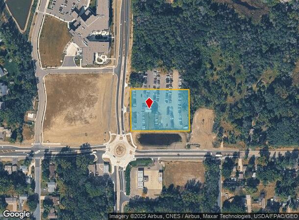
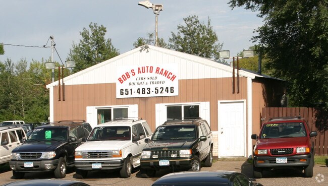
Property Record
6020 Hodgson Rd, Circle Pines, MN 55014

NEARBY LISTINGS FOR SALE OR LEASE
Property Detail
6020 Hodgson Rd
Minneapolis-St. Paul-Bloomington, MN-WI
Auditors Subdivision No 107
31-31-22-44-0009
N 235 FT OF S 367 FT OF W 330 FT OF SE1/4 OF SE1/4 SEC 31 TWP 31 RGE 22 AKA PRT OF LOT 18 AUDITORS SUBDIVISION NO 107
Commercialnec
Anoka
X
Minnesota
27053C0250F
18
2025
1.78 AC
2025
Rosedale
050237
Minneapolis/St Paul
936 SF
DEMOGRAPHICS near 6020 Hodgson Rd
1 Mile
3 Mile
5 Mile
2024 Total Population
4,885
39,636
98,309
2029 Population
4,870
40,169
98,828
Pop Growth 2024-2029
(0.31%)
+ 1.34%
+ 0.53%
Average Age
43
42
41
2024 Total Households
1,876
15,032
37,079
HH Growth 2024-2029
(0.48%)
+ 1.26%
+ 0.23%
Median Household Inc
$124,940
$102,108
$102,047
Avg Household Size
2.60
2.60
2.60
2024 Avg HH Vehicles
2.00
2.00
2.00
Median Home Value
$371,909
$336,198
$341,850
Median Year Built
1986
1985
1984
Nearby Places
Map Layers
Map Styles
 Street
 Aerial
- Restaurants
- Banks
- Shops
- Fitness
- Groceries
PUBLIC TRANSPORTATION
AIRPORT
Minneapolis-St Paul International/Wold-Chamberlain
DRIVE
WALK
Distance
Minneapolis-St Paul International/Wold-Chamberlain
35 min
22.5 mi
Freight Ports
Port Milwaukee
DRIVE
WALK
Distance
Port Milwaukee
380 min
341.5 mi
Nearby Properties
Address
Land Use
TOTAL SIZE
Lot Size
Zoning
Address
Land Use
TOTAL SIZE
Lot Size
Zoning
467.27 AC
Address
Land Use
TOTAL SIZE
Lot Size
Zoning
226,201 SF
70.59 AC
Address
Land Use
TOTAL SIZE
Lot Size
Zoning
223.30 AC
Address
Land Use
TOTAL SIZE
Lot Size
Zoning
264,300 SF
4.16 AC
Address
Land Use
TOTAL SIZE
Lot Size
Zoning
Address
Land Use
TOTAL SIZE
Lot Size
Zoning
260,375 SF
4.24 AC
Address
Land Use
TOTAL SIZE
Lot Size
Zoning
606,798 SF
49.16 AC
Address
Land Use
TOTAL SIZE
Lot Size
Zoning
239,318 SF
Address
Land Use
TOTAL SIZE
Lot Size
Zoning
109.41 AC
Address
Land Use
TOTAL SIZE
Lot Size
Zoning
150,034 SF
48.48 AC
Address
Land Use
TOTAL SIZE
Lot Size
Zoning
129,278 SF
4.53 AC
Address
Land Use
TOTAL SIZE
Lot Size
Zoning
248,816 SF
14.02 AC
Address
Land Use
TOTAL SIZE
Lot Size
Zoning
109,136 SF
Address
Land Use
TOTAL SIZE
Lot Size
Zoning
77,940 SF
19.07 AC
Address
Land Use
TOTAL SIZE
Lot Size
Zoning
235,504 SF
30.54 AC
Address
Land Use
TOTAL SIZE
Lot Size
Zoning
185,498 SF
25.01 AC
Address
Land Use
TOTAL SIZE
Lot Size
Zoning
243,028 SF
24.35 AC
Address
Land Use
TOTAL SIZE
Lot Size
Zoning
61,617 SF
Address
Land Use
TOTAL SIZE
Lot Size
Zoning
134,484 SF
6.69 AC
Address
Land Use
TOTAL SIZE
Lot Size
Zoning
99,056 SF
6.57 AC
Address
Land Use
TOTAL SIZE
Lot Size
Zoning
99,664 SF
6.75 AC
Address
Land Use
TOTAL SIZE
Lot Size
Zoning
109,470 SF
12.67 AC
Address
Land Use
TOTAL SIZE
Lot Size
Zoning
174,573 SF
10.40 AC
Address
Land Use
TOTAL SIZE
Lot Size
Zoning
98,868 SF
12.94 AC
Address
Land Use
TOTAL SIZE
Lot Size
Zoning
69,678 SF
11.17 AC
Address
Land Use
TOTAL SIZE
Lot Size
Zoning
1.25 AC
Address
Land Use
TOTAL SIZE
Lot Size
Zoning
91,880 SF
41.32 AC
Address
Land Use
TOTAL SIZE
Lot Size
Zoning
Address
Land Use
TOTAL SIZE
Lot Size
Zoning
70,653 SF
19.15 AC
Address
Land Use
TOTAL SIZE
Lot Size
Zoning
115.94 AC
The World's #1 Commercial Real Estate Marketplace
Connect with us
© 2025 CoStar Group
The information above has been obtained from sources believed reliable. While we do not doubt its accuracy we have not verified it and make no guarantee, warranty or representation about it. It is your responsibility to independently confirm its accuracy and completeness. Any projections, opinions, assumptions, or estimates used are for example only and do not represent the current or future performance of the property. The value of this transaction to you depends on tax and other factors which should be evaluated by your tax, financial, and legal advisors. You and your advisors should conduct a careful, independent investigation of the property to determine to your satisfaction the suitability of the property for your needs.