Property Record
6025 Cumming Hwy, Sugar Hill, GA 30518


Save to a Folder
{{folder.Name}}
{{folder.ListingIds.length}} Properties
{{folder.ListingIds.length}} Property
Create a New Folder
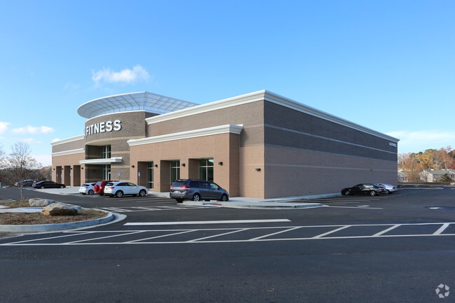
Property Detail
6025 Cumming Hwy
7-347-022
L8 MARKETPLACE AT SUGAR HILL
Gymhealthspa
GWINNETT
BG
Georgia
B and X Area of moderate flood hazard, usually the area between the limits of the 100-year and 500-year floods.
273
2025
7.62 AC
2025
Suwanee/Buford
050120
Atlanta
33,033 SF
Atlanta-Sandy Springs-Roswell, GA
NEARBY LISTINGS FOR SALE OR LEASE
DEMOGRAPHICS near 6025 Cumming Hwy
1 mile
3 mile
5 mile
2025 Total Population
4,957
53,343
139,092
2030 Population
5,156
56,535
148,187
Pop Growth 2025-2030
+ 4.01%
+ 5.98%
+ 6.54%
Average Age
38
38
39
2025 Total Households
1,505
16,829
44,553
HH Growth 2025-2030
+ 4.25%
+ 6.08%
+ 6.63%
Median Household Inc
$134,790
$126,325
$130,139
Avg Household Size
3.20
3.10
3.10
2025 Avg HH Vehicles
2.00
2.00
2.00
Median Home Value
$512,248
$533,515
$585,264
Median Year Built
2004
2002
2002
Nearby Places
Map Layers
Map Styles
 Street
 Aerial
Layers
 Traffic
 Biking
Places
Listings with unknown addresses are not visible on the map
- Restaurants
- Banks
- Shops
- Fitness
- Groceries
PUBLIC TRANSPORTATION
AIRPORT
Hartsfield - Jackson Atlanta International
Drive
Walk
Distance
Hartsfield - Jackson Atlanta International
59 min
47.1 mi
Nearby Properties
Address
Land Use
TOTAL SIZE
Lot Size
Zoning
Address
Land Use
TOTAL SIZE
Lot Size
Zoning
629,478 SF
1.54 AC
BG
Address
Land Use
TOTAL SIZE
Lot Size
Zoning
488,895 SF
7.50 AC
OI
Address
Land Use
TOTAL SIZE
Lot Size
Zoning
424,176 SF
59.62 AC
R3
Address
Land Use
TOTAL SIZE
Lot Size
Zoning
368,594 SF
2 AC
Address
Land Use
TOTAL SIZE
Lot Size
Zoning
384,000 SF
23.08 AC
BG
Address
Land Use
TOTAL SIZE
Lot Size
Zoning
431,273 SF
11.68 AC
BG
Address
Land Use
TOTAL SIZE
Lot Size
Zoning
151,663 SF
42.77 AC
BG
Address
Land Use
TOTAL SIZE
Lot Size
Zoning
447,399 SF
25.71 AC
GCA
Address
Land Use
TOTAL SIZE
Lot Size
Zoning
367,756 SF
12.04 AC
RM
Address
Land Use
TOTAL SIZE
Lot Size
Zoning
113,271 SF
78.32 AC
C2
Address
Land Use
TOTAL SIZE
Lot Size
Zoning
204,436 SF
16.28 AC
BG2
Address
Land Use
TOTAL SIZE
Lot Size
Zoning
244,214 SF
7.50 AC
OI
Address
Land Use
TOTAL SIZE
Lot Size
Zoning
3,232 SF
66.63 AC
OI
Address
Land Use
TOTAL SIZE
Lot Size
Zoning
289,501 SF
91.27 AC
CR1
Address
Land Use
TOTAL SIZE
Lot Size
Zoning
408 SF
217.12 AC
R100
Address
Land Use
TOTAL SIZE
Lot Size
Zoning
119,188 SF
5.28 AC
BG
Address
Land Use
TOTAL SIZE
Lot Size
Zoning
132,721 SF
51.36 AC
OI
Address
Land Use
TOTAL SIZE
Lot Size
Zoning
143,754 SF
2.73 AC
BG
Address
Land Use
TOTAL SIZE
Lot Size
Zoning
231,490 SF
17.55 AC
RM
Address
Land Use
TOTAL SIZE
Lot Size
Zoning
94,574 SF
18.12 AC
RS100
Address
Land Use
TOTAL SIZE
Lot Size
Zoning
186,015 SF
13.72 AC
MP
Address
Land Use
TOTAL SIZE
Lot Size
Zoning
126,080 SF
30 AC
OI
Address
Land Use
TOTAL SIZE
Lot Size
Zoning
115,555 SF
34.65 AC
R100MOD
Address
Land Use
TOTAL SIZE
Lot Size
Zoning
139,222 SF
23.91 AC
RS100
Address
Land Use
TOTAL SIZE
Lot Size
Zoning
3,366 SF
20.07 AC
PUD
Address
Land Use
TOTAL SIZE
Lot Size
Zoning
98,471 SF
10.86 AC
BG
Address
Land Use
TOTAL SIZE
Lot Size
Zoning
248,970 SF
0.78 AC
Address
Land Use
TOTAL SIZE
Lot Size
Zoning
46,791 SF
4.04 AC
BG
Address
Land Use
TOTAL SIZE
Lot Size
Zoning
129,863 SF
9.06 AC
CBD
Address
Land Use
TOTAL SIZE
Lot Size
Zoning
112,432 SF
4.97 AC
CBD
The World's #1 Commercial Real Estate Marketplace
Connect with us
© 2026 CoStar Group
The information above has been obtained from sources believed reliable. While we do not doubt its accuracy we have not verified it and make no guarantee, warranty or representation about it. It is your responsibility to independently confirm its accuracy and completeness. Any projections, opinions, assumptions, or estimates used are for example only and do not represent the current or future performance of the property. The value of this transaction to you depends on tax and other factors which should be evaluated by your tax, financial, and legal advisors. You and your advisors should conduct a careful, independent investigation of the property to determine to your satisfaction the suitability of the property for your needs.