Property Record
604 Main St, Woodland, CA 95695


Save to a Folder
{{folder.Name}}
{{folder.ListingIds.length}} Properties
{{folder.ListingIds.length}} Property
Create a New Folder
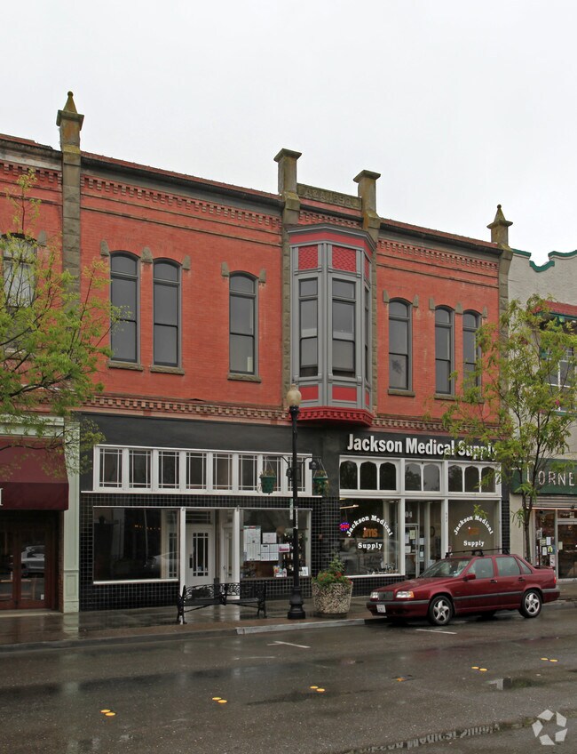
Property Detail
604 Main St
006-563-002-000
SEE LEGAL ON DOC 13-0008688 3-18-2013
Storemultistory
Yolo
C2
California
B and X Area of moderate flood hazard, usually the area between the limits of the 100-year and 500-year floods.
0.13 AC
2024
Woodland
2025
Sacramento
011101
Sacramento-Roseville-Folsom, CA
5,160 SF
NEARBY LISTINGS FOR SALE OR LEASE
DEMOGRAPHICS near 604 Main St
1 mile
3 mile
5 mile
2025 Total Population
20,191
61,999
64,628
2030 Population
20,455
63,007
65,619
Pop Growth 2025-2030
+ 1.31%
+ 1.63%
+ 1.53%
Average Age
39
39
39
2025 Total Households
6,954
21,076
21,957
HH Growth 2025-2030
+ 1.32%
+ 1.71%
+ 1.61%
Median Household Inc
$74,254
$94,513
$95,551
Avg Household Size
2.70
2.80
2.80
2025 Avg HH Vehicles
2.00
2.00
2.00
Median Home Value
$464,478
$552,583
$566,376
Median Year Built
1964
1980
1980
Nearby Places
Map Layers
Map Styles
 Street
 Aerial
Layers
 Traffic
 Biking
Places
Listings with unknown addresses are not visible on the map
- Restaurants
- Banks
- Shops
- Fitness
- Groceries
PUBLIC TRANSPORTATION
AIRPORT
Sacramento International
Drive
Walk
Distance
Sacramento International
19 min
11.8 mi
Nearby Properties
Address
Land Use
TOTAL SIZE
Lot Size
Zoning
Address
Land Use
TOTAL SIZE
Lot Size
Zoning
1,835,779 SF
98.96 AC
I
Address
Land Use
TOTAL SIZE
Lot Size
Zoning
23.92 AC
M2
Address
Land Use
TOTAL SIZE
Lot Size
Zoning
112.50 AC
A1
Address
Land Use
TOTAL SIZE
Lot Size
Zoning
180,816 SF
0.17 AC
R-M
Address
Land Use
TOTAL SIZE
Lot Size
Zoning
12,032 SF
0.12 AC
R3
Address
Land Use
TOTAL SIZE
Lot Size
Zoning
154,682 SF
15.17 AC
CH
Address
Land Use
TOTAL SIZE
Lot Size
Zoning
125,330 SF
10.06 AC
CH
Address
Land Use
TOTAL SIZE
Lot Size
Zoning
515,886 SF
71.53 AC
I
Address
Land Use
TOTAL SIZE
Lot Size
Zoning
348,386 SF
17.67 AC
RM
Address
Land Use
TOTAL SIZE
Lot Size
Zoning
150,269 SF
6.95 AC
R-M
Address
Land Use
TOTAL SIZE
Lot Size
Zoning
9.89 AC
M1
Address
Land Use
TOTAL SIZE
Lot Size
Zoning
87.49 AC
A1
Address
Land Use
TOTAL SIZE
Lot Size
Zoning
247,572 SF
17.04 AC
I
Address
Land Use
TOTAL SIZE
Lot Size
Zoning
400,450 SF
23.16 AC
I
Address
Land Use
TOTAL SIZE
Lot Size
Zoning
8.83 AC
A1
Address
Land Use
TOTAL SIZE
Lot Size
Zoning
38.27 AC
I
Address
Land Use
TOTAL SIZE
Lot Size
Zoning
67,104 SF
0.32 AC
R25
Address
Land Use
TOTAL SIZE
Lot Size
Zoning
260,400 SF
12.30 AC
I
Address
Land Use
TOTAL SIZE
Lot Size
Zoning
83,280 SF
0.22 AC
R-M
Address
Land Use
TOTAL SIZE
Lot Size
Zoning
260,400 SF
12.79 AC
I
Address
Land Use
TOTAL SIZE
Lot Size
Zoning
4.46 AC
C-3
Address
Land Use
TOTAL SIZE
Lot Size
Zoning
356,360 SF
26.50 AC
M2
Address
Land Use
TOTAL SIZE
Lot Size
Zoning
324,475 SF
22.49 AC
I
Address
Land Use
TOTAL SIZE
Lot Size
Zoning
427,073 SF
24.51 AC
I
Address
Land Use
TOTAL SIZE
Lot Size
Zoning
145,694 SF
9.26 AC
MDR20
Address
Land Use
TOTAL SIZE
Lot Size
Zoning
401,500 SF
19.12 AC
I
Address
Land Use
TOTAL SIZE
Lot Size
Zoning
140,000 SF
13.63 AC
I
Address
Land Use
TOTAL SIZE
Lot Size
Zoning
24,500 SF
7.42 AC
EOZ
Address
Land Use
TOTAL SIZE
Lot Size
Zoning
26.48 AC
A1
Address
Land Use
TOTAL SIZE
Lot Size
Zoning
0.16 AC
PUD
The World's #1 Commercial Real Estate Marketplace
Connect with us
© 2026 CoStar Group
The information above has been obtained from sources believed reliable. While we do not doubt its accuracy we have not verified it and make no guarantee, warranty or representation about it. It is your responsibility to independently confirm its accuracy and completeness. Any projections, opinions, assumptions, or estimates used are for example only and do not represent the current or future performance of the property. The value of this transaction to you depends on tax and other factors which should be evaluated by your tax, financial, and legal advisors. You and your advisors should conduct a careful, independent investigation of the property to determine to your satisfaction the suitability of the property for your needs.