Property Record
622 Se 82Nd Ave, Portland, OR 97216
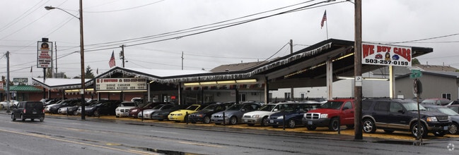

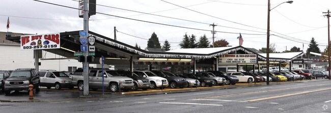
Property Detail
622 Se 82Nd Ave
R281398
SUNRISE PK, BLOCK 2, LOT 1&2 EXC PT IN STS, LOT 3&4, LOT 27-33, LOT 34 EXC PT IN ST
Commercialnec
Multnomah
CG
Oregon
B and X Area of moderate flood hazard, usually the area between the limits of the 100-year and 500-year floods.
1
2025
0.63 AC
2025
Mall 205
001602
Portland
2,074 SF
Portland-Vancouver-Hillsboro, OR-WA
NEARBY LISTINGS FOR SALE OR LEASE
DEMOGRAPHICS near 622 Se 82Nd Ave
1 mile
3 mile
5 mile
2025 Total Population
19,730
207,106
458,345
2030 Population
19,388
203,475
452,281
Pop Growth 2025-2030
(1.73%)
(1.75%)
(1.32%)
Average Age
41
41
41
2025 Total Households
8,080
84,018
188,703
HH Growth 2025-2030
(2.07%)
(2.03%)
(1.47%)
Median Household Inc
$88,296
$86,149
$84,323
Avg Household Size
2.30
2.30
2.30
2025 Avg HH Vehicles
2.00
2.00
2.00
Median Home Value
$495,293
$536,612
$549,300
Median Year Built
1953
1956
1963
Nearby Places
Map Layers
Map Styles
 Street
 Aerial
Layers
 Traffic
 Biking
Places
Listings with unknown addresses are not visible on the map
- Restaurants
- Banks
- Shops
- Fitness
- Groceries
PUBLIC TRANSPORTATION
TRANSIT/SUBWAY
Se Main Street (MAX Green Line - Tri-County Metropolitan Transportation District of Oregon Rail (TriMet Rail))
Drive
Walk
Distance
Se Main Street (MAX Green Line - Tri-County Metropolitan Transportation District of Oregon Rail (TriMet Rail))
3 min
20 min
1.1 mi
COMMUTER RAIL
Portland (Amtrak Cascades - Amtrak, Coast Starlight - Amtrak, Empire Builder - Amtrak)
Drive
Walk
Distance
Portland (Amtrak Cascades - Amtrak, Coast Starlight - Amtrak, Empire Builder - Amtrak)
14 min
6.8 mi
AIRPORT
Portland International
Drive
Walk
Distance
Portland International
14 min
7.4 mi
Freight Ports
Port of Portland
Drive
Walk
Distance
Port of Portland
16 min
8.9 mi
Nearby Properties
Address
Land Use
TOTAL SIZE
Lot Size
Zoning
Address
Land Use
TOTAL SIZE
Lot Size
Zoning
1,024 SF
15.92 AC
OS
Address
Land Use
TOTAL SIZE
Lot Size
Zoning
178,785 SF
10.20 AC
R5
Address
Land Use
TOTAL SIZE
Lot Size
Zoning
197,027 SF
28.54 AC
R7H
Address
Land Use
TOTAL SIZE
Lot Size
Zoning
296,039 SF
11.70 AC
R5
Address
Land Use
TOTAL SIZE
Lot Size
Zoning
183,664 SF
8.96 AC
R5
Address
Land Use
TOTAL SIZE
Lot Size
Zoning
280,069 SF
18.31 AC
IR
Address
Land Use
TOTAL SIZE
Lot Size
Zoning
361,549 SF
39.26 AC
IR
Address
Land Use
TOTAL SIZE
Lot Size
Zoning
140,000 SF
14.53 AC
R7
Address
Land Use
TOTAL SIZE
Lot Size
Zoning
250,280 SF
23.86 AC
IR
Address
Land Use
TOTAL SIZE
Lot Size
Zoning
31,878 SF
15.95 AC
IG2
Address
Land Use
TOTAL SIZE
Lot Size
Zoning
54,676 SF
190.32 AC
OS
Address
Land Use
TOTAL SIZE
Lot Size
Zoning
42,839,055 SF
19.25 AC
CI1
Address
Land Use
TOTAL SIZE
Lot Size
Zoning
152,575 SF
5.32 AC
EG1
Address
Land Use
TOTAL SIZE
Lot Size
Zoning
317,656 SF
21.94 AC
CX
Address
Land Use
TOTAL SIZE
Lot Size
Zoning
64,673 SF
NULL
Address
Land Use
TOTAL SIZE
Lot Size
Zoning
100,217 SF
1.99 AC
R5
Address
Land Use
TOTAL SIZE
Lot Size
Zoning
181,493 SF
3.70 AC
CM1
Address
Land Use
TOTAL SIZE
Lot Size
Zoning
258,082 SF
2.80 AC
CS
Address
Land Use
TOTAL SIZE
Lot Size
Zoning
205,034 SF
0.38 AC
RM1
Address
Land Use
TOTAL SIZE
Lot Size
Zoning
361,241 SF
1.80 AC
CI2
Address
Land Use
TOTAL SIZE
Lot Size
Zoning
101,812 SF
3.14 AC
R5
Address
Land Use
TOTAL SIZE
Lot Size
Zoning
185,799 SF
15.44 AC
CG
Address
Land Use
TOTAL SIZE
Lot Size
Zoning
230,105 SF
3.08 AC
CI2
Address
Land Use
TOTAL SIZE
Lot Size
Zoning
369,835 SF
6.67 AC
IRD
Address
Land Use
TOTAL SIZE
Lot Size
Zoning
99,100 SF
1.31 AC
CS
Address
Land Use
TOTAL SIZE
Lot Size
Zoning
21,200 SF
16.03 AC
OS
Address
Land Use
TOTAL SIZE
Lot Size
Zoning
53,774 SF
3 AC
Address
Land Use
TOTAL SIZE
Lot Size
Zoning
105,961 SF
8.76 AC
RM1
Address
Land Use
TOTAL SIZE
Lot Size
Zoning
126,776 SF
5.07 AC
RH
Address
Land Use
TOTAL SIZE
Lot Size
Zoning
46,879 SF
5.63 AC
CI1
The World's #1 Commercial Real Estate Marketplace
Connect with us
© 2026 CoStar Group
The information above has been obtained from sources believed reliable. While we do not doubt its accuracy we have not verified it and make no guarantee, warranty or representation about it. It is your responsibility to independently confirm its accuracy and completeness. Any projections, opinions, assumptions, or estimates used are for example only and do not represent the current or future performance of the property. The value of this transaction to you depends on tax and other factors which should be evaluated by your tax, financial, and legal advisors. You and your advisors should conduct a careful, independent investigation of the property to determine to your satisfaction the suitability of the property for your needs.