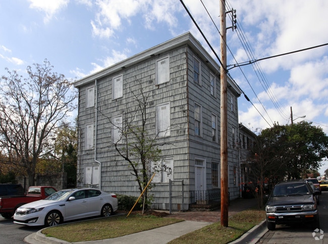
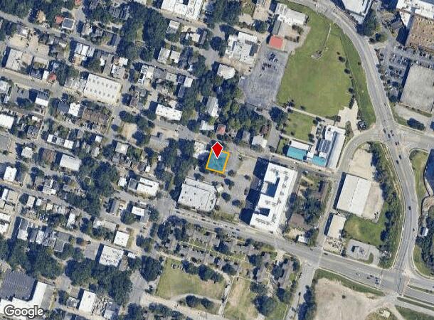
Property Record
611 E Broughton St, Savannah, GA 31401

NEARBY LISTINGS FOR SALE OR LEASE
Property Detail
611 E Broughton St
Savannah, GA
Bee To Skid Apt
2000518006
EASTERN PORTION OF LOTS 2 & 3 CARPENTERS ROW PRB 28P 34 .173AC
Multifamilydwelling
Chatham
X
Georgia
45053C0550D
2
2024
0.17 AC
2025
Greater Savannah
011700
Savannah
6,340 SF
DEMOGRAPHICS near 611 E Broughton St
1 Mile
3 Mile
5 Mile
2024 Total Population
10,081
71,209
114,096
2029 Population
10,766
74,745
119,230
Pop Growth 2024-2029
+ 6.79%
+ 4.97%
+ 4.50%
Average Age
40
38
38
2024 Total Households
5,238
29,930
46,204
HH Growth 2024-2029
+ 7.25%
+ 5.30%
+ 4.83%
Median Household Inc
$65,554
$48,272
$49,712
Avg Household Size
1.80
2.20
2.20
2024 Avg HH Vehicles
1.00
1.00
1.00
Median Home Value
$525,401
$240,714
$219,693
Median Year Built
1948
1953
1960
Nearby Places
Map Layers
Map Styles
 Street
 Aerial
- Restaurants
- Banks
- Shops
- Fitness
- Groceries
PUBLIC TRANSPORTATION
COMMUTER RAIL
DRIVE
WALK
Distance
10 min
4.4 mi
AIRPORT
Savannah/Hilton Head International
DRIVE
WALK
Distance
Savannah/Hilton Head International
21 min
10.3 mi
Hilton Head
DRIVE
WALK
Distance
Hilton Head
61 min
37.6 mi
Freight Ports
Georgia Ports - Savannah
DRIVE
WALK
Distance
Georgia Ports - Savannah
17 min
7.6 mi
Nearby Properties
Address
Land Use
TOTAL SIZE
Lot Size
Zoning
Address
Land Use
TOTAL SIZE
Lot Size
Zoning
1,400 SF
6.97 AC
D-X
Address
Land Use
TOTAL SIZE
Lot Size
Zoning
22.34 AC
PUDBW
Address
Land Use
TOTAL SIZE
Lot Size
Zoning
453,984 SF
10.42 AC
Address
Land Use
TOTAL SIZE
Lot Size
Zoning
31,396 SF
1.69 AC
BG
Address
Land Use
TOTAL SIZE
Lot Size
Zoning
86,336 SF
1.08 AC
BB
Address
Land Use
TOTAL SIZE
Lot Size
Zoning
354,322 SF
6.30 AC
IH
Address
Land Use
TOTAL SIZE
Lot Size
Zoning
4,930 SF
1.18 AC
I-L
Address
Land Use
TOTAL SIZE
Lot Size
Zoning
421 SF
6.82 AC
PUDBW
Address
Land Use
TOTAL SIZE
Lot Size
Zoning
351,297 SF
2.08 AC
BC1
Address
Land Use
TOTAL SIZE
Lot Size
Zoning
124,080 SF
1.66 AC
BB
Address
Land Use
TOTAL SIZE
Lot Size
Zoning
173,554 SF
0.72 AC
BB
Address
Land Use
TOTAL SIZE
Lot Size
Zoning
108,273 SF
18.20 AC
PUDBC
Address
Land Use
TOTAL SIZE
Lot Size
Zoning
33,000 SF
1.92 AC
I-L
Address
Land Use
TOTAL SIZE
Lot Size
Zoning
199,424 SF
2.49 AC
BN
Address
Land Use
TOTAL SIZE
Lot Size
Zoning
116,928 SF
1.10 AC
BB
Address
Land Use
TOTAL SIZE
Lot Size
Zoning
84,560 SF
0.31 AC
BC1
Address
Land Use
TOTAL SIZE
Lot Size
Zoning
77,610 SF
0.33 AC
BC1
Address
Land Use
TOTAL SIZE
Lot Size
Zoning
245,610 SF
1.10 AC
RIPC
Address
Land Use
TOTAL SIZE
Lot Size
Zoning
92,132 SF
4.92 AC
PUDBW
Address
Land Use
TOTAL SIZE
Lot Size
Zoning
115,069 SF
1.14 AC
BC1
Address
Land Use
TOTAL SIZE
Lot Size
Zoning
1.07 AC
BG
Address
Land Use
TOTAL SIZE
Lot Size
Zoning
9,303 SF
9.84 AC
PUDM
Address
Land Use
TOTAL SIZE
Lot Size
Zoning
120,084 SF
0.48 AC
BC1
Address
Land Use
TOTAL SIZE
Lot Size
Zoning
116,000 SF
0.53 AC
BB
Address
Land Use
TOTAL SIZE
Lot Size
Zoning
400,000 SF
1.12 AC
I-L
Address
Land Use
TOTAL SIZE
Lot Size
Zoning
0.49 AC
BC1
Address
Land Use
TOTAL SIZE
Lot Size
Zoning
9 AC
RMF-2-35
Address
Land Use
TOTAL SIZE
Lot Size
Zoning
7,900 SF
1.98 AC
RIPB1
Address
Land Use
TOTAL SIZE
Lot Size
Zoning
60,911 SF
0.17 AC
BB
Address
Land Use
TOTAL SIZE
Lot Size
Zoning
70,124 SF
0.38 AC
BC1
The World's #1 Commercial Real Estate Marketplace
Connect with us
© 2026 CoStar Group
The information above has been obtained from sources believed reliable. While we do not doubt its accuracy we have not verified it and make no guarantee, warranty or representation about it. It is your responsibility to independently confirm its accuracy and completeness. Any projections, opinions, assumptions, or estimates used are for example only and do not represent the current or future performance of the property. The value of this transaction to you depends on tax and other factors which should be evaluated by your tax, financial, and legal advisors. You and your advisors should conduct a careful, independent investigation of the property to determine to your satisfaction the suitability of the property for your needs.