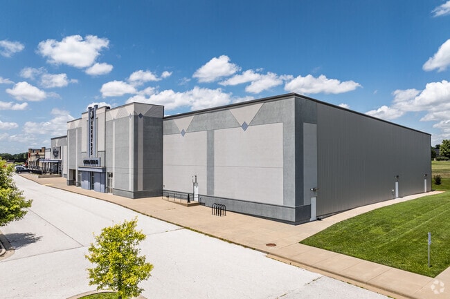
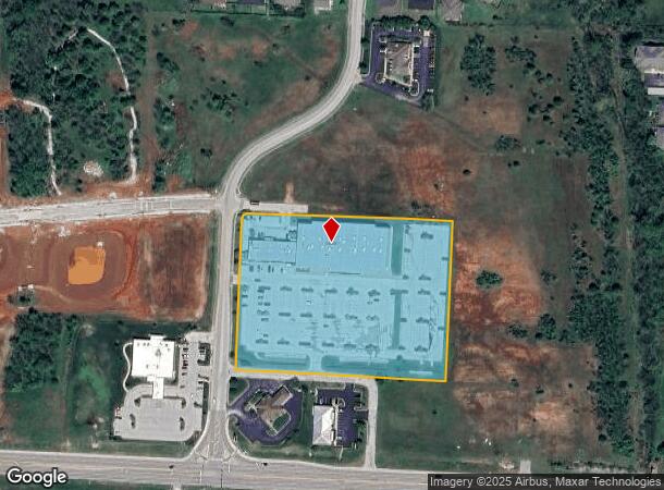
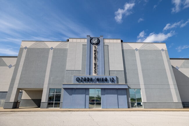
Property Record
612 N 25Th St, Ozark, MO 65721
NEARBY LISTINGS FOR SALE OR LEASE
Property Detail
612 N 25Th St
Springfield, MO
Town & Country Village Ph 1
11-0.5-21-000-000-002.009
LOT 4F THE REPLAT OF LOTS 1 & 2 & LOT 4B OF THE REPLAT LOT 4 OF TOWN & COUNTRY VILLAGE PH 1 ALSO, LOTS 4C1 TOWN & COUNTRY VILLAGE PH 1 REPLAT OF LOT 4C OF THE REPLAT OF LOTS 1 & 2 & REPLAT 4B OF THE REPLAT OF LOT 4
Commercialnec
Christian
X
Missouri
29043C0088D
4f,4b
2023
6.54 AC
2024
West Christian County
020308
Springfield
38,524 SF
DEMOGRAPHICS near 612 N 25Th St
1 Mile
3 Mile
5 Mile
2024 Total Population
2,551
28,561
62,023
2029 Population
2,857
32,306
70,081
Pop Growth 2024-2029
+ 12.00%
+ 13.11%
+ 12.99%
Average Age
36
38
39
2024 Total Households
977
10,487
23,339
HH Growth 2024-2029
+ 12.08%
+ 13.17%
+ 13.06%
Median Household Inc
$78,199
$71,490
$71,529
Avg Household Size
2.60
2.70
2.60
2024 Avg HH Vehicles
2.00
2.00
2.00
Median Home Value
$240,322
$217,290
$222,339
Median Year Built
2000
1998
1998
Nearby Places
Map Layers
Map Styles
 Street
 Aerial
- Restaurants
- Banks
- Shops
- Fitness
- Groceries
PUBLIC TRANSPORTATION
AIRPORT
Springfield-Branson Ntl
DRIVE
WALK
Distance
Springfield-Branson Ntl
42 min
29.6 mi
Freight Ports
Tulsa Port of Inola
DRIVE
WALK
Distance
Tulsa Port of Inola
207 min
184.1 mi
Nearby Properties
Address
Land Use
TOTAL SIZE
Lot Size
Zoning
Address
Land Use
TOTAL SIZE
Lot Size
Zoning
50.60 AC
Address
Land Use
TOTAL SIZE
Lot Size
Zoning
Address
Land Use
TOTAL SIZE
Lot Size
Zoning
66,038 SF
6.24 AC
Address
Land Use
TOTAL SIZE
Lot Size
Zoning
39.87 AC
Address
Land Use
TOTAL SIZE
Lot Size
Zoning
54,830 SF
40 AC
Address
Land Use
TOTAL SIZE
Lot Size
Zoning
48,100 SF
10.57 AC
Address
Land Use
TOTAL SIZE
Lot Size
Zoning
28.40 AC
Address
Land Use
TOTAL SIZE
Lot Size
Zoning
3.07 AC
Address
Land Use
TOTAL SIZE
Lot Size
Zoning
19.78 AC
Address
Land Use
TOTAL SIZE
Lot Size
Zoning
29,340 SF
4.51 AC
Address
Land Use
TOTAL SIZE
Lot Size
Zoning
106,250 SF
8.01 AC
Address
Land Use
TOTAL SIZE
Lot Size
Zoning
27,268 SF
3.51 AC
Address
Land Use
TOTAL SIZE
Lot Size
Zoning
82,000 SF
4.50 AC
Address
Land Use
TOTAL SIZE
Lot Size
Zoning
67,368 SF
7.98 AC
Address
Land Use
TOTAL SIZE
Lot Size
Zoning
21,120 SF
6.68 AC
Address
Land Use
TOTAL SIZE
Lot Size
Zoning
Address
Land Use
TOTAL SIZE
Lot Size
Zoning
24,000 SF
6.46 AC
Address
Land Use
TOTAL SIZE
Lot Size
Zoning
17,626 SF
5.26 AC
Address
Land Use
TOTAL SIZE
Lot Size
Zoning
Address
Land Use
TOTAL SIZE
Lot Size
Zoning
0.54 AC
Address
Land Use
TOTAL SIZE
Lot Size
Zoning
7,920 SF
16.50 AC
Address
Land Use
TOTAL SIZE
Lot Size
Zoning
40,726 SF
4.54 AC
Address
Land Use
TOTAL SIZE
Lot Size
Zoning
11,520 SF
8.62 AC
Address
Land Use
TOTAL SIZE
Lot Size
Zoning
37,520 SF
2.38 AC
Address
Land Use
TOTAL SIZE
Lot Size
Zoning
4,050 SF
4.89 AC
Address
Land Use
TOTAL SIZE
Lot Size
Zoning
75,008 SF
6.12 AC
Address
Land Use
TOTAL SIZE
Lot Size
Zoning
8,512 SF
7.39 AC
Address
Land Use
TOTAL SIZE
Lot Size
Zoning
10,928 SF
3.73 AC
Address
Land Use
TOTAL SIZE
Lot Size
Zoning
7,328 SF
2.81 AC
The World's #1 Commercial Real Estate Marketplace
Connect with us
© 2025 CoStar Group
The information above has been obtained from sources believed reliable. While we do not doubt its accuracy we have not verified it and make no guarantee, warranty or representation about it. It is your responsibility to independently confirm its accuracy and completeness. Any projections, opinions, assumptions, or estimates used are for example only and do not represent the current or future performance of the property. The value of this transaction to you depends on tax and other factors which should be evaluated by your tax, financial, and legal advisors. You and your advisors should conduct a careful, independent investigation of the property to determine to your satisfaction the suitability of the property for your needs.