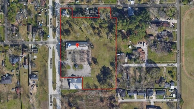
Property Record
6130 Wheatley St, Houston, TX 77091
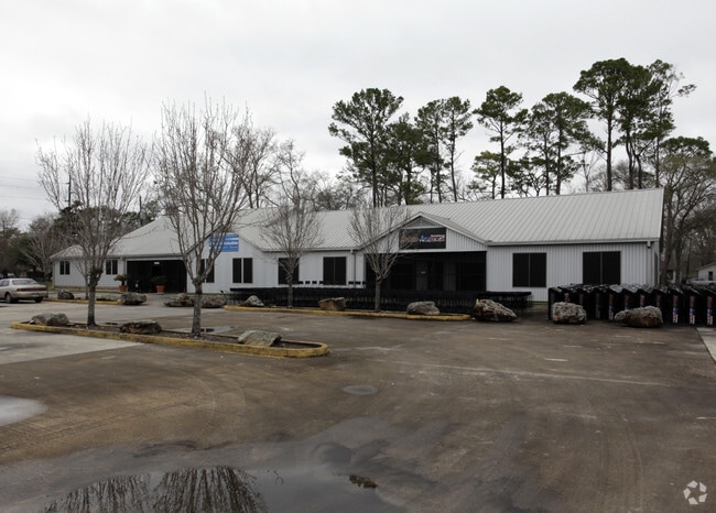

This Property Is For Sale
Property Detail
6130 Wheatley St
Houston-Pasadena-The Woodlands, TX
LT 11 & TRS 10E 10F 12 13 14 15 & E 271 FT OF LT 16 BLK 1A HIGHLAND HEIGHTS
0162780010013
Harris
Storebuilding
Texas
B and X Area of moderate flood hazard, usually the area between the limits of the 100-year and 500-year floods.
11,16
2025
5.68 AC
2025
Near Northwest Oaks
530800
Houston
9,264 SF
NEARBY LISTINGS FOR SALE OR LEASE
DEMOGRAPHICS near 6130 Wheatley St
1 mile
3 mile
5 mile
2025 Total Population
8,729
142,113
388,381
2030 Population
9,571
152,311
415,919
Pop Growth 2025-2030
+ 9.65%
+ 7.18%
+ 7.09%
Average Age
40
37
36
2025 Total Households
3,179
50,794
139,039
HH Growth 2025-2030
+ 9.85%
+ 7.43%
+ 7.45%
Median Household Inc
$37,464
$55,783
$63,010
Avg Household Size
2.60
2.70
2.70
2025 Avg HH Vehicles
2.00
2.00
2.00
Median Home Value
$261,002
$289,685
$295,681
Median Year Built
1977
1974
1977
Nearby Places
Map Layers
Map Styles
 Street
 Aerial
Layers
 Traffic
 Biking
Places
Listings with unknown addresses are not visible on the map
- Restaurants
- Banks
- Shops
- Fitness
- Groceries
PUBLIC TRANSPORTATION
COMMUTER RAIL
Drive
Walk
Distance
16 min
8.8 mi
AIRPORT
George Bush Intcntl/Houston
Drive
Walk
Distance
George Bush Intcntl/Houston
22 min
14.5 mi
William P Hobby
Drive
Walk
Distance
William P Hobby
36 min
21.6 mi
Freight Ports
Port of Houston
Drive
Walk
Distance
Port of Houston
28 min
17.2 mi
Nearby Properties
Address
Land Use
TOTAL SIZE
Lot Size
Zoning
Address
Land Use
TOTAL SIZE
Lot Size
Zoning
563,626 SF
4.71 AC
Address
Land Use
TOTAL SIZE
Lot Size
Zoning
432,691 SF
3.26 AC
Address
Land Use
TOTAL SIZE
Lot Size
Zoning
594,105 SF
43.68 AC
Address
Land Use
TOTAL SIZE
Lot Size
Zoning
402,433 SF
2.77 AC
Address
Land Use
TOTAL SIZE
Lot Size
Zoning
279,452 SF
5.69 AC
Address
Land Use
TOTAL SIZE
Lot Size
Zoning
228,804 SF
3.28 AC
Address
Land Use
TOTAL SIZE
Lot Size
Zoning
444,798 SF
17.17 AC
Address
Land Use
TOTAL SIZE
Lot Size
Zoning
336,050 SF
14.41 AC
Address
Land Use
TOTAL SIZE
Lot Size
Zoning
531,786 SF
17.60 AC
Address
Land Use
TOTAL SIZE
Lot Size
Zoning
313,158 SF
12.54 AC
Address
Land Use
TOTAL SIZE
Lot Size
Zoning
244,727 SF
10.49 AC
Address
Land Use
TOTAL SIZE
Lot Size
Zoning
437,052 SF
15.90 AC
Address
Land Use
TOTAL SIZE
Lot Size
Zoning
194,990 SF
16.36 AC
Address
Land Use
TOTAL SIZE
Lot Size
Zoning
200,233 SF
Address
Land Use
TOTAL SIZE
Lot Size
Zoning
105,268 SF
7.26 AC
Address
Land Use
TOTAL SIZE
Lot Size
Zoning
200,511 SF
9.48 AC
Address
Land Use
TOTAL SIZE
Lot Size
Zoning
139,886 SF
10.02 AC
Address
Land Use
TOTAL SIZE
Lot Size
Zoning
239,721 SF
8.98 AC
Address
Land Use
TOTAL SIZE
Lot Size
Zoning
302,400 SF
10.29 AC
Address
Land Use
TOTAL SIZE
Lot Size
Zoning
138,968 SF
5.34 AC
Address
Land Use
TOTAL SIZE
Lot Size
Zoning
239,058 SF
9.76 AC
Address
Land Use
TOTAL SIZE
Lot Size
Zoning
83,526 SF
5.98 AC
Address
Land Use
TOTAL SIZE
Lot Size
Zoning
371,802 SF
3.06 AC
Address
Land Use
TOTAL SIZE
Lot Size
Zoning
168,615 SF
6.76 AC
Address
Land Use
TOTAL SIZE
Lot Size
Zoning
43.68 AC
Address
Land Use
TOTAL SIZE
Lot Size
Zoning
195,846 SF
9.40 AC
Address
Land Use
TOTAL SIZE
Lot Size
Zoning
179,804 SF
11.24 AC
Address
Land Use
TOTAL SIZE
Lot Size
Zoning
345,848 SF
9.69 AC
Address
Land Use
TOTAL SIZE
Lot Size
Zoning
49,933 SF
8.35 AC
Address
Land Use
TOTAL SIZE
Lot Size
Zoning
93,911 SF
4.14 AC
The World's #1 Commercial Real Estate Marketplace
Connect with us
© 2026 CoStar Group
The information above has been obtained from sources believed reliable. While we do not doubt its accuracy we have not verified it and make no guarantee, warranty or representation about it. It is your responsibility to independently confirm its accuracy and completeness. Any projections, opinions, assumptions, or estimates used are for example only and do not represent the current or future performance of the property. The value of this transaction to you depends on tax and other factors which should be evaluated by your tax, financial, and legal advisors. You and your advisors should conduct a careful, independent investigation of the property to determine to your satisfaction the suitability of the property for your needs.