Property Record
6151 E Mockingbird Ln, Dallas, TX 75214
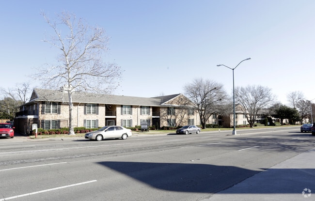

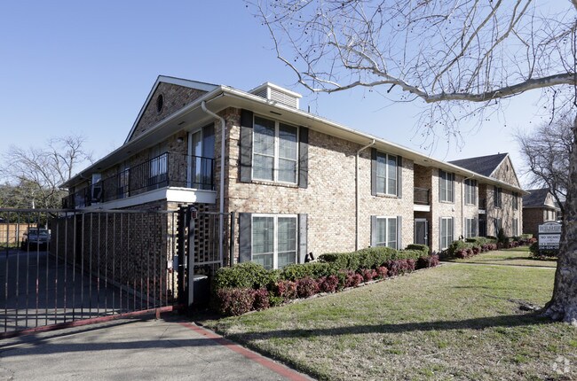
Property Detail
6151 E Mockingbird Ln
00000240763000000
CARUTH TERRACE BLK F/2953 LOT 18 619.4X140.05X622.11X140 INT200600144038 DD02022006 CO-DC 2953 00F 01800 1002953 00F
Apartment
DALLAS
Z164
Texas
B and X Area of moderate flood hazard, usually the area between the limits of the 100-year and 500-year floods.
18
2024
1.99 AC
2025
Northeast Dallas
000201
Dallas/Ft Worth
53,080 SF
Dallas-Fort Worth-Arlington, TX
NEARBY LISTINGS FOR SALE OR LEASE
DEMOGRAPHICS near 6151 E Mockingbird Ln
1 mile
3 mile
5 mile
2025 Total Population
21,193
185,709
464,367
2030 Population
21,845
192,978
482,999
Pop Growth 2025-2030
+ 3.08%
+ 3.91%
+ 4.01%
Average Age
37
37
38
2025 Total Households
10,923
88,239
223,289
HH Growth 2025-2030
+ 3.28%
+ 4.07%
+ 4.24%
Median Household Inc
$108,009
$94,811
$90,268
Avg Household Size
1.90
2.00
2.00
2025 Avg HH Vehicles
2.00
2.00
2.00
Median Home Value
$693,542
$813,619
$640,345
Median Year Built
1976
1984
1984
Nearby Places
Map Layers
Map Styles
 Street
 Aerial
Transit
 Traffic
 Biking
Places
Listings with unknown addresses are not visible on the map
- Restaurants
- Banks
- Shops
- Fitness
- Groceries
PUBLIC TRANSPORTATION
TRANSIT/SUBWAY
Smu/Mockingbird Station (DART LIGHT RAIL - BLUE LINE - Dallas Area Rapid Transit (DART), DART LIGHT RAIL - ORANGE LINE - Dallas Area Rapid Transit (DART), DART LIGHT RAIL - RED LINE - Dallas Area Rapid Transit (DART))
Drive
Walk
Distance
Smu/Mockingbird Station (DART LIGHT RAIL - BLUE LINE - Dallas Area Rapid Transit (DART), DART LIGHT RAIL - ORANGE LINE - Dallas Area Rapid Transit (DART), DART LIGHT RAIL - RED LINE - Dallas Area Rapid Transit (DART))
3 min
18 min
1.0 mi
COMMUTER RAIL
Victory Station (DART LIGHT RAIL - GREEN LINE - Dallas Area Rapid Transit (DART), DART LIGHT RAIL - ORANGE LINE - Dallas Area Rapid Transit (DART), TRINITY RAILWAY - Dallas Area Rapid Transit (DART))
Drive
Walk
Distance
Victory Station (DART LIGHT RAIL - GREEN LINE - Dallas Area Rapid Transit (DART), DART LIGHT RAIL - ORANGE LINE - Dallas Area Rapid Transit (DART), TRINITY RAILWAY - Dallas Area Rapid Transit (DART))
9 min
5.9 mi
Medical/Market Ctr Station (TRINITY RAILWAY - Dallas Area Rapid Transit (DART))
Drive
Walk
Distance
Medical/Market Ctr Station (TRINITY RAILWAY - Dallas Area Rapid Transit (DART))
13 min
7.5 mi
AIRPORT
Dallas Love Field
Drive
Walk
Distance
Dallas Love Field
13 min
5.8 mi
Dallas-Fort Worth International
Drive
Walk
Distance
Dallas-Fort Worth International
33 min
25.1 mi
Freight Ports
Port of Shreveport
Drive
Walk
Distance
Port of Shreveport
214 min
197.1 mi
Nearby Properties
Address
Land Use
TOTAL SIZE
Lot Size
Zoning
Address
Land Use
TOTAL SIZE
Lot Size
Zoning
1,634,356 SF
92.90 AC
Z421
Address
Land Use
TOTAL SIZE
Lot Size
Zoning
4,157,377 SF
76.79 AC
Z248
Address
Land Use
TOTAL SIZE
Lot Size
Zoning
858,872 SF
23.90 AC
Z421
Address
Land Use
TOTAL SIZE
Lot Size
Zoning
299,170 SF
9.71 AC
Z97
Address
Land Use
TOTAL SIZE
Lot Size
Zoning
502,529 SF
3.08 AC
Z239
Address
Land Use
TOTAL SIZE
Lot Size
Zoning
100 SF
27.05 AC
Z421
Address
Land Use
TOTAL SIZE
Lot Size
Zoning
226,331 SF
1.12 AC
Address
Land Use
TOTAL SIZE
Lot Size
Zoning
77.76 AC
Z239
Address
Land Use
TOTAL SIZE
Lot Size
Zoning
2,695,010 SF
8.69 AC
Z239
Address
Land Use
TOTAL SIZE
Lot Size
Zoning
545,752 SF
1.33 AC
Z239
Address
Land Use
TOTAL SIZE
Lot Size
Zoning
763,340 SF
8.31 AC
Z165
Address
Land Use
TOTAL SIZE
Lot Size
Zoning
447,418 SF
5.69 AC
Z236
Address
Land Use
TOTAL SIZE
Lot Size
Zoning
446,593 SF
0.93 AC
Address
Land Use
TOTAL SIZE
Lot Size
Zoning
146,302 SF
5.66 AC
Z60
Address
Land Use
TOTAL SIZE
Lot Size
Zoning
814,976 SF
8.72 AC
Z151
Address
Land Use
TOTAL SIZE
Lot Size
Zoning
801,209 SF
1.57 AC
Z239
Address
Land Use
TOTAL SIZE
Lot Size
Zoning
595,955 SF
1.42 AC
Z239
Address
Land Use
TOTAL SIZE
Lot Size
Zoning
395,377 SF
14.61 AC
Z163
Address
Land Use
TOTAL SIZE
Lot Size
Zoning
474,563 SF
2.42 AC
Z239
Address
Land Use
TOTAL SIZE
Lot Size
Zoning
749,138 SF
2.17 AC
Z239
Address
Land Use
TOTAL SIZE
Lot Size
Zoning
335,752 SF
1.24 AC
Z239
Address
Land Use
TOTAL SIZE
Lot Size
Zoning
674,474 SF
18.81 AC
Z164
Address
Land Use
TOTAL SIZE
Lot Size
Zoning
776,707 SF
8.47 AC
Address
Land Use
TOTAL SIZE
Lot Size
Zoning
240,205 SF
1.24 AC
Address
Land Use
TOTAL SIZE
Lot Size
Zoning
485,166 SF
9.89 AC
Z236
Address
Land Use
TOTAL SIZE
Lot Size
Zoning
551,820 SF
5.03 AC
Z239
Address
Land Use
TOTAL SIZE
Lot Size
Zoning
655,025 SF
3.53 AC
Z239
Address
Land Use
TOTAL SIZE
Lot Size
Zoning
717,809 SF
4.88 AC
Z239
Address
Land Use
TOTAL SIZE
Lot Size
Zoning
671,830 SF
3.16 AC
Z239
Address
Land Use
TOTAL SIZE
Lot Size
Zoning
583,186 SF
4.54 AC
Z239
The World's #1 Commercial Real Estate Marketplace
Connect with us
© 2026 CoStar Group
The information above has been obtained from sources believed reliable. While we do not doubt its accuracy we have not verified it and make no guarantee, warranty or representation about it. It is your responsibility to independently confirm its accuracy and completeness. Any projections, opinions, assumptions, or estimates used are for example only and do not represent the current or future performance of the property. The value of this transaction to you depends on tax and other factors which should be evaluated by your tax, financial, and legal advisors. You and your advisors should conduct a careful, independent investigation of the property to determine to your satisfaction the suitability of the property for your needs.