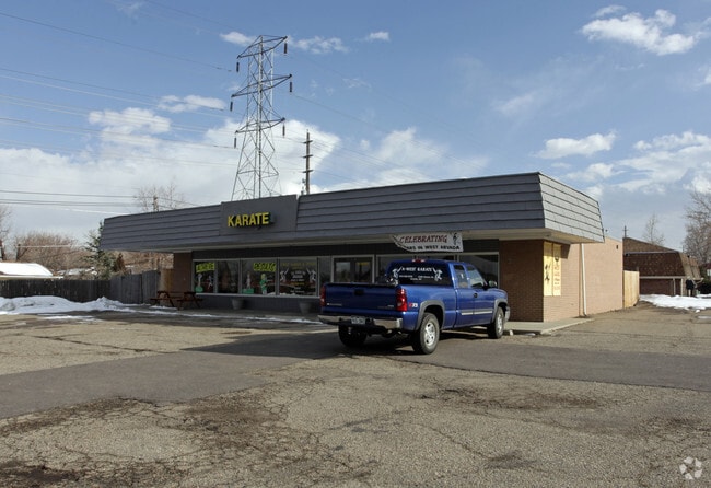
Property Record
6156 Simms St, Arvada, CO 80004

Property Detail
6156 Simms St
39-081-08-001
SECTION 08 TOWNSHIP 03 RANGE 69 QTR NE SUBDIVISIONCD 014800 SUBDIVISIONNAME ALLENDALE 5TH FLG BLOCK 00D LOT SIZE: 16509 TRACT 00A VALUE: .379
Commercialnec
Jefferson
B and X Area of moderate flood hazard, usually the area between the limits of the 100-year and 500-year floods.
Colorado
2023
0.38 AC
2024
Northwest
010306
Denver
2,400 SF
Denver-Aurora-Centennial, CO
NEARBY LISTINGS FOR SALE OR LEASE
DEMOGRAPHICS near 6156 Simms St
1 mile
3 mile
5 mile
2025 Total Population
14,795
92,306
219,927
2030 Population
14,733
91,991
219,411
Pop Growth 2025-2030
(0.42%)
(0.34%)
(0.23%)
Average Age
42
43
42
2025 Total Households
6,073
38,260
90,452
HH Growth 2025-2030
(0.51%)
(0.38%)
(0.25%)
Median Household Inc
$99,793
$105,067
$102,474
Avg Household Size
2.40
2.30
2.40
2025 Avg HH Vehicles
2.00
2.00
2.00
Median Home Value
$689,771
$708,497
$688,862
Median Year Built
1976
1977
1976
Nearby Places
Map Layers
Map Styles
 Street
 Aerial
Transit
 Traffic
 Biking
Places
Listings with unknown addresses are not visible on the map
- Restaurants
- Banks
- Shops
- Fitness
- Groceries
PUBLIC TRANSPORTATION
COMMUTER RAIL
Drive
Walk
Distance
5 min
2.1 mi
Drive
Walk
Distance
5 min
2.1 mi
AIRPORT
Denver International
Drive
Walk
Distance
Denver International
43 min
31.5 mi
SALE & LEASE HISTORY
LISTING DATE
SALE/LEASE

Oct 12, 2022
For Sale
Nearby Properties
Address
Land Use
TOTAL SIZE
Lot Size
Zoning
Address
Land Use
TOTAL SIZE
Lot Size
Zoning
830,160 SF
26.93 AC
Address
Land Use
TOTAL SIZE
Lot Size
Zoning
269,013 SF
31.89 AC
Address
Land Use
TOTAL SIZE
Lot Size
Zoning
253,643 SF
50.87 AC
A2
Address
Land Use
TOTAL SIZE
Lot Size
Zoning
365,230 SF
12.51 AC
Address
Land Use
TOTAL SIZE
Lot Size
Zoning
389,561 SF
10.73 AC
Address
Land Use
TOTAL SIZE
Lot Size
Zoning
215,878 SF
11.82 AC
A2
Address
Land Use
TOTAL SIZE
Lot Size
Zoning
131,135 SF
2.83 AC
Address
Land Use
TOTAL SIZE
Lot Size
Zoning
262,699 SF
13.10 AC
A2
Address
Land Use
TOTAL SIZE
Lot Size
Zoning
363,989 SF
30.10 AC
Address
Land Use
TOTAL SIZE
Lot Size
Zoning
101,761 SF
4.34 AC
Address
Land Use
TOTAL SIZE
Lot Size
Zoning
142,200 SF
9.82 AC
Address
Land Use
TOTAL SIZE
Lot Size
Zoning
520,896 SF
24.42 AC
I1
Address
Land Use
TOTAL SIZE
Lot Size
Zoning
149,115 SF
18 AC
Address
Land Use
TOTAL SIZE
Lot Size
Zoning
125,884 SF
8.88 AC
Address
Land Use
TOTAL SIZE
Lot Size
Zoning
91,734 SF
9.69 AC
Address
Land Use
TOTAL SIZE
Lot Size
Zoning
130,662 SF
9.67 AC
Address
Land Use
TOTAL SIZE
Lot Size
Zoning
223,338 SF
9.42 AC
I1
Address
Land Use
TOTAL SIZE
Lot Size
Zoning
82,055 SF
19.39 AC
Address
Land Use
TOTAL SIZE
Lot Size
Zoning
78,494 SF
5.68 AC
Address
Land Use
TOTAL SIZE
Lot Size
Zoning
68,300 SF
6 AC
Address
Land Use
TOTAL SIZE
Lot Size
Zoning
174,853 SF
14.68 AC
Address
Land Use
TOTAL SIZE
Lot Size
Zoning
169,525 SF
2.93 AC
Address
Land Use
TOTAL SIZE
Lot Size
Zoning
67,520 SF
6.46 AC
Address
Land Use
TOTAL SIZE
Lot Size
Zoning
51,987 SF
15.23 AC
PD
Address
Land Use
TOTAL SIZE
Lot Size
Zoning
83,684 SF
8.15 AC
Address
Land Use
TOTAL SIZE
Lot Size
Zoning
150,321 SF
6.52 AC
Address
Land Use
TOTAL SIZE
Lot Size
Zoning
224,923 SF
33.71 AC
Address
Land Use
TOTAL SIZE
Lot Size
Zoning
201,582 SF
5.78 AC
Address
Land Use
TOTAL SIZE
Lot Size
Zoning
22,524 SF
3.74 AC
Address
Land Use
TOTAL SIZE
Lot Size
Zoning
265,676 SF
2.03 AC
The World's #1 Commercial Real Estate Marketplace
Connect with us
© 2026 CoStar Group
The information above has been obtained from sources believed reliable. While we do not doubt its accuracy we have not verified it and make no guarantee, warranty or representation about it. It is your responsibility to independently confirm its accuracy and completeness. Any projections, opinions, assumptions, or estimates used are for example only and do not represent the current or future performance of the property. The value of this transaction to you depends on tax and other factors which should be evaluated by your tax, financial, and legal advisors. You and your advisors should conduct a careful, independent investigation of the property to determine to your satisfaction the suitability of the property for your needs.