Property Record
625 W Wrightwood Ave, Chicago, IL 60614
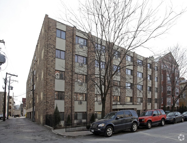


Property Detail
625 W Wrightwood Ave
14-28-313-063-0000
Cook
Apartment
Illinois
RM-5
0.49 AC
B and X Area of moderate flood hazard, usually the area between the limits of the 100-year and 500-year floods.
Lincoln Park
2023
Chicago
2025
Chicago-Naperville-Elgin, IL-IN
070200
NEARBY LISTINGS FOR SALE OR LEASE
DEMOGRAPHICS near 625 W Wrightwood Ave
1 mile
3 mile
5 mile
2025 Total Population
91,881
474,541
978,523
2030 Population
93,053
479,635
980,063
Pop Growth 2025-2030
+ 1.28%
+ 1.07%
+ 0.16%
Average Age
36
37
37
2025 Total Households
50,661
255,901
485,065
HH Growth 2025-2030
+ 1.04%
+ 1.03%
+ 0.32%
Median Household Inc
$109,557
$116,613
$103,116
Avg Household Size
1.70
1.80
1.90
2025 Avg HH Vehicles
1.00
1.00
1.00
Median Home Value
$640,184
$590,525
$485,499
Median Year Built
1963
1970
1963
Nearby Places
Map Layers
Map Styles
 Street
 Aerial
Layers
 Traffic
 Biking
Places
Listings with unknown addresses are not visible on the map
- Restaurants
- Banks
- Shops
- Fitness
- Groceries
PUBLIC TRANSPORTATION
TRANSIT/SUBWAY
Diversey Station (Brown Line - Chicago Transit Authority "L" Trains (The "L"), Purple Line - Chicago Transit Authority "L" Trains (The "L"))
Drive
Walk
Distance
Diversey Station (Brown Line - Chicago Transit Authority "L" Trains (The "L"), Purple Line - Chicago Transit Authority "L" Trains (The "L"))
2 min
13 min
0.7 mi
Fullerton Station (Brown Line - Chicago Transit Authority "L" Trains (The "L"), Purple Line - Chicago Transit Authority "L" Trains (The "L"), Red Line - Chicago Transit Authority "L" Trains (The "L"))
Drive
Walk
Distance
Fullerton Station (Brown Line - Chicago Transit Authority "L" Trains (The "L"), Purple Line - Chicago Transit Authority "L" Trains (The "L"), Red Line - Chicago Transit Authority "L" Trains (The "L"))
2 min
14 min
0.7 mi
Wellington Station (Brown Line - Chicago Transit Authority "L" Trains (The "L"), Purple Line - Chicago Transit Authority "L" Trains (The "L"))
Drive
Walk
Distance
Wellington Station (Brown Line - Chicago Transit Authority "L" Trains (The "L"), Purple Line - Chicago Transit Authority "L" Trains (The "L"))
2 min
17 min
0.9 mi
Belmont Station (Brown, Purple, Red Lines) (Brown Line - Chicago Transit Authority "L" Trains (The "L"), Purple Line - Chicago Transit Authority "L" Trains (The "L"), Red Line - Chicago Transit Authority "L" Trains (The "L"))
Drive
Walk
Distance
Belmont Station (Brown, Purple, Red Lines) (Brown Line - Chicago Transit Authority "L" Trains (The "L"), Purple Line - Chicago Transit Authority "L" Trains (The "L"), Red Line - Chicago Transit Authority "L" Trains (The "L"))
2 min
19 min
1.0 mi
COMMUTER RAIL
Clybourn Station (Union Pacific North Line - Northeast Illinois Regional Commuter Railroad (Metra), Union Pacific Northwest Line - Northeast Illinois Regional Commuter Railroad (Metra))
Drive
Walk
Distance
Clybourn Station (Union Pacific North Line - Northeast Illinois Regional Commuter Railroad (Metra), Union Pacific Northwest Line - Northeast Illinois Regional Commuter Railroad (Metra))
5 min
2.4 mi
Ravenswood Station (Union Pacific North Line - Northeast Illinois Regional Commuter Railroad (Metra))
Drive
Walk
Distance
Ravenswood Station (Union Pacific North Line - Northeast Illinois Regional Commuter Railroad (Metra))
7 min
3.4 mi
AIRPORT
Chicago O'Hare International
Drive
Walk
Distance
Chicago O'Hare International
25 min
15.8 mi
Chicago Midway International
Drive
Walk
Distance
Chicago Midway International
24 min
16.0 mi
Freight Ports
Port Milwaukee
Drive
Walk
Distance
Port Milwaukee
103 min
84.0 mi
Nearby Properties
Address
Land Use
TOTAL SIZE
Lot Size
Zoning
Address
Land Use
TOTAL SIZE
Lot Size
Zoning
1,396,750 SF
4.09 AC
PD 98
Address
Land Use
TOTAL SIZE
Lot Size
Zoning
4,296,046 SF
6.15 AC
DC-16
Address
Land Use
TOTAL SIZE
Lot Size
Zoning
3,914,400 SF
5.70 AC
DC-16
Address
Land Use
TOTAL SIZE
Lot Size
Zoning
PD 1115
Address
Land Use
TOTAL SIZE
Lot Size
Zoning
0.88 AC
DC-16,PD 9
Address
Land Use
TOTAL SIZE
Lot Size
Zoning
831,084 SF
2.05 AC
PD 316
Address
Land Use
TOTAL SIZE
Lot Size
Zoning
1,502,279 SF
3.79 AC
PD 98
Address
Land Use
TOTAL SIZE
Lot Size
Zoning
1,051,000 SF
0.93 AC
PD 325
Address
Land Use
TOTAL SIZE
Lot Size
Zoning
1.02 AC
PD 325
Address
Land Use
TOTAL SIZE
Lot Size
Zoning
0.35 AC
PD 325
Address
Land Use
TOTAL SIZE
Lot Size
Zoning
1,857,394 SF
3.13 AC
PD 447
Address
Land Use
TOTAL SIZE
Lot Size
Zoning
1,109,372 SF
1.66 AC
PD 368
Address
Land Use
TOTAL SIZE
Lot Size
Zoning
1.09 AC
B1-3
Address
Land Use
TOTAL SIZE
Lot Size
Zoning
491,382 SF
2.05 AC
PD 316
Address
Land Use
TOTAL SIZE
Lot Size
Zoning
948,900 SF
0.74 AC
DC-16
Address
Land Use
TOTAL SIZE
Lot Size
Zoning
433,026 SF
0.47 AC
DX-12
Address
Land Use
TOTAL SIZE
Lot Size
Zoning
1,578,363 SF
2.62 AC
DX-12
Address
Land Use
TOTAL SIZE
Lot Size
Zoning
717,243 SF
1.01 AC
PD 790
Address
Land Use
TOTAL SIZE
Lot Size
Zoning
559,589 SF
1.72 AC
C3-5
Address
Land Use
TOTAL SIZE
Lot Size
Zoning
821,186 SF
PD 368
Address
Land Use
TOTAL SIZE
Lot Size
Zoning
207,756 SF
1.58 AC
PD 368
Address
Land Use
TOTAL SIZE
Lot Size
Zoning
0.72 AC
PD 1403
Address
Land Use
TOTAL SIZE
Lot Size
Zoning
1,284,706 SF
4.40 AC
Address
Land Use
TOTAL SIZE
Lot Size
Zoning
229,725 SF
1.21 AC
DX-12,DX-1
Address
Land Use
TOTAL SIZE
Lot Size
Zoning
403,219 SF
1.42 AC
DX-12,DX-1
Address
Land Use
TOTAL SIZE
Lot Size
Zoning
1,101,926 SF
0.69 AC
DC-16
Address
Land Use
TOTAL SIZE
Lot Size
Zoning
549,130 SF
1.45 AC
DX-12
Address
Land Use
TOTAL SIZE
Lot Size
Zoning
594,987 SF
1.11 AC
PD 1407
Address
Land Use
TOTAL SIZE
Lot Size
Zoning
1,552,782 SF
1.05 AC
PD 65
Address
Land Use
TOTAL SIZE
Lot Size
Zoning
0.54 AC
PD 65
The World's #1 Commercial Real Estate Marketplace
Connect with us
© 2026 CoStar Group
The information above has been obtained from sources believed reliable. While we do not doubt its accuracy we have not verified it and make no guarantee, warranty or representation about it. It is your responsibility to independently confirm its accuracy and completeness. Any projections, opinions, assumptions, or estimates used are for example only and do not represent the current or future performance of the property. The value of this transaction to you depends on tax and other factors which should be evaluated by your tax, financial, and legal advisors. You and your advisors should conduct a careful, independent investigation of the property to determine to your satisfaction the suitability of the property for your needs.