Property Record
6261 Rivers Bend Dr, Maineville, OH 45039


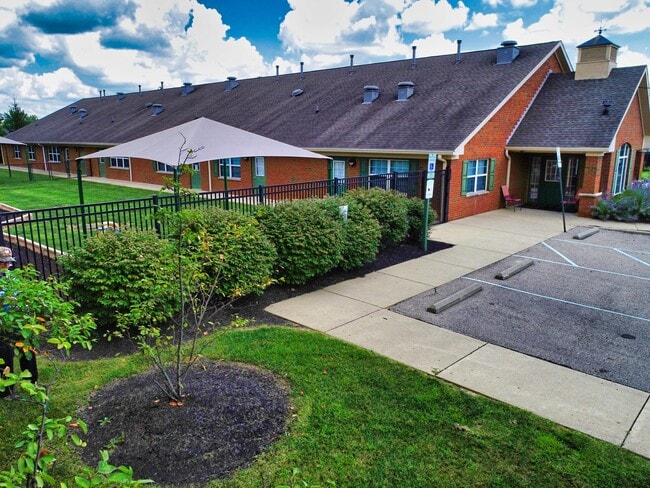
Property Detail
6261 Rivers Bend Dr
Cincinnati, OH-KY-IN
RIVERS BN.COMM.CNTR LOT 5
16-05-201-026
Warren
Commercialnec
Ohio
B and X Area of moderate flood hazard, usually the area between the limits of the 100-year and 500-year floods.
5
2024
2.03 AC
2025
Outlying Warren County
032203
Cincinnati/Dayton
11,620 SF
NEARBY LISTINGS FOR SALE OR LEASE
DEMOGRAPHICS near 6261 Rivers Bend Dr
1 mile
3 mile
5 mile
2025 Total Population
6,549
38,129
83,656
2030 Population
6,965
40,306
87,805
Pop Growth 2025-2030
+ 6.35%
+ 5.71%
+ 4.96%
Average Age
40
40
40
2025 Total Households
2,371
13,866
31,252
HH Growth 2025-2030
+ 6.33%
+ 5.70%
+ 4.91%
Median Household Inc
$134,224
$119,294
$118,315
Avg Household Size
2.70
2.70
2.60
2025 Avg HH Vehicles
2.00
2.00
2.00
Median Home Value
$362,453
$361,677
$379,586
Median Year Built
2001
2001
1996
Nearby Places
Map Layers
Map Styles
 Street
 Aerial
Transit
 Traffic
 Biking
Places
Listings with unknown addresses are not visible on the map
- Restaurants
- Banks
- Shops
- Fitness
- Groceries
PUBLIC TRANSPORTATION
AIRPORT
Cincinnati/Northern Kentucky International
Drive
Walk
Distance
Cincinnati/Northern Kentucky International
64 min
39.9 mi
SALE & LEASE HISTORY
LISTING DATE
SALE/LEASE

Sep 20, 2022
For Sale
Nearby Properties
Address
Land Use
TOTAL SIZE
Lot Size
Zoning
Address
Land Use
TOTAL SIZE
Lot Size
Zoning
Address
Land Use
TOTAL SIZE
Lot Size
Zoning
590.28 AC
Address
Land Use
TOTAL SIZE
Lot Size
Zoning
219,265 SF
41.57 AC
Address
Land Use
TOTAL SIZE
Lot Size
Zoning
13,461 SF
47.72 AC
Address
Land Use
TOTAL SIZE
Lot Size
Zoning
102.64 AC
Address
Land Use
TOTAL SIZE
Lot Size
Zoning
23.89 AC
Address
Land Use
TOTAL SIZE
Lot Size
Zoning
45.96 AC
Address
Land Use
TOTAL SIZE
Lot Size
Zoning
Address
Land Use
TOTAL SIZE
Lot Size
Zoning
18,400 SF
56.65 AC
Address
Land Use
TOTAL SIZE
Lot Size
Zoning
21.26 AC
Address
Land Use
TOTAL SIZE
Lot Size
Zoning
9,432 SF
40.41 AC
Address
Land Use
TOTAL SIZE
Lot Size
Zoning
Address
Land Use
TOTAL SIZE
Lot Size
Zoning
21,601 SF
12.40 AC
Address
Land Use
TOTAL SIZE
Lot Size
Zoning
Address
Land Use
TOTAL SIZE
Lot Size
Zoning
117,046 SF
20.33 AC
Address
Land Use
TOTAL SIZE
Lot Size
Zoning
39,415 SF
18.67 AC
Address
Land Use
TOTAL SIZE
Lot Size
Zoning
Address
Land Use
TOTAL SIZE
Lot Size
Zoning
155,746 SF
15.15 AC
Address
Land Use
TOTAL SIZE
Lot Size
Zoning
98,816 SF
31 AC
Address
Land Use
TOTAL SIZE
Lot Size
Zoning
16,196 SF
5.81 AC
Address
Land Use
TOTAL SIZE
Lot Size
Zoning
Address
Land Use
TOTAL SIZE
Lot Size
Zoning
49.39 AC
Address
Land Use
TOTAL SIZE
Lot Size
Zoning
28,120 SF
11.92 AC
Address
Land Use
TOTAL SIZE
Lot Size
Zoning
58,761 SF
15.10 AC
Address
Land Use
TOTAL SIZE
Lot Size
Zoning
Address
Land Use
TOTAL SIZE
Lot Size
Zoning
Address
Land Use
TOTAL SIZE
Lot Size
Zoning
18.03 AC
Address
Land Use
TOTAL SIZE
Lot Size
Zoning
13,742 SF
4.70 AC
Address
Land Use
TOTAL SIZE
Lot Size
Zoning
23,316 SF
1.53 AC
Address
Land Use
TOTAL SIZE
Lot Size
Zoning
34,311 SF
16.76 AC
The World's #1 Commercial Real Estate Marketplace
Connect with us
© 2026 CoStar Group
The information above has been obtained from sources believed reliable. While we do not doubt its accuracy we have not verified it and make no guarantee, warranty or representation about it. It is your responsibility to independently confirm its accuracy and completeness. Any projections, opinions, assumptions, or estimates used are for example only and do not represent the current or future performance of the property. The value of this transaction to you depends on tax and other factors which should be evaluated by your tax, financial, and legal advisors. You and your advisors should conduct a careful, independent investigation of the property to determine to your satisfaction the suitability of the property for your needs.