Property Record
6265 S 7Th St, Abilene, TX 79605
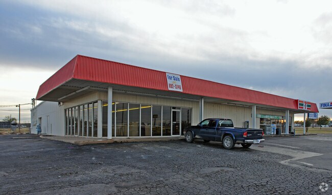

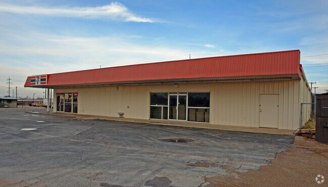
Property Detail
6265 S 7Th St
Abilene, TX
WESTERN HILLS, BLOCK 8, LOT W128 LT 1&2 ALL 3 & SE 8FT OF2
58318
TAYLOR
Multipleuses
Texas
C and X Area of minimal flood hazard, usually depicted on FIRMs as above the 500-year flood level.
1
2024
0.55 AC
2025
Abilene
013100
Other Market Areas
7,345 SF
NEARBY LISTINGS FOR SALE OR LEASE
DEMOGRAPHICS near 6265 S 7Th St
1 mile
3 mile
5 mile
2025 Total Population
3,296
40,478
87,899
2030 Population
3,465
42,395
91,466
Pop Growth 2025-2030
+ 5.13%
+ 4.74%
+ 4.06%
Average Age
35
35
37
2025 Total Households
1,227
15,688
34,103
HH Growth 2025-2030
+ 5.46%
+ 4.90%
+ 4.21%
Median Household Inc
$51,206
$59,708
$56,649
Avg Household Size
2.40
2.50
2.40
2025 Avg HH Vehicles
2.00
2.00
2.00
Median Home Value
$89,444
$172,855
$155,274
Median Year Built
1978
1970
1966
Nearby Places
Map Layers
Map Styles
 Street
 Aerial
Transit
 Traffic
 Biking
Places
Listings with unknown addresses are not visible on the map
- Restaurants
- Banks
- Shops
- Fitness
- Groceries
PUBLIC TRANSPORTATION
AIRPORT
Abilene Regional
Drive
Walk
Distance
Abilene Regional
18 min
9.4 mi
Nearby Properties
Address
Land Use
TOTAL SIZE
Lot Size
Zoning
Address
Land Use
TOTAL SIZE
Lot Size
Zoning
227.42 AC
Address
Land Use
TOTAL SIZE
Lot Size
Zoning
183,321 SF
11.67 AC
Address
Land Use
TOTAL SIZE
Lot Size
Zoning
117,207 SF
17.41 AC
Address
Land Use
TOTAL SIZE
Lot Size
Zoning
162,480 SF
9.88 AC
Address
Land Use
TOTAL SIZE
Lot Size
Zoning
95,893 SF
15.89 AC
Address
Land Use
TOTAL SIZE
Lot Size
Zoning
176,378 SF
36.99 AC
Address
Land Use
TOTAL SIZE
Lot Size
Zoning
73,947 SF
9.89 AC
Address
Land Use
TOTAL SIZE
Lot Size
Zoning
161,050 SF
12.18 AC
Address
Land Use
TOTAL SIZE
Lot Size
Zoning
155,780 SF
18.80 AC
Address
Land Use
TOTAL SIZE
Lot Size
Zoning
121,816 SF
3.06 AC
Address
Land Use
TOTAL SIZE
Lot Size
Zoning
9.55 AC
Address
Land Use
TOTAL SIZE
Lot Size
Zoning
150,552 SF
9.72 AC
Address
Land Use
TOTAL SIZE
Lot Size
Zoning
210,556 SF
24.67 AC
Address
Land Use
TOTAL SIZE
Lot Size
Zoning
78,522 SF
41.23 AC
Address
Land Use
TOTAL SIZE
Lot Size
Zoning
140,297 SF
7.99 AC
Address
Land Use
TOTAL SIZE
Lot Size
Zoning
104,728 SF
17.56 AC
Address
Land Use
TOTAL SIZE
Lot Size
Zoning
115,042 SF
7.68 AC
Address
Land Use
TOTAL SIZE
Lot Size
Zoning
115,808 SF
5.21 AC
Address
Land Use
TOTAL SIZE
Lot Size
Zoning
241,784 SF
24.28 AC
Address
Land Use
TOTAL SIZE
Lot Size
Zoning
177,960 SF
8.56 AC
Address
Land Use
TOTAL SIZE
Lot Size
Zoning
114,420 SF
6.90 AC
Address
Land Use
TOTAL SIZE
Lot Size
Zoning
162,536 SF
10.79 AC
Address
Land Use
TOTAL SIZE
Lot Size
Zoning
120,789 SF
2.41 AC
Address
Land Use
TOTAL SIZE
Lot Size
Zoning
91,119 SF
7.02 AC
Address
Land Use
TOTAL SIZE
Lot Size
Zoning
155,848 SF
8.50 AC
Address
Land Use
TOTAL SIZE
Lot Size
Zoning
41,205 SF
1.47 AC
Address
Land Use
TOTAL SIZE
Lot Size
Zoning
171,428 SF
17.31 AC
Address
Land Use
TOTAL SIZE
Lot Size
Zoning
68,610 SF
11.99 AC
Address
Land Use
TOTAL SIZE
Lot Size
Zoning
97,218 SF
11.75 AC
Address
Land Use
TOTAL SIZE
Lot Size
Zoning
53,751 SF
31.97 AC
The World's #1 Commercial Real Estate Marketplace
Connect with us
© 2026 CoStar Group
The information above has been obtained from sources believed reliable. While we do not doubt its accuracy we have not verified it and make no guarantee, warranty or representation about it. It is your responsibility to independently confirm its accuracy and completeness. Any projections, opinions, assumptions, or estimates used are for example only and do not represent the current or future performance of the property. The value of this transaction to you depends on tax and other factors which should be evaluated by your tax, financial, and legal advisors. You and your advisors should conduct a careful, independent investigation of the property to determine to your satisfaction the suitability of the property for your needs.